Also shows anchorages, currents, and routes of navigation along the coast., Includes historical notes, text, 10 insets of harbors, and a table showing that "North America is divided into the continent & the islands" according to geography and politics., and Rel
Publisher:
Printed for Robt. Sayer,
Subject (Geographic):
North America--Maps--Early works to 1800
Subject (Name):
Anville, Jean Baptiste Bourguignon d', 1697-1782 and Robert de Vaugondy, Didier, 1723-1786
Veue et perspective de la ville de Londre, Westminster et Parc St. Jacques and View of London and Westminster by John Kip, circa 1710-1720
Description:
"To Her Royal Highness Wilhelmina Carolina, the most illustrious Princess of Wales, this prospect of London, Westminster & St. James's Park is most humbly dedicated by John Kip.", In lower margin: Key to selected buildings or places of interest,, and Panorama.
Publisher:
London Topographical Society,
Subject (Geographic):
London (England)--Pictorial works--Early works to 1800--Facsimiles
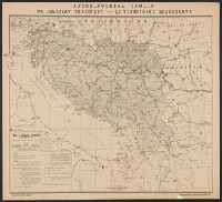
Map of Jugoslav territory and Map of Southern Slav territory
Description:
Imperfect: Cover wanting. Overprint in red on map indicating "Territory occupied by Italy 4000 S.q Mi.". Red stamp in upper right corner of sheet: "American Embassy. Paris, France Dec. 13, 1918"., Legend in English, Croatian, and French., and Sh
Publisher:
Christophers,
Subject (Geographic):
Yugoslavia--Maps and Yugoslavia--Maps--1915
Subject (Topic):
Ethnology--Yugoslavia--Maps and World War, 1914-1918--Maps
Jugoslav territory, Jugoslovenska zemlja, Map of southern Slav territory, and Territoire Iougoslave
Description:
"Issued for the Jugoslav Committee in London.", "September, 1915, London.", In upper margin: "Jugoslovenska zemlja, the Jugoslav territory, le territoire Iougoslave.", Includes "Jugoslav orthography.", and Legend in English, Croatian, and French.