Skip to search
Skip to main content
Skip to first result
Search
You Searched For
Extent of Digitization
Completely digitized
Format
cartographic
Creator
United States. Army Map Service
New Search
Search Results
Creator:
Published / Created:
1943
Call Number:
39 P962 1943
Container / Volume:
BRBL_00190
Image Count:
1
Resource Type:
Maps, Atlases & Globes
Alternative Title:
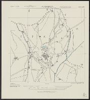
M981 and Puigcerda city plan
Description:
"3-43.", "Copied from Spanish Map, 1:50,000, Puigcerda, No. 217, 1934.", and "First edition 1943."
Publisher:
Army Map Service, U.S. Army,
Subject (Geographic):
Puigcerdá (Spain)--Maps
Found in:
Beinecke Rare Book and Manuscript Library > Spain 1:10,000. Puigcerda city plan / prepared under the direction of the Chief of Engineers, U.S. Army [cartographic material].
Creator:
Published / Created:
1943
Call Number:
39 R31 1943
Container / Volume:
BRBL_00190
Image Count:
1
Resource Type:
Maps, Atlases & Globes
Alternative Title:
M981 and Reus city plan
Description:
"3-43.", "First edition 1943.", "Prepared from Spanish map 1:50,000, 472; Europe B 24-MG-33.", and Some buildings are named; street names are indicated by numbers and a key.
Publisher:
Army Map Service, U.S. Army,
Subject (Geographic):
Reus (Spain)--Maps
Found in:
Beinecke Rare Book and Manuscript Library > Spain 1:10,000. Reus city plan / prepared under the direction of the Chief of Engineers, U.S. Army [cartographic material].
Creator:
Published / Created:
1943
Call Number:
39 Sa51 1943
Container / Volume:
BRBL_00191
Image Count:
1
Resource Type:
Maps, Atlases & Globes
Alternative Title:
M981 and San Carlos de la Rapita city plan
Description:
"3-43.", "Copied from Spanish Map, 1:50,000, Alcanar No. 547, 1920.", and "First edition 1943."
Publisher:
Army Map Service, U.S. Army,
Subject (Geographic):
San Carlos de la Rápita (Spain)--Maps
Found in:
Beinecke Rare Book and Manuscript Library > Spain 1:10,000. San Carlos de la Rapita city plan / prepared under the direction of the Chief of Engineers, U.S. Army [cartographic material].
Creator:
Published / Created:
1943
Call Number:
39 Sa52 1943
Container / Volume:
BRBL_00191
Image Count:
1
Resource Type:
Maps, Atlases & Globes
Alternative Title:
M981 and San Fernando city plan
Description:
"3-43.", "Copied from Spanish H.O. chart no. 82A, 1928.", "First edition 1943.", Military grid (blue)., and Some buildings are named.
Publisher:
Army Map Service, U.S. Army,
Subject (Geographic):
San Fernando (Spain)--Maps
Subject (Name):
Spain. Servicio Hidrográfico
Found in:
Beinecke Rare Book and Manuscript Library > Spain 1:10,000. San Fernando city plan / prepared under the direction of the Chief of Engineers, U.S. Army [cartographic material].
Creator:
Published / Created:
1943
Call Number:
39 Sa59 1943
Container / Volume:
BRBL_00191
Image Count:
1
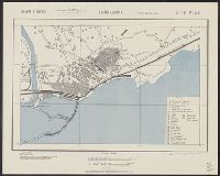
Resource Type:
Maps, Atlases & Globes
Alternative Title:
M981 and Santander city plan
Description:
"3-43.", "Copied from I.S.I.S. report, 1:10,000, Port Santander, CB 1811, no. 7, 1942.", "First edition 1943.", Relief shown by land form drawings and rock drawings., and Some streets and buildings are named.
Publisher:
Army Map Service, U.S. Army,
Subject (Geographic):
Santander (Spain)--Maps
Found in:
Beinecke Rare Book and Manuscript Library > Spain 1:10,000. Santander city plan / prepared under the direction of the Chief of Engineers, U.S. Army [cartographic material].
Creator:
Published / Created:
1943
Call Number:
39 T17 1943
Container / Volume:
BRBL_00191
Image Count:
1
Resource Type:
Maps, Atlases & Globes
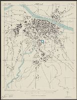
Alternative Title:
[Series] M981 and Tarragona city plan
Description:
"3-43.", "Copied from Spanish Map, 1:50,000, 473, Tarragona 1920 and I.S.I.S. Report 1:6,700, Tarragona CB 1811 Map 21, 1942.", "First edition 1943.", Includes index to streets and buildings., and Some streets and buildings are named.
Publisher:
Army Map Service, U.S. Army,
Subject (Geographic):
Tarragona (Spain)--Maps
Found in:
Beinecke Rare Book and Manuscript Library > Spain 1:10,000. Tarragona city plan / prepared under the direction of the Chief of Engineers, U.S. Army [cartographic material].
Creator:
Published / Created:
1943
Call Number:
39 V231 1943
Container / Volume:
BRBL_00192
Image Count:
1
Resource Type:
Maps, Atlases & Globes
Alternative Title:
[Series] M981 and Valencia city plan
Description:
"3-43.", "Copied from I.S.I.S. report, 1:10,000, Valencia, CB 1811, no. 20, 1942. Revised in part from aerial photographs.", "First edition 1943.", Oriented with north toward upper left., and Some streets and buildings are named.
Publisher:
Army Map Service, U.S. Army,
Subject (Geographic):
Valencia (Spain)--Maps
Found in:
Beinecke Rare Book and Manuscript Library > Spain 1:10,000. Valencia city plan / prepared under the direction of the Chief of Engineers, U.S. Army [cartographic material].
Creator:
Published / Created:
1943
Call Number:
39 Z19 1943
Container / Volume:
BRBL_00192
Image Count:
1
Resource Type:
Maps, Atlases & Globes
Alternative Title:
M981 and Zaragoza city plan
Description:
"3-43.", "Copied from Spanish Map, 1:50,000, No. 383, Zaragoza 1926, and references from Plano de Zaragoza, 1:7,000, by A. Martin, Barcelona.", "First edition 1943.", Military grid (blue)., and Some streets and buildings are named.
Publisher:
Army Map Service, U.S. Army,
Subject (Geographic):
Zaragoza (Spain)--Maps
Found in:
Beinecke Rare Book and Manuscript Library > Spain 1:10,000. Zaragoza city plan / prepared under the direction of the Chief of Engineers, U.S. Army [cartographic material].
Branch:v1.61.6 ,Deployed:2024-06-12T09:55:33-04:00