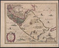
Cross Collection no. 350., From Jodocus Hondius's Appendix Atlantis majoris. [Amsterdam] : Per Iodocum Hondium, 1630., Imperfect: mutilated along fold at bottom, with no loss of text. Mounted on linen., Map of the Straits of Magellan, South America., Relief shown pictorially., and Title in Latin; place names in Dutch.
Publisher:
Judocus Hondius excudit,
Subject (Geographic):
Magellan, Strait of (Chile and Argentina)--Maps--Early works to 1800
Subject (Name):
Gryp, Dirck, engraver and Hondius, Jodocus, 1594 or 1595-1629. Appendix Atlantis majoris
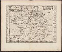
Atlas novus. and Gallia vetus ad Julij Caesaris commentaria
Description:
Latin text on recto; Dutch text on verso., Lower left corner: "Amstelodami apud Ioannem Ianβonium.", Published in Dutch editions of Jansson's Atlas novus (Dutch title: Nieuwen atlas, ofte vveerelts-beschrijvinge), vol. 6, ca. 1662, and Relief shown pictorially.
Publisher:
Jan Jansson,
Subject (Geographic):
France--History--To 987--Maps--Early works to 1800 and Gaul--Maps--Early works to 1800
Broeck, Crispin van den, 1524-ca. 1591 Visscher, Nicolaes, 1618-1679
Published / Created:
[ca. 1660]
Call Number:
1983 Folio 19
Collection Title:
[Atlas factice of 96 maps by Blaeu, Visscher, Jansson, Hondius and others]
Image Count:
2
Alternative Title:
Armenia Maior and Asia et Armenia Minor
Description:
Imperfect: illustrations at top cut-out and replaced with ms. titles "Asia et Armenia minor" (upper left) and "Armenia minor" (in upper right); torn along fold and at left edge, with some loss of text. Sheet measures 32 x 47.8 cm. Reinforced along edges with printed waste. No. 85 of 92 maps bound together. and Numbered 91 on verso.
Publisher:
[Nicolaes Visscher]
Subject (Geographic):
Armenia --Maps --Early works to 1800, Assyria --Maps, Egypt --Maps --Early works to 1800, Middle east --Maps --Early works to 1800, Palestine --Geography --Maps --Early works to 1800, Saudi Arabia --Maps, Syria --Maps, and Turkey --Maps
Jaarboek van het mijnwezen in Nederlandsch Oost-Indië.
Description:
Coordinates not present on map and are approximated., Relief shown by contour lines., and Removed from: Jaarboek van het Mijnwezen in Nederlandsch Oost-Indië (1872).
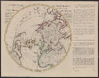
"Corrigée de nouveau sur la carte de Mr. Johannes Kyrilow ... ", Hand col. Lada-Mocarski Collection., Includes text of letter (in French and Dutch) written by "Monsieur Swartz ... a St. Petersbourg, and Title and place names in French. Text in French and Dutch.
Inset: [1.] Hoogtekaart, tevens aanwijzende de veranderingen van land en water sedert het einde der 13de eeuw (17 x 19 cm); [2.] Omstreken van Arnhem (scale 1:100 000; 13 x 32 cm); [3.] De spoorweg- en havenwerken te Amsterdam (scale 1:40 000; 2 x 16,5 cm