Skip to search
Skip to main content
Skip to first result
Search
You Searched For
Date
Unknown
Genre
Maps
Date Created
[Missing]
New Search
Search Results
Creator:
Call Number:
304 1712
Container / Volume:
BRBL_00033
Image Count:
1
Resource Type:
Maps, Atlases & Globes
Alternative Title:
General Diet of the Empire, or its Parliament.
Description:
Inset illustration of the Reichstag of Holy Roman Empire, with title: The General Diet of the Empire, or it's Parliament.
Subject (Geographic):
Europe, Central--Maps--Early works to 1800, Germany--Maps--Early works to 1800, Hungary--Maps--Early works to 1800, Romania--Maps--Early works to 1800, and Switzerland--Maps--Early works to 1800
Subject (Name):
Holy Roman Empire.--Reichstag and Hughes, Thomas Lowe,--1925---Ownership
Found in:
Beinecke Rare Book and Manuscript Library > A new map of Germany, Hungary, Transilvania & the Suisse cantons : with many remarks not extant in any map : according to ye newest and most exact observations / by Herman Moll, geographer.
Call Number:
Zc20 720so
Collection Title:
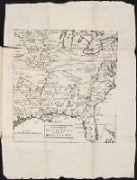
Some considerations on the consequences of the French settling colonies on the Mississippi, with
Image Count:
1
Description:
Preceding p. 1. and Teaching resource: Professor John Mack Faragher, History 141: The American West.
Subject (Geographic):
France --Colonies --America, Great Britain --Colonies --America, and Mississippi River Valley --History --To 1803
Subject (Name):
Compagnie des Indes and Law, John, 1671-1729
Collection Created:
London : Printed for F. Roberts, 1720
Found in:
Beinecke Rare Book and Manuscript Library > A new map of Louisiana and the River Mississipi
Call Number:
1976 Folio 94
Collection Title:
A new universal atlas containing maps of the various empires, kingdoms, states and republics of the
Image Count:
1
Resource Type:
Maps, Atlases & Globes
Subject (Geographic):
Maine
Collection Created:
Philadelphia, S.A. Mitchell, 1849
Found in:
Beinecke Rare Book and Manuscript Library > A new map of Maine
Call Number:
1976 1233
Collection Title:
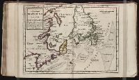
Forty-two new maps of Asia, Africa, and America ... : all engrav’d, according to the latest
Image Count:
1
Alternative Title:
Newfoundland, New Scotland, &c
Description:
In pencil on verso: 38. and Table of contents for maps 2-20 in section "America" misnumbered.
Subject (Geographic):
New Brunswick --Maps, Newfoundland --Maps --Early works to 1800, and Nova Scotia --Maps --Early works to 1800
Subject (Name):
Nicholson, John, d. ca. 1717, bookseller
Subject (Topic):
Atlases --Early works to 1800
Collection Created:
London : Printed for J. Nicholson ..., 1716 ...
Found in:
Beinecke Rare Book and Manuscript Library > A new map of Newfound land, New Scotland the isles of Breton, Anticoste, St, Iohns &c. together with the fishing bancks
Call Number:
1976 1233
Collection Title:
Forty-two new maps of Asia, Africa, and America ... : all engrav’d, according to the latest
Image Count:
1
Alternative Title:
North America
Description:
In pencil on verso: 34. and Table of contents for maps 2-20 in section "America" misnumbered.
Subject (Geographic):
North America --Maps --Early works to 1800
Subject (Name):
Nicholson, John, d. ca. 1717, bookseller
Subject (Topic):
Atlases --Early works to 1800
Collection Created:
London : Printed for J. Nicholson ..., 1716 ...
Found in:
Beinecke Rare Book and Manuscript Library > A new map of North America according to the newest observations
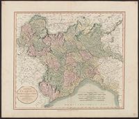
Creator:
Call Number:
401 1811
Container / Volume:
BRBL_00233
Image Count:
1
Resource Type:
Maps, Atlases & Globes
Description:
Hand colored. Stamp: Karpinski-von Wieser Map Collection. Label: 17., Meridian: Greenwich., and Relief shown by hachures.
Subject (Geographic):
Genoa (Italy : Province)--Maps, Milan (Italy : Province)--Maps, Piedmont (Italy)--Maps, and Savoy (France and Italy)--Maps
Found in:
Beinecke Rare Book and Manuscript Library > A new map of Piedmont, the duchies of Savoy and Milan, and the republic of Genoa, with their subdivisions : from the latest authorities / by John Cary.
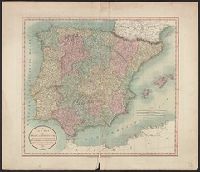
Creator:
Call Number:
39 1801
Container / Volume:
BRBL_00186
Image Count:
1
Resource Type:
Maps, Atlases & Globes
Description:
Appeared in Cary's new universal atlas, London, 1808. and Relief shown pictorially.
Subject (Geographic):
Portugal--Maps and Spain--Maps
Subject (Name):
Cary, John, ca. 1754-1835. Cary's new universal atlas and Hughes, Thomas Lowe,--1925---Ownership
Found in:
Beinecke Rare Book and Manuscript Library > A new map of Spain and Portugal : divided into their respective kingdoms and provinces from the latest authorities / by John Cary, engraver.
Call Number:
1976 1233
Collection Title:
Forty-two new maps of Asia, Africa, and America ... : all engrav’d, according to the latest
Image Count:
1
Alternative Title:
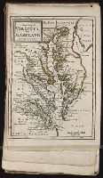
Virginia and Maryland
Description:
In pencil on verso: 41. and Table of contents for maps 2-20 in section "America" misnumbered.
Subject (Geographic):
Maryland --Maps --Early works to 1800 and Virginia --Maps --Early works to 1800
Subject (Name):
Nicholson, John, d. ca. 1717, bookseller
Subject (Topic):
Atlases --Early works to 1800
Collection Created:
London : Printed for J. Nicholson ..., 1716 ...
Found in:
Beinecke Rare Book and Manuscript Library > A new map of Virginia, and Maryland
Call Number:
Zc90 +744do
Collection Title:
An account of the countries adjoining to Hudson's Bay, in the North-west part of America
Image Count:
1
Description:
Preceding title page. and Teaching resource: Professor John Mack Faragher, History 141: The American West.
Subject (Geographic):
Great Lakes (North America), Northwest Coast of North America, Northwest Passage, and Northwest, Canadian --Description and travel
Subject (Name):
Fuentes, Bartolome de, 17th cent, Hudson’s Bay Company, and Middleton, Christopher, d. 1770
Subject (Topic):
Fur trade --Canada and Indians of North America --Canada
Collection Created:
London : Printed for J. Robinson, 1744
Found in:
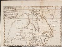
Beinecke Rare Book and Manuscript Library > A new map of part of North America from the latitude of 40 to 68 degrees. Including the late discoveries made on board the Furnace Bomb Ketch in 1742. And the western rivers & lakes falling into Nelson River in Hudson's Bay, as described by Joseph La Fran
Branch:v1.61.6 ,Deployed:2024-06-12T09:55:33-04:00