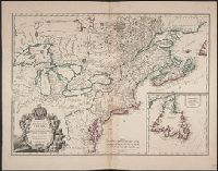
1st state. Distinguishing feature of 1st state: "Area south of Lake Erie shows Ohio River running east to west, no forts" (Pedley 212)., Includes "Supplément pour l'isle de Terre-Neuve.", and Shows British colonies as far south as the present state of North Ca
Publisher:
chés l'Auteur,
Subject (Geographic):
Canada--Maps--Early works to 1800, New France--Maps--Early works to 1800, Newfoundland and Labrador--Maps--Early works to 1800, and United States--Maps--Early works to 1800
Subject (Name):
Argenson, Marc-Pierre de Voyer, comte d', 1696-1764. dedication
Subject (Topic):
British--America--Maps--Early works to 1800 and French--America--Maps--Early works to 1800
Haussard, E Robert de Vaugondy, Didier, 1723-1786 Robert de Vaugondy, Gilles, 1688-1766. Atlas universel
Published / Created:
1756
Call Number:
34 1756
Container / Volume:
BRBL_00090
Image Count:
1
Resource Type:
Maps, Atlases & Globes
Alternative Title:
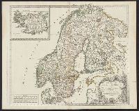
Islande divisée en ses 4 parties principales. and Suede & Norwege
Description:
Appears in G. Robert de Vaugondy's Atlas universel., Covers Sweden, Norway, and Finland., Has watermark., Includes ornamental cartouche and inset of "L'Islande divisée en ses 4 parties principales.", Relief shown pictorially, and Stamped on verso: Suede & Norwege