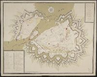
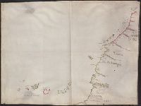
Color: Original pen and water color drawing, blue and green., Key in upper right hand corner., and Military map of the Fjord of Vigo on the Galician coast, with the fortresses of Bayona and Vigo on the south bank, Vigo being located further inland. The outlines of the land and of the islands in the fjord are pin-holed for tracing purposes. Buildings representing residential areas, chapel covents, etc. are drawn in full whereas the two fortresses are depicted as ground-plan.
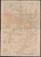
"Groupe de Ganevas de Tir ; 27 Julliet 1918 ; secret"., Pencil and color annotations on printed base map., Relief shown by contours and spot heights., and Shows infantry routes, roads not to be used by infantry, and objectives.
Publisher:
s.n.],
Subject (Geographic):
Picardy (France)--Maps
Subject (Name):
United States.--Army.--Division, 32nd--Maps
Subject (Topic):
Aisne, Battle of the, France, 1918--Maps and World War, 1914-1918--Regimental histories--United States--Maps
Backed with paper., Copied from plate 9 in Alexandre de Humboldt's Atlas geographique et physique du royaume de la Nouvelle-Espagne., Imperfect: mutilated along folds., Relief shown by hachures., and Title devised by cataloger.
Subject (Geographic):
Veracruz-Llave (Mexico : State)
Subject (Name):
Humboldt, Alexander von, 1769-1859. Atlas geographique et physique du royaume de la Nouvelle-Espagne.