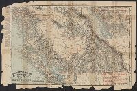
"Engraved and indexed for use with the Rand McNally commercial atlas and marketing guide.", Date inferred from 1950 population table of counties., and Indexed.
Publisher:
The Company,
Subject (Geographic):
Colorado--Administrative and political divisions--Maps and Colorado--Maps
In lower right: 534506. and Includes indexes, and maps of "Kings Canyon and Sequoia national parks," "Yosemite National Park," and "Fresno, Stockton, Yosemite, Kings Canyon, and Sequoia Region, Calif.," and ill. on verso.
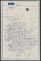
Copyright: Rand McNally & Company., In lower right: Y.3897., Includes inset of "Pacific Palisades.", and Indexes, "Los Angeles and vicinity (recreational map)," (scale [ca. 1:323,136]), and ill. on verso.
Publisher:
Rand McNally & Co.,
Subject (Geographic):
Los Angeles (Calif.)--Maps and Los Angeles Metropolitan Area (Calif.)--Maps
Subject (Name):
Union Oil Company of California
Subject (Topic):
Roads--California--Los Angeles Metropolitan Area--Maps and Streets--California--Los Angeles--Maps
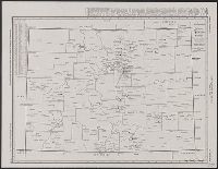
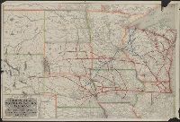
Rand, McNally & Co.'s indexed indexed atlas of the world map of British Columbia
Description:
"British Columbia Railroads"--Lower right corner., "Copyright, 1895, by Rand, McNally & Co.", "Rand, McNally & Co.'s New Business Atlas Map of British Columbia.", Inset: Northern part of British Columbi, and Railroads; settlements; mining districts and divisions.
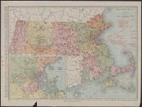
Includes index to counties and principal cities, list of Massachusetts railroads, and steamship routes., Inset: "Environs of Boston.", Ms. notes: some cities circled in black ink., and Relief shown by hachures and spot heights.
Publisher:
Rand McNally & Co.,
Subject (Geographic):
Massachusetts--Maps
Subject (Topic):
Railroads--Massachusetts--Maps and Roads--Massachusetts--Maps
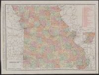
Rand, McNally & Co.'s new business atlas map of Missouri.
Description:
At bottom: Rand, McNally & Co.'s new business atlas map of Missouri. Copyright 1911 ... Copyright 1903 by Rand, McNally & Co., Includes indexes and inset of southeastern Missouri., Relief shown by hachures., and Shows railroads.
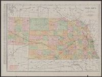
Rand McNally & Co.'s new business atlas map of Nebraska.
Description:
Below scale: Rand McNally & Co.'s new business atlas map of Nebraska., Indexed., Library's copy originally appeared in cover (17 x 11 cm.); back cover remains attached, showing advertisement for "Rand, McNally & Co.'s series of indexed pocket maps.", Relief shown by hachures., and Shows counties, railroads, and drainage.
Rand McNally & Co.'s new business atlas map of Nebraska.
Description:
Below scale: Rand McNally & Co.'s new business atlas map of Nebraska., Indexed., Relief shown by hachures., and Shows counties, railroads, and drainage.