Coastal chart., Imperfect: Mutilated with loss of information., Includes text: "Instructions for the coast of South Carolina, Georgia, and the coast of St. Augustin"., and Oriented with north to the left.
Publisher:
W. Mount and T. Page,
Subject (Geographic):
Atlantic Coast (South Atlantic States)--Maps., Georgia--Maps--Early works to 1800., and South Carolina--Maps--Early works to 1800.
Subject (Topic):
Coastwise navigation--Atlantic Coast (South Atlantic States)
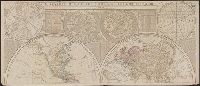
From Jefferys's The American atlas ... London : Printed and sold by R. Sayer and J. Bennett, 1776., Hand col. Sheet measures 55.1 x 73.5 cm. Stamped no. on verso: 12. Cross Collection no. 160., and Relief shown pictorially. Depths shown by soundings.
Publisher:
By Thomas Jefferys, geographer to the King, printed for Robt. Sayer & Jno. Bennett,
Subject (Geographic):
Newfoundland, Island of (N.L.)--Maps--Early works to 1800
Subject (Name):
Cook, James, 1728-1779, Jefferys, Thomas, d. 1771. American atlas, Lane, Michael, fl. 1768-1784, and Robert Sayer and John Bennett (Firm)
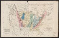
Subject: Map of the central part of the United States showing the middle Atlantic states, and the Ohio River Valley region. Includes anecdotes on the different Indian nations and the lands. Shows dates of settlements and agreements, locations of quarries,
Alternative Title:
Middle British colonies.
Description:
Differs from other copies in extension of the Connecticut River north beyond "Great Falls." Differs also in coloration of boundaries: Ohio River is colored as a boundary: Pennsylvania is shown as extending north to Lake Ontario, etc. and Shows "West longitude
Publisher:
Printed for Carington Bowles,
Subject (Geographic):
Canada--Maps--Early works to 1800, Middle Atlantic States--Maps--Early works to 1800, Northeastern States--Maps--Early works to 1800, and Ohio River Valley--Maps--Early works to 1800
Subject (Name):
Bowles, Carington, 1724-1793, publisher
Subject (Topic):
British--America--Maps--Early works to 1800 and Chron.--1771
"The seat of the war in the middle British colonies, containing Virginia, Maryland, the Delaware counties, &ca.", From the author's The American military pocket atlas. [1776], Hand colored., Inset: A sketch of the upper parts of Canada., and Relief shown pictoria
Publisher:
Printed for R. Sayer & J. Bennett, map, chart & printsellers,
From An atlas of the United States of North America ... London : Published by Simpkin & Marshall and Thomas Wardle, Philadelphia, 1832. and Sheet measures 27.3 x 42 cm. Bound with plate "Geological sections of the United States." Cross Collection no. 187.
Publisher:
I.T. Hinton & Simpkin & Marshall,
Subject (Geographic):
United States--Maps
Subject (Name):
Fenner, Sears & Co, Hinton, Isaac Taylor, 1799-1847, and Simpkin and Marshall
"E.L.B. & R.N.C. 1878 no. 2.", Includes inset map of Magadascar., Issued to accompany: A sketch of the modern languages of the East Indies / by Robert Needham Cust. 1878., and Relief shown by hachures and spot heights.
Publisher:
Stanford's Geogl. Estabt.,
Subject (Geographic):
Southeast Asia--Languages--Maps.
Subject (Name):
Cust, Robert Needham, 1821-1909. Sketch of the modern languages of the East Indies.