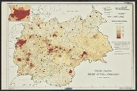
United States. Office of Strategic Services. Research and Analysis Branch
Published / Created:
1945
Call Number:
36eb 1945B
Container / Volume:
BRBL_00127
Image Count:
1
Resource Type:
Maps, Atlases & Globes
Description:
"No. 6381-R & A, OSS, 28 April 1945.", "Population data compiled in the Department of State, Division of Geography and Cartography.", and Inset: [Düsseldorf-Münster area].
Publisher:
R & A, OSS,
Subject (Geographic):
Europe, Central--Population--Maps and Germany--Population--Maps
United States. Office of Strategic Services. Research and Analysis Branch
Published / Created:
1945
Call Number:
36eb 1939
Container / Volume:
BRBL_00127
Image Count:
1
Resource Type:
Maps, Atlases & Globes
Description:
"No. 6357 - R & A, OSS, 10 April 1945.", "Population data compiled in the Department of State, Division of Geography and Cartography.", and Inset: [Düsseldorf-Münster area]
Publisher:
R & A, OSS,
Subject (Geographic):
Europe, Central--Population--Maps and Germany--Population--Maps
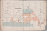
[Maury map collection ; ser. F5] and Sperm and right whale
Description:
"By authority of Commo: Charles Morris U.S.N., Chief of Bureau of Ordnance and Hydrography, 1853.", "Series F.", Copy imperfect: Sectioned vertically in half, sections mounted on cloth to form 1 sheet., DLC, and The whale chart was released as series F a part of
Publisher:
United States Hydrographical Office,
Subject (Name):
Endicott & Co. (New York, N.Y.), Maury, Matthew Fontaine, 1806-1873. Wind and current charts, Morris, Charles, 1784-1856, United States. Bureau of Ordnance and Hydrography, United States. Hydrographic Office, and Wyman, R. H. (Robert Harris), 1822-1882
Subject (Topic):
Right whales--Maps, Sperm whale--Maps, Whales--Behavior--Maps, and Whaling--Maps