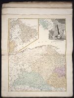
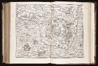
The English pilot: describing the sea-coasts, capes, head-lands, rivers, bays, roads, havens
Image Count:
1
Description:
Most maps numbered in pencil on verso, some on recto.
Subject (Geographic):
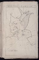
Atlantic Ocean --Maps --Early works to 1800 and Boston Harbor (Mass.) --Maps --Early works to 1800
Subject (Topic):
Navigation --Early works to 1800, Pilot guides --Atlantic Coast (U.S.) --Early works to 1800, and Pilot guides --Caribbean Area --Early works to 1800
Collection Created:
London : Printed for John Thornton, at the sign of the England, Scotland, and Ireland, in the Minories, and Richard Mount, at the Postern on Tower-Hill, 1698London : Printed for John Thornton, at the sign of the England, Scotland, and Ireland, in the Minories, and Richard Mount, at the Postern on Tower-Hill, 1698
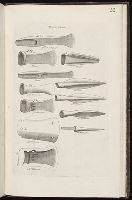
Album containing 122 engravings by Stukeley, many in proof, assembled by the artist himself. Contents include 85 engravings from Itinerarium Curiosum and 23 from Stonehenge, a Temple Restor’d to the British Druids.
Description:
Plate numbered 122.
Subject (Geographic):
Great Britain --Antiquities --Early works to 1800
Subject (Topic):
Bronze age--England, Celtic antiquities, Tools--Great Britain, and Weapons--Great Britain