Covers also town of North Andover and a portion of the City of Lawrence, Massachusetts., Imperfect: Mutilated with slight loss of text. Mounted on board., Relief shown by hachures., and Shows buildings with names of property owners.
Publisher:
Pendleton's Lithogy.,
Subject (Geographic):
Andover (Mass. : Town)--Buildings, structures, etc.--Maps., Andover (Mass. : Town)--Maps., Lawrence (Mass.)--Maps., and North Andover (Mass. : Town)--Maps.
Subject (Name):
Pendleton's Lithography.
Subject (Topic):
Landowners--Massachusetts--Andover (Town)--Maps., Landowners--Massachusetts--Lawrence--Maps., Landowners--Massachusetts--North Andover (Town)--Maps., Real property--Massachusetts--Andover (Town)--Maps., Real property--Massachusetts--Lawrence--Maps., and Real property--Massachusetts--North Andover (Town)--Maps.
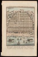
Bird's-eye view of Canton, now Guangzou, China; relief shown pictorially., From: Navigantium atque itinerantium bibliotheca ... / John Harris. -- London : T. Woodward, 1744-1748., In upper right-hand corner: Vol. 1. pa. 359., and Indexed for points on interest.
Publisher:
[T. Woodward],
Subject (Geographic):
Guangzhou (China)--Maps--Early works to 1800.
Subject (Name):
Harris, John, 1667?-1719. Navigantium atque itinerantium bibliotheca.
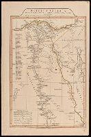
"9"--Manuscript note in upper right corner of sheet. Accompanied by: Title page: A complete body of ancient geography by Mons. D'Anville ... London : James Whittle and Richard Holmes Laurie, 1818 (1 sheet)., Includes index., Includes six bar scales., Prime meridian: Ferro., Relief shown by hachures., and Watermark.
Publisher:
Laurie & Whittle,
Subject (Geographic):
Egypt--Administrative and political divisions--Maps. and Egypt--Maps.
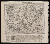
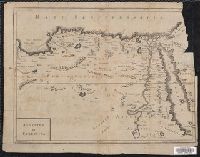
"Octavo, Vol. 2, p. 371" in lower left corner., Imperfect: upper right corner mutilated, with some loss of text. Reinforced on verso with strips of manuscript waste., Relief shown pictorially., and Shows boundaries, rivers and principal settlements.
Publisher:
[publisher not identified],
Subject (Geographic):
Egypt--Historical geography--Early works to 1800--Maps., Egypt--Maps--Early works to 1800., Libya--Historical geography--Early works to 1800--Maps., and Libya--Maps--Early works to 1800.
"Cum gratia et privil. S.R.I. Vicari atg., in partibg. Rheni, Suevice, et juris Franconici.", Has watermark., Includes ornamental cartouche and text., and Relief shown pictorially.
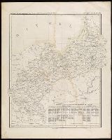
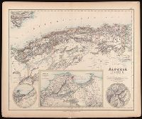
Algérie, Algiers and environs on an enlarged scale., Constantine and environs., and Oran and environs.
Description:
Appears in: Royal illustrated atlas of modern geography. London ; Edinburgh : A. Fullarton and Co., [1872?]. (pl. XLVI)., Inset maps: 1. Algiers and environs on an enlarged scale. Scale [ca. 1:1,050,000] -- 2. Constantine and environs -- 3. Oran and environs., Relief shown by hachures., and Stamp in upper right corner: 46.
Publisher:
A. Fullarton and Co.,
Subject (Geographic):
Algeria--Maps.
Subject (Name):
A. Fullarton & Co., A. Fullarton & Co. Royal illustrated atlas of modern geography., and Edward Stanford Ltd.
Appears in various eds. of Atlas geographicus maior., Includes German text relating to English and French territorial claims., Place names and descriptive notes in English., Prime meridian: Ferro and London., Relief shown pictorially., and Sheet measures 47.5 x 51 cm.
Publisher:
[Homann Erben],
Subject (Geographic):
North America--Maps--Early works to 1800. and United States--History--French and Indian War, 1755-1763--Maps--Early works to 1800.
Subject (Name):
Anville, Jean Baptiste Bourguignon d', 1697-1782. and Homann Erben (Firm). Atlas geographicus maior.