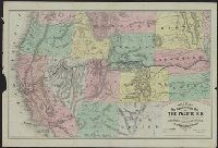
Map of the states and territories from the Mississippi River to the Pacific Ocean
Description:
"Entered according to act of Congress in the year 1867 by G.W. & C.B. Colton ... ", Also shows locations of Indian tribes., Includes text., Prime meridians: Greenwich and Washington., and Relief shown by hachures and spot heights.
Publisher:
G.W. and C.B. Colton,
Subject (Geographic):
Overland Trails--Maps and West (U.S.)--Maps
Subject (Topic):
Indians of North America--Maps and Railroads--West (U.S.)--Maps
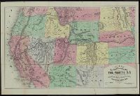
Map of the states and territories from the Mississippi River to the Pacific Ocean
Description:
"Entered according to act of Congress in the year 1874 by G.W. & C.B. Colton ... ", Also shows locations of Indian tribes., Includes text., Prime meridians: Greenwich and Washington., and Relief shown by hachures and spot heights.
Publisher:
G.W. and C.B. Colton,
Subject (Geographic):
Overland Trails--Maps and West (U.S.)--Maps
Subject (Topic):
Indians of North America--Maps and Railroads--West (U.S.)--Maps
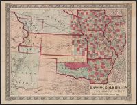
Johnson's new railroad and county copper plate map of Kansas gold region and the Great West, from the latest and best authorities, New, and New rail road and county copper plate map of Kansas gold region and the Great West, from the latest and best authorities
Description:
"Entered according to act of Congress in the year 1859 by A.J. Johnson in the clerks office of the district court of the United States for the southern district of New, Includes notes., Prime meridian: Washington., and Relief shown by hachures and spot heights.
Publisher:
Johnson & Browning,
Subject (Geographic):
Kansas--Maps and West (U.S.)--Maps
Subject (Name):
Johnson & Browning
Subject (Topic):
Colorado--Gold discoveries--Maps, Gold mines and mining--Colorado--Maps, and Railroads--West (U.S.)--Maps
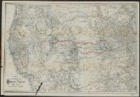
Imperfect: Tear in lower left., Relief shown by hachures., and Shows western states, drainage, cities and towns, and the railroads with emphasis on the main line.
Publisher:
[G.W. & C.B. Colton],
Subject (Name):
Union Pacific Railway Company and Union Pacific Railway Company--Maps
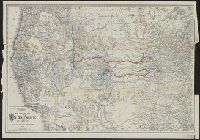
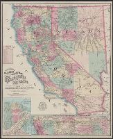
Map of the city of San Francisco, California., Map of the Great National Pacific Railroads., and Topographical railroad and county map of the states of California and Nevada
Description:
"Entered according to act of Congress A.D. 1868 by Frey & Nell in the clerks office of the district court of the United States for the southern district of New York." and Includes insets of "Map of the city of San Francisco, California" and "Map of the Great National Pacific Railroads," distance list, and difference of time chart.
Publisher:
A.C. Frey & Co. ; and General agents for California, A. Roman & Co.,
Subject (Geographic):
California--Maps, Nevada--Maps, and San Francisco (Calif.)--Maps
Subject (Name):
A. Roman & Co, A.C. Frey & Co, and Ferd. Mayer & Co
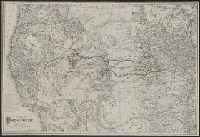
New trans-continental map of the Pacific R.R. and routes of overland travel to Colorado, Nebraska, the Black Hills, Utah, Idaho, Nevada, Montana, California and the Pacific coast
Description:
"Entered according to act of Congress in the year 1876 by H.T. Williams ...", Advertisements and text on verso., In lower margin: Am. Photo-Lithographic Co. N.Y. (Osborne's Process)., Relief shown by, and Shows completed and projected railroads and stage routes.
New trans-continental map of the Pacific R.R. and routes of overland travel to Colorado, Nebraska, the Black Hills, Utah, Idaho, Nevada, Montana, California, and the Pacific coast
Description:
"Entered according to act of Congress in the year 1877 by H.T. Williams ...", Advertisements, time tables, fare schedules, and text on verso., and Relief shown by hachures.