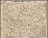
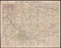
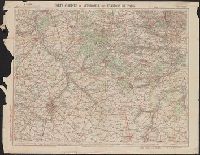
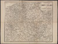
"Gravé et imprime par Charaire, à Sceaux." and Shows cities, towns, roads, waterways, and the location of troops and fortifications along the French front.
"Gravé et imprime par Charaire, à Sceaux." and Shows cities, towns, roads, waterways, and the location of troops and fortifications along the French front.
Nouvelle carte de France à l'usage des cyclistes et automobiles.
Description:
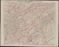
"7-09"--Bottom right corner., "No. 10"--Upper left corner., No. 10 in series "Nouvelle carte de France à l'usage des cyclistes et automobiles.", Relief shown by spot heights., Scale of kilometers., and Shows the France-Comté region of eastern France and French speaking western Switzerland from Montbeliard, France in the north to Geneva, Switzerland in the south, and west from Macon, France to Berne, Switzerland in the east. Includes the Jura Mountains, Lake Geneva and Lake of Neuchatel.
Publisher:
A. Taride,
Subject (Geographic):
Franche-Comté (France)--Maps, Jura Mountains (France and Switzerland)--Maps, and Switzerland, French-speaking--Maps
Subject (Name):
Bineteau, P
Subject (Topic):
Bicycle trails--France--Franche-Comté--Maps, Bicycle trails--Jura Mountains (France and Switzerland)--Maps, Bicycle trails--Switzerland, French-speaking--Maps, Roads--France--Franche-Comté--Maps, and Roads--Jura M