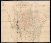
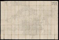
BEIN 71 1820B: Dissected and mounted on linen., Relief shown by hachures., "Additions to 1814" underneath "humble" in title., and "Additions to 1802" follows publication statement at bottom of map.
Publisher:
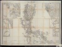
Published Jan. 1, 1795 by A. Arrowsmith, No. 10 Soho Square
Campbell, E. Simms (Elmer Simms), 1906-1971, creator
Call Number:
BrSides Double Folio 2016 34
Image Count:
1
Resource Type:
cartographic image
Description:
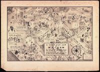
BEIN BrSides Double Folio 2016 34: Mounted on board. Stamp in upper left corner, "Manhattan." Scant manuscript annotations at bottom. and North oriented towards the lower right.
Subject (Geographic):
Harlem (New York, N.Y.), New York (State), and New York
Subject (Name):
Cotton Club., Connie’s Inn (New York, N.Y.), Small’s Paradise (Nightclub : Harlem, New York, N.Y.), Lafayette Theater (New York, N.Y. : 132nd Street), Club Hot-Cha (New York, N.Y.), Yeah Man (Nightclub : New York, N.Y.), Tillie's (Nightclub : New York, N.Y.), Radium Club (New York, N.Y.), Calloway, Cab, 1907-1994, Bentley, Gladys, Robinson, Bill, 1878-1949, and Tucker, Snakehips
Subject (Topic):
Social life and customs, African American neighborhoods, Nightclubs, and Harlem Renaissance
Bookplate of Peter E. Keyser. Bookplate signed by P.D. Keyser ... Philadelphia, Pa., Manuscript label on cover: A-24., and Includes ninety-three blanks pages at end.
Subject (Geographic):
Germantown (Philadelphia, Pa.), Pennsylvania, and Philadelphia.
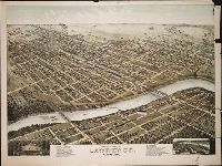
Print shows a bird's eye view of Lawrence, Kansas in 1880 numbered with 33 points of interest and indexed under the title "The New," to left of print's title caption; and, in the lower right, a map insert labeled, "Lawrence in 1855" numbered with 20 points of interest and indexed under the title "The Old," to right of the print's title caption
Description:
BEIN BrSides Zc39 880mo copy 1: Imperfect: lower right corner of sheet, upper right margin, and small section of right hand side broken off; a tear across sheet from right to center about one third up sheet. On sheet 62 x 82 cm., BEIN BrSides Zc39 880mo copy 2: On sheet 64 x 82 cm., Title from caption below image., Pictorial representation., and "Copyright by D.D. Morse, 1880."
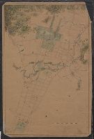
Covers area between Eunice Street and Euclid Avenue [that is, Grizzly Peak Boulevard]., Cadastral map., and Coordinates not present on map and are approximated.
BEIN 28 1852A: Covers removed and classed separately as 28 1852AA. Bookseller's label on inside front cover: Cellar Book Shop ... Detroit, Mich., BEIN 28 1852B: Covers removed and classed separately as 28 1852BA. Bookseller's label on inside front cover: Cellar Book Shop ... Detroit, Mich., BEIN 28 1852C: Covers removed and classed separately as 28 1852CA. Bookseller's label on inside front cover: Cellar Book Shop ... Detroit, Mich., Relief shown by hachures. Depths shown by soundings., Prime meridian: Madrid., In upper margin: Diccionario geográfico-estadístico-histórico ; Atlas de España y sus posesiones de ultramar., Cover title: Atlas de España y sus posesiones de ultramar / por D. Francisco Coello., Sheets titled: Posesiones de Oceania -- Primera hoja central -- Segunda hoja central., "Grabado en Madrid bajo la direccion de D. Juan Noguera. El contorno y la topografia por Desbuissons y Raynaud, la letra por Bacot"--Primera hoja., "Grabado en Madrid bajo la direccion del autor. El contorno por Leclercq, la topografia por Desbuissons, la letra por Bacot"--Segunda hoja and posesiones sheet., Includes text about demography and economy., and Price and subscription information on covers.
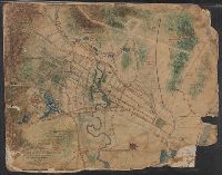
Imperfect: mutilated., Title devised by cataloger., North oriented towards the right., Color: green with blue and red detail., and Coordinates not present on map and are approximated.
Map of Horse Railroad, Westville, and part of New Haven
Description:
Imperfect: mutilated., Map attributed to Donald Grant Mitchell., Backed with paper., Relief shown by hachures., "Scale of five inches to mile.", Color: green with blue and red detail., and Coordinates not present on map and are approximated.