Skip to search
Skip to main content
Skip to first result
Search
You Searched For
Format
cartographic
Genre
Illustrations
Resource Type
Maps, Atlases & Globes
New Search
Search Results
Creator:
Call Number:
1973 Folio 103
Collection Title:
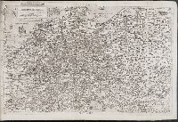
De Nieuwe groote lichtende zee-fakkel ...
Image Count:
1
Resource Type:
Maps, Atlases & Globes
Subject (Geographic):
Madagascar
Subject (Topic):
Atlases and Nautical charts.
Collection Created:
tAmsterdam, Johannes van Keulen, 1753-81
Found in:
Beinecke Rare Book and Manuscript Library > Madagascar
Published / Created:
1569?]
Call Number:
EE23 569L
Collection Title:
[Geografia tavole moderne di geografia de la maggior parte del mondo / di diversi avtori racoolte
Image Count:
1
Resource Type:
Maps, Atlases & Globes
Publisher:
n.p
Collection Created:
[Roma, 1569?]
Found in:
Beinecke Rare Book and Manuscript Library > Nova Germaniae Descriptio
Creator:
Published / Created:
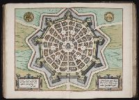
1593
Call Number:
1975 Folio 41
Collection Title:
Civitates orbis terrarvm ...
Image Count:
1
Resource Type:
Maps, Atlases & Globes
Subject (Geographic):
Palmanova (Italy) --Buildings, structures, etc. --Designs and plans
Subject (Name):
Hierat, Anton, fl.1597-1627, Hogenberg, Abraham, fl. 1608-1653, and Hogenberg, Franz, d. 1590?
Subject (Topic):
Cities and towns, Medieval
Collection Created:
[Coloniae Agrippinae, 1572]-1618
Found in:
Beinecke Rare Book and Manuscript Library > Palma
Call Number:
1977 +392
Collection Title:
A survey of the cities of London and Westminster : containing the original, antiquity, increase
Image Count:
1
Resource Type:
Maps, Atlases & Globes
Description:
Plate between p. 82-83.
Subject (Geographic):
London (England)--History
Collection Created:
London : Printed for A. Churchill, J. Knapton, R. Knaplock, J. Walthoe [and 6 others], 1720
Found in:
Beinecke Rare Book and Manuscript Library > Part of Aldgate Ward
Creator:
Published / Created:
1748
Call Number:
ZZ35 5 1
Image Count:
1
Resource Type:
Maps, Atlases & Globes
Abstract:
Manuscript map in blue and red ink depicting the original nine squares. This map is possibly the original drawing by James Wadsworth, drawn from actual surveys.
Description:
Pen-and-ink and watercolor with linen backing.
Subject (Geographic):
New Haven (Conn.) --Maps --Early works to 1800
Found in:
Beinecke Rare Book and Manuscript Library > Plan of the city of New Haven taken in 1748
Call Number:
1977 +392
Collection Title:
A survey of the cities of London and Westminster : containing the original, antiquity, increase
Image Count:
1
Resource Type:
Maps, Atlases & Globes
Description:
Plate between p. 50-51.
Subject (Geographic):
London (England)--History
Collection Created:
London : Printed for A. Churchill, J. Knapton, R. Knaplock, J. Walthoe [and 6 others], 1720
Found in:
Beinecke Rare Book and Manuscript Library > Shoreditch, Norton Folgate, and Crepple Gate without, taken from the last survey with corrections
Branch:v1.61.8 ,Deployed:2024-06-20T11:14:48-04:00