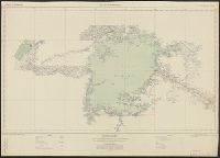
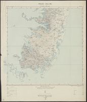
Great Britain. War Office. General Staff. Geographical Section. [G.S.G.S.], GSGS (Series) ; 2639., Pemba Island, Pemba Island. Chake Chake [cartographic material]., Pemba Island. Sheet 1 [cartographic material]., and Pemba Island. Sheet 2 [cartographic material].
Description:
Includes index to adjoining sheet. and Relief shown by contours.
Publisher:
Ordnance Survey Office,
Subject (Geographic):
Pemba Island (Tanzania)--Maps
Subject (Name):
Great Britain. War Office. General Staff. Geographical Section
Has watermark., Includes "Admonitio" and 4 bar scales., Prime meridian: Ferro., Relief shown pictorially., Sheet measures 55.7 x 67.2 cm., and Shows east coast of Brazil.
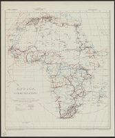
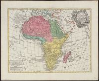
Africa distinguished into its principall parts viz. Barbary, Biledulgerid, Egypt, Zaara or the Desart, the Country of the Negroes, Guinea, Nubia, Abissinea, Zanguebar, Congo, Monomotapa, Caffrares, the Islands of the Canaries, Cape Verd, St. Thomas, Madagascar or St. Lawrence in which are observed the empires, monarchies, kingdomes, states and peoples, which at present inhabite Africa
Description:
Ferro meridian., No. 56 of 69 maps bound together in composite atlas., Relief shown pictorially., Scale [ca 1:34 000 000]., and To the most serene and most sacred majesty of Charles II, by the grace of God, king of Great Brittain, France, and Ireland, this map of Africa is humbly dedicated and presented by your majesties loyal subject and servant, William Berry.
Publisher:
Sold by William Berry at the sign of the globe between Charing Cross and White-Hall
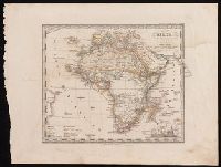
In upper right corner: Atlante scol. di Stieler, No. XVIII., Prime meridian: Ferro., and Relief shown pictorially.
Publisher:
Giusto Perthes,
Subject (Geographic):
Africa--Maps
Subject (Name):
Justus Perthes (Firm : Gotha, Germany), publisher, Münster, H. F., publisher, and Stieler, Adolf, 1775-1836. Kleiner Schulatlas über alle Theile der Erde. Italian.