Skip to search
Skip to main content
Skip to first result
Search
You Searched For
Date
Unknown
Extent of Digitization
Partially digitized
Format
cartographic
Date Created
[Missing]
New Search
Search Results
Creator:
Call Number:
1976 Folio 110
Collection Title:
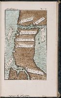
The mariners mirrovr wherin may playnly be seen the courses, heights, distances, depths, sounding
Image Count:
1
Resource Type:
Maps, Atlases & Globes
Description:
Theodor de Bry, Sculp.
Subject (Geographic):
Bordeaux (France) and Garonne River (Spain and France)
Collection Created:
[London, J. Charlewood? 1588]
Found in:
Beinecke Rare Book and Manuscript Library > The sea coastes of the landes of Poyctou and Bordeaux ...as they shew and appeare, when you sayle there alongst betweene Picquelier and the River of Bordeaux called the Garonne
Call Number:
Lxe 784m
Collection Title:
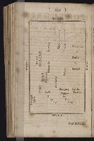
Geography made easy : being a short, but comprehensive system of that very useful and agreeable
Image Count:
1
Resource Type:
Books, Journals & Pamphlets
Description:
Imperfect: engraving of map not completed.
Subject (Name):
Doolittle, Amos, 1754-1832
Subject (Topic):
Geography
Collection Created:
New Haven : Meigs, Bowen & Dana, [1784]
Found in:
Beinecke Rare Book and Manuscript Library > The situation of [the] kingdoms and states [of Europe]
Call Number:
Taylor 136
Collection Title:
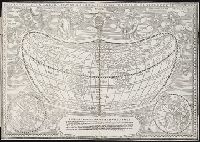
La cosmographia, y geographia del S. Hieronimo Girava Tarragones : en la qual se contiene la
Image Count:
1
Description:
Map has several small holes along fold lines. and On verso: map has several small marks ranging from yellow to brown and gray.
Subject (Name):
Miranda, Giovanni de, 16th cent
Subject (Topic):
Discoveries in geography --Early works to 1800, Discoveries in geography --Spanish, Maps --Early works to 1800, and Maps in books --1570
Collection Created:
En Venetia : Por Iordan Zileti, y su companero,
Found in:
Beinecke Rare Book and Manuscript Library > Typo de la carta cosmographica de Gaspar Vopellio Medeburgense
Creator:
Call Number:
Taylor 256
Collection Title:
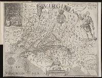
A map of Virginia : vvith a description of the covntrey, the commodities, people, government and
Image Count:
1
Abstract:
Inset depicting Powhatan.
Subject (Geographic):
Virginia --History --Colonial period, ca. 1600-1775
Subject (Topic):
Voyages and travels
Collection Created:
At Oxford : Printed by Joseph Barnes, 1612
Found in:
Beinecke Rare Book and Manuscript Library > Virginia discouered and described by Captayn John Smith
Call Number:
1973 Folio 114
Collection Title:
The English pilot: describing the West-India navigation, from Hudson's-Bay to the river Amazones
Image Count:
1
Resource Type:
Maps, Atlases & Globes
Subject (Geographic):
Atlantic Ocean --Maps --Early works to 1800, Maryland --Maps --Early works to 1800, New Jersey --Maps --Early works to 1800, and Virginia --Maps --Early works to 1800
Subject (Topic):
Navigation --Early works to 1800, Pilot guides --Atlantic Coast (U.S.) --Early works to 1800, and Pilot guides --Caribbean Area --Early works to 1800
Collection Created:
London : Printed for W. and J. Mount, T. Page and son, on Tower-Hill, MDCCLIX [1759]
Found in:
Beinecke Rare Book and Manuscript Library > Virginia, Maryland, Pennsilvania, east & west New Jarsey
Call Number:
Zc86 925te
Collection Title:
A journey to Alaska in the year 1868 : being a diary of the late Emil Teichmann / edited with an
Image Count:
1
Resource Type:
Books, Journals & Pamphlets
Publisher:
George Philip & Son, Ltd
Subject (Geographic):
Northwest Coast of North America--Description and travel. and Sitka (Alaska)--Description and travel
Collection Created:
Kensington [England] : Privately printed at the Cayme Press, 1925
Found in:
Beinecke Rare Book and Manuscript Library > Voyage of the "Ocean Queen," Victoria to Sitka, 1868
Branch:v1.61.8 ,Deployed:2024-06-20T11:15:04-04:00