Skip to search
Skip to main content
Skip to first result
Search
You Searched For
Extent of Digitization
Partially digitized
Format
cartographic
New Search
Search Results
Published / Created:
1778
Call Number:
1978 Folio 106
Collection Title:
Maps of the Orinoco-Essequibo region, South America. Compiled for the Commission appointed by the
Image Count:
1
Resource Type:
Maps, Atlases & Globes
Subject (Geographic):
Caribbean Area--Maps--Early works to 1800, Orinoco River Valley (Venezuela and Colombia) --Maps, South America --Maps --Early works to 1800, and Venezuela --Maps
Collection Created:
Washington, 1897
Found in:
Beinecke Rare Book and Manuscript Library > Map of the Spanish privince of Nueva Andalucia made at the order of the head of the Spanish Archive of the Indies by Luis de Surville, Assistant Archivist, 1778
Call Number:
Lxe 784m
Collection Title:
Geography made easy : being a short, but comprehensive system of that very useful and agreeable
Image Count:
1
Resource Type:
Books, Journals & Pamphlets
Description:
Verso blank.
Subject (Name):
Doolittle, Amos, 1754-1832
Subject (Topic):
Geography
Collection Created:
New Haven : Meigs, Bowen & Dana, [1784]
Found in:
Beinecke Rare Book and Manuscript Library > Map of the United States of America
Creator:
Published / Created:
1849
Call Number:
Zc72 849ro
Collection Title:
California and its gold regions; with a geographical and topographical view of the country, its
Image Count:
1
Resource Type:
Maps, Atlases & Globes
Publisher:
J.H. Colton
Collection Created:
New York : Stringer & Townsend, 1849
Found in:
Beinecke Rare Book and Manuscript Library > Map of the United States, the British Provinces, Mexico &c. showing the routes of the U.S. mail steam packets to California and a plan of the gold region
Creator:
Published / Created:
1857.]
Call Number:
Zc78 857sw
Collection Title:
The northwest coast; or, Three years' residence in Washington territory. By James G. Swan ...
Image Count:
1
Description:
Map inserted between "List of illustrations" and Chapter One.
Publisher:
Harper & Brothers
Collection Created:
New York,
Found in:
Beinecke Rare Book and Manuscript Library > Map of the Western portion of Washington Territory compiled by J. G. Swan
Published / Created:
1859
Call Number:
Zc49 859by
Collection Title:
Hand book to the gold fields of Nebraska and Kansas: being a complete guide to the gold regions of
Image Count:
1
Resource Type:
Maps, Atlases & Globes
Collection Created:
Chicago, D.B. Cooke & Co.; New York, Derby and Jackson, 1859
Found in:
Beinecke Rare Book and Manuscript Library > Map of the gold region
Creator:
Published / Created:
1871
Call Number:
Zc10 871va
Collection Title:
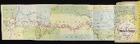
Union Pacific Railroad business hand book and emigrants’ guide from Omaha to Salt Lake and Corinne
Image Count:
1
Subject (Geographic):
West (U.S.) --Description and travel and West (U.S.) --Guidebooks
Subject (Name):
Union Pacific Railroad Company
Subject (Topic):
Railroad travel --West (U.S.) and Railroads--Maps
Collection Created:
Council Bluffs, Iowa : Bluff City Book and Job Printing House, 1871
Found in:
Beinecke Rare Book and Manuscript Library > Map of the land grant & connections of the Union Pacific Railroad
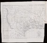
Call Number:
Zc52 833hob
Collection Title:
Texas
Image Count:
1
Resource Type:
Maps, Atlases & Globes
Subject (Geographic):
Mexican-American Border Region, Mexico., and Texas.
Collection Created:
Lexington, Ky., J. Clarke & Co., 1836
Found in:
Beinecke Rare Book and Manuscript Library > Map of the state of Coahuila and Texas
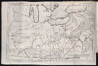
Call Number:
2003 310
Collection Title:
The journal of Major George Washington, : sent by the Hon. Robert Dinwiddie, Esq; His Majesty’s
Image Count:
1
Resource Type:
Books, Journals & Pamphlets
Description:
Verso blank.
Subject (Name):
Dinwiddie, Robert, 1693-1770 and St. Piere, Legardeur de
Subject (Topic):
Washington's Expedition to the Ohio, 1st, 1753-1754
Collection Created:
Williamsburgh printed ; London : Reprinted for T. Jefferys, 1754
Found in:
Beinecke Rare Book and Manuscript Library > Map of the western parts of the colony of Virginia, as far as the Mississipi [sic]
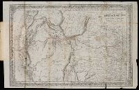
Creator:
Published / Created:
1852
Call Number:
Zc10 852ho
Collection Title:
Horn's overland guide, from the U.S. Indian sub-agency, Council Bluffs, on the Missouri River, to
Image Count:
1
Resource Type:
Maps, Atlases & Globes
Publisher:
J.H. Colton
Collection Created:
New York, J.H. Colton, 1852
Found in:
Beinecke Rare Book and Manuscript Library > Map to illustrate Horn's overland guide to California and Oregon
Creator:
Published / Created:
[1840]
Call Number:
1973 Folio 105
Collection Title:
Atlas fisico y politico de la Republica de Venezuela ... por ... Agustin Codazzi ...
Image Count:
1
Resource Type:
Maps, Atlases & Globes
Description:
Double page width, tab mounted. and Lith. de Thierry Fres. Cite Bergere 1 a Paris, printers.
Subject (Geographic):
Orinoco River Valley (Venezuela and Colombia), Venezuela --Description and travel, and Venezuela --Maps
Subject (Topic):
Physical geography --Venezuela
Collection Created:
Caracas,
Found in:
Beinecke Rare Book and Manuscript Library > Mapa de las costas de Tierra-Firme desde el Orinoco hasta Yucatan: de las islas Antillas y la mayor parte de las Lucayas, con las derrotas que siguio Dn. Cristobal Colon en sus descubrimientos por estos mares y las derrotas de otros navegantes que reconoc
Branch:v1.61.8 ,Deployed:2024-06-20T11:14:48-04:00