Skip to search
Skip to main content
Skip to first result
Search
You Searched For
Resource Type
Maps, Atlases & Globes
Language
German
New Search
Search Results
Creator:
Published / Created:
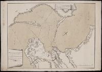
Au mois de Dec. 1774.
Call Number:
BrSides Folio 2019 58
Image Count:
1
Resource Type:
Maps, Atlases & Globes
Alternative Title:
Karte von der Meerenge zwischen dem Schwarzen und Assowschen Meere
Description:
Includes key of fortifications, camps, and water sources. and Relief shown by hachures. Depths shown by soundings.
Subject (Geographic):
Azov, Sea of (Ukraine and Russia)--Maps--Early works to 1800. and Kerch Peninsula (Ukraine)--Maps--Early works to 1800.
Found in:
Beinecke Rare Book and Manuscript Library > Karte von der Merenge zwischen dem Schwarzen und Assowschen Meere, wie auch von dem Stücke der Krim so Russland gehoeret. Anno 1774 / L. A. Colo. Mellin, Lieutenant de L'Etat Major de l'armee, fec.
Published / Created:
[1915?]
Call Number:
53 1915B
Container / Volume:
BRBL_00285
Image Count:
1
Resource Type:
Maps, Atlases & Globes
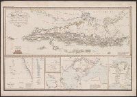
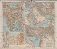
Description:
Balkanhalbinsel, 1:2,750,000 -- Westasien -- Die Anmarschlinien von Syrien nach Ägypten, 1:1,400,000 -- Türkisches Reich, 1:3,500,000. and Insets: Konstantinopel & Vororte, 1:100,000 -- Das Schwarze Meer 1:8,250,000 -- Ägypten bis zum ersten katarakt, 1:5,000,000 -- Unter-Ägypten, 1:2,500,000 -- Der Suês-Kanal, 1:500,000 -- Die Bai von Suês, 1:150,000 -- Suês 1:25,000 -- Unter-Mesopotamien.
Publisher:
Verlag der Geogr. Anstalt von Wagner & Debes,
Subject (Geographic):
Balkan Peninsula--Maps and Middle East--Maps
Found in:
Beinecke Rare Book and Manuscript Library > Karte zum Krieg im Orient.
Branch:v1.64.3 ,Deployed:2024-09-25T10:52:58-04:00