Special publication (Nevada Bureau of Mines and Geology) ; 28. and Special publication ; 28
Description:
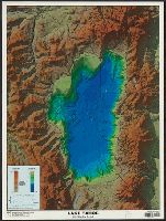
Includes elevation and depth graphs., Relief shown by shading, gradient tints, and spot heights. Depths shown by shading and gradient tints., and Shows roads, state boundary, Tahoe rim trail, and other geographic entities.
Publisher:
Nevada Bureau of Mines and Geology,
Subject (Geographic):
Tahoe, Lake (Calif. and Nev.)--Maps and Tahoe, Lake, Region (Calif. and Nev.)--Maps
Subject (Name):
Nevada Bureau of Mines and Geology and Pizarro, Kris Ann
Includes text, col. ill., chronology in the form of a time-line, and population graph., Panel title., Relief shown by shading on landforms map., and Satellite image 1999 -- Landforms 1000 A.D. : [map] -- Aerial photograph 1998 : [col. photo] -- Bird's-eye view 1867 : [facsimile].
Publisher:
Map Link Inc. [distributor], and White Star Press ;
Subject (Geographic):
Minneapolis (Minn.)--Aerial views, Minneapolis (Minn.)--Aerial views--Facsimiles, Minneapolis (Minn.)--Remote-sensing images, Minneapolis Metropolitan Area (Minn.)--Remote-sensing images, and Minneapolis Region (Min