Skip to search
Skip to main content
Skip to first result
Search
You Searched For
Extent of Digitization
Unspecified
Genre
Illustrations
Genre
Maps
New Search
Search Results
Published / Created:
1534
Call Number:
Taylor 74
Collection Title:
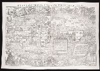
Epitome trium terrae partium Asiae, Africae et Europae compendiariam locorum descriptionem
Image Count:
1
Description:
Bound in before p. 1
Subject (Geographic):
World--maps
Subject (Topic):
Geography--Early works to 1800
Collection Created:
Tiguri : Apud Christophorum Frosch., mense Septemb. anno MDXXXIIII [1534]
Found in:
Beinecke Rare Book and Manuscript Library > Typus cosmographicus universalis
Published / Created:
1534
Call Number:
1976 +271
Collection Title:
Epitome trium terrae partium Asiae, Africae et Europae compendiariam locorum descriptionem
Image Count:
1
Description:
Bound in before p. 1
Subject (Geographic):
World--maps
Subject (Topic):
Geography--Early works to 1800
Collection Created:
Tiguri : Apud Christophorum Frosch., mense Septemb. anno MDXXXIIII [1534]
Found in:
Beinecke Rare Book and Manuscript Library > Typus cosmographicus universalis
Creator:
Published / Created:
[1532]
Call Number:
1986 +106
Collection Title:
Nouus orbis regionum ac insularum ueteribus incognitarum, / una` cum tabula cosmographica
Image Count:
1
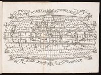
Abstract:
Map of the world, including the Americas.
Alternative Title:
Typus cosmographicus universalis
Description:
Bound in (tipped-in) before p. 1
Subject (Geographic):
America--Discovery and exploration., America--Early accounts to 1600, and World maps.
Collection Created:
Basileae : Apud Io. Heruagium, mense Martio, anno M.D.XXXII. [1532]
Found in:
Beinecke Rare Book and Manuscript Library > Typvs cosmographicvs vniversalis
Call Number:
Ck44 23
Collection Title:
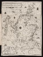
Kort beskrifning om provincien Nya Swerige uti America : som nu foertjden af the Engelske kallas
Image Count:
1
Description:
Between p. 52 & p. 53., Engraved by Holm, Thomas Campanius, ca. 1670-1702., and Teaching resource: Professor John Mack Faragher, History 141: The American West.
Subject (Geographic):
New England --Maps --Early works to 1800, United States --Maps --Early works to 1800, and Virginia --Maps --Early works to 1800
Collection Created:
Stockholm : Tryckt uti Kongl. boktr. hos S. Wankijfs ankia, med egen bekostnad, af J. H. Werner, 1702
Found in:
Beinecke Rare Book and Manuscript Library > Virginiae N. Angliae N. Hollandiae nec non Nova Sueviae delineatio
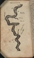
Call Number:
Zc20 802crc
Collection Title:
The navigator; or, The traders' useful guide in navigating the Monongahela, Allegheny, Ohio, and
Image Count:
1
Description:
P. 55.
Subject (Geographic):
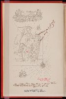
Chickasaw Bluffs (Tenn.), Mississippi River --Description and travel, Mississippi River --Maps, Mississippi River --Navigation, and Tennessee
Collection Created:
Pittsburgh, From the Press of Zadok Cramer, 1806
Found in:
Beinecke Rare Book and Manuscript Library > [A portion of the Mississippi River, including Chickasaw Bluffs]
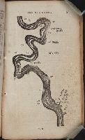
Call Number:
Zc20 802crc
Collection Title:
The navigator; or, The traders' useful guide in navigating the Monongahela, Allegheny, Ohio, and
Image Count:
1
Description:
P. 72.
Subject (Geographic):
Mississippi, Mississippi River --Description and travel, Mississippi River --Maps, Mississippi River --Navigation, and Natchez (Miss.)
Collection Created:
Pittsburgh, From the Press of Zadok Cramer, 1806
Found in:
Beinecke Rare Book and Manuscript Library > [A portion of the Mississippi River, including Natchez]
Branch:v1.61.8 ,Deployed:2024-06-20T11:15:15-04:00