- Creator:
- Geological Survey (U.S.)
- Published / Created:
- [1900].
- Call Number:
- 847gc El54 1899
- Container / Volume:
- BRBL_00628
- Image Count:
- 1
- Resource Type:
- Maps, Atlases & Globes
- Alternative Title:
- Ellensburg quadrangle, Washington :
- Description:
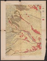
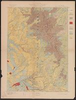
- "Julius Bien & Co. Lith. N.Y.", "Surveyed in 1899.", Plate CXXXII from the "Twenty-first annual report" of the U.S. Geological Survey, Part 5, Forest reserves (1900)., Relief shown by contours and spot heights., and Shows five classes of land cover.
- Publisher:
- The Survey,
- Subject (Geographic):
- Yakima County (Wash.)--Maps
- Subject (Name):
- Geological Survey (U.S.). Annual report, Murlin, A. E, and Plummer, Fred G. (Fred Gordon), 1864-1913
- Subject (Topic):
- Forests and forestry--Washington (State)--Kittitas County--Maps, Forests and forestry--Washington (State)--Yakima County--Maps, Kittitas County (Wash.)--Maps, and Land capability for agriculture--Washington (State)--Kittitas C
- Found in:
- Beinecke Rare Book and Manuscript Library > Washington, Ellensburg quadrangle : land classification and density of standing timber / U.S. Geological Survey ; R.U. Goode, geographer in charge ; triangulation by S.S. Gannett and A.H. Sylvester ; topography by A.E. Murlin ; Henry Gannett, geographer i
You Searched For
« Previous
| 51 - 60 of 60 |
Next »
Search Results
- Creator:
- Geological Survey (U.S.)
- Published / Created:
- [1900].
- Call Number:
- 847gc M865 1897
- Container / Volume:
- BRBL_00628
- Image Count:
- 1
- Resource Type:
- Maps, Atlases & Globes
- Alternative Title:
- Mount Stuart quadrangle, Washington :
- Description:
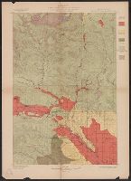
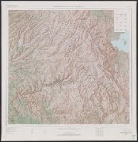
- "Julius Bien & Co. Lith. N.Y.", "Surveyed in 1896-97.", Plate CXXXI from the "Twenty-first annual report" of the U.S. Geological Survey, Part 5, Forests reserves (1900)., Relief shown by contours and spot heights., and Shows five classes of land cover.
- Publisher:
- The Survey,
- Subject (Geographic):
- Chelan County (Wash.)--Maps, Kittitas County (Wash.)--Maps, and Wenatchee National Forest (Wash.)--Maps
- Subject (Name):
- Geological Survey (U.S.). Annual report and Plummer, Fred G. (Fred Gordon), 1864-1913
- Subject (Topic):
- Forests and forestry--Washington (State)--Chelan County--Maps, Forests and forestry--Washington (State)--Kittitas County--Maps, and Land capability for agriculture--Washington (State)--Kittitas County--Maps
- Found in:
- Beinecke Rare Book and Manuscript Library > Washington, Mount Stuart quadrangle : land classification and density of standing timber / U.S. Geological Survey ; R.U. Goode, geographer in charge ; triangulation by S.S. Gannett ; topography by G.E. Hyde ; Henry Gannett, geographer in charge ; land cla
- Creator:
- Geological Survey (U.S.)
- Published / Created:
- [1901]
- Call Number:
- 847gc Sp65 1898
- Container / Volume:
- BRBL_00628
- Image Count:
- 1
- Resource Type:
- Maps, Atlases & Globes
- Alternative Title:
- Spokane quadrangle, Washington-Idaho :
- Description:
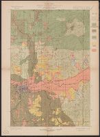
- "Engraved April 1901 by Julius Bien & Co., "Surveyed in 1898.", Plate CXXXIV from the "Twenty-first annual report" of the U.S. Geological Survey, Part 5, Forest reserves (1900)., Relief shown by contours and spot heights., and Shows six classes of land cover.
- Publisher:
- The Survey,
- Subject (Geographic):
- Spokane County (Wash.)--Maps
- Subject (Name):
- Geological Survey (U.S.). Annual report, Manning, Van H, and Plummer, Fred G. (Fred Gordon), 1864-1913
- Subject (Topic):
- Forests and forestry--Washington (State)--Spokane County--Maps and Land capability for agriculture--Washington (State)--Spokane County--Maps
- Found in:
- Beinecke Rare Book and Manuscript Library > Washington-Idaho, Spokane quadrangle : land classification and density of standing timber / U.S. Geological Survey ; R.U. Goode, geographer in charge ; triangulation by S.S. Gannett ; topography by Van H. Manning ; Henry Gannett, geographer in charge ; la
- Creator:
- Geological Survey (U.S.)
- Published / Created:
- [1900].
- Call Number:
- 833gc B19 1898
- Container / Volume:
- BRBL_00586
- Image Count:
- 1
- Resource Type:
- Maps, Atlases & Globes
- Alternative Title:
- Bald Mountain quadrangle, Wyoming :
- Description:
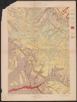
- "Julius Bien & Co. Lith. N.Y.", "Surveyed in 1898.", Plate CXXXIX from the "Twenty-first annual report" of the U.S. Geological Survey, Part 5, Forest reserves (1900)., Relief shown by contours and spot heights., and Shows six classes of land cover.
- Publisher:
- The Survey,
- Subject (Geographic):
- Big Horn County (Wyo.)--Maps, Bighorn National Forest (Wyo.)--Maps, and Sheridan County (Wyo.)--Maps
- Subject (Name):
- Geological Survey (U.S.). Annual report and Tweedy, Frank, 1854-1937
- Subject (Topic):
- Forests and forestry--Wyoming--Big Horn County--Maps, Forests and forestry--Wyoming--Sheridan County--Maps, Land capability for agriculture--Wyoming--Big Horn County--Maps, and Land capability for agriculture--Wyoming--Sherida
- Found in:
- Beinecke Rare Book and Manuscript Library > Wyoming, Bald Mountain quadrangle : land classification and density of standing timber / U.S. Geological Survey ; E.M. Douglas, geographer in charge ; triangulation by W.S. Post ; topography by Frank Tweedy ; Henry Gannett, geographer in charge ; land cla
- Creator:
- Geological Survey (U.S.)
- Published / Created:
- [1900].
- Call Number:
- 833gc C625 1899
- Container / Volume:
- BRBL_00586
- Image Count:
- 1
- Resource Type:
- Maps, Atlases & Globes
- Alternative Title:
- Cloud Peak quadrangle, Wyoming :
- Description:
- "Julius Bien & Co. Lith. N.Y.", "Surveyed in 1897-99.", Plate CXL from the "Twenty-first annual report" of the U.S. Geological Survey, Part 5, Forest reserves (1900)., Relief shown by contours and spot heights., and Shows six classes of land cover.
- Publisher:
- The Survey,
- Subject (Geographic):
- Big Horn County (Wyo.)--Maps, Bighorn National Forest (Wyo.)--Maps, and Johnson County (Wyo.)--Maps
- Subject (Name):
- Geological Survey (U.S.). Annual report and Matthes, François, 1874-1948
- Subject (Topic):
- Forests and forestry--Wyoming--Big Horn County--Maps, Forests and forestry--Wyoming--Johnson County--Maps, Land capability for agriculture--Wyoming--Big Horn County--Maps, and Land capability for agriculture--Wyoming--Johnson
- Found in:
- Beinecke Rare Book and Manuscript Library > Wyoming, Cloud Peak quadrangle : land classification and density of standing timber / U.S. Geological Survey ; E.M. Douglas, geographer in charge ; triangulation by T.M. Bannon ; topography by H.S. Wallace and F.E. Matthes ; Henry Gannett, geographer in c
56.
- Creator:
- Geological Survey (U.S.)
- Published / Created:
- [1900].
- Call Number:
- 833gc D337 1899
- Container / Volume:
- BRBL_00586
- Image Count:
- 1
- Resource Type:
- Maps, Atlases & Globes
- Alternative Title:
- Dayton quadrangle, Wyoming :
- Description:
- "Julius Bien & Co. Lith. N.Y.", "Surveyed in 1899.", Plate CXXXVIII from the "Twenty-first annual report" of the U.S. Geological Survey, Part 5, Forest reserves (1900)., Relief shown by contours and spot heights., and Shows six classes of land cover.
- Publisher:
- The Survey,
- Subject (Geographic):
- Bighorn National Forest (Wyo.)--Maps and Sheridan County (Wyo.)--Maps
- Subject (Name):
- Geological Survey (U.S.). Annual report, Julius Bien & Co, and Tweedy, Frank, 1854-1937
- Subject (Topic):
- Forests and forestry--Wyoming--Sheridan County--Maps and Land capability for agriculture--Wyoming--Sheridan County--Maps
- Found in:
- Beinecke Rare Book and Manuscript Library > Wyoming, Dayton quadrangle : land classification and density of standing timber / U.S. Geological Survey ; E.M. Douglas, geographer in charge ; triangulation by W.S. Post ; topography by Frank Tweedy ; Henry Gannett, geographer in charge ; land classifica
- Creator:
- Geological Survey (U.S.)
- Published / Created:
- [1901]
- Call Number:
- 833gc N431 1899
- Container / Volume:
- BRBL_00586
- Image Count:
- 1
- Resource Type:
- Maps, Atlases & Globes
- Alternative Title:
- Newcastle quadrangle, Wyoming-South Dakota :
- Description:
- "Engraved Apr. 1901 by Julius Bien & Co.", "Surveyed, Plate CXLI from the "Twenty-first annual report" of the U.S. Geological Survey, Part 5, Forest reserves (1900)., Relief shown by contours and spot heights., and Shows four classes of land cover.
- Publisher:
- The Survey,
- Subject (Geographic):
- Black Hills National Forest (S.D. and Wyo.)--Maps and Weston County (Wyo.)--Maps
- Subject (Name):
- Geological Survey (U.S.). Annual report and Julius Bien & Co
- Subject (Topic):
- Forests and forestry--Wyoming--Weston County--Maps and Land capability for agriculture--Wyoming--Weston County--Maps
- Found in:
- Beinecke Rare Book and Manuscript Library > Wyoming-South Dakota, Newcastle quadrangle : land classification and density of standing timber / U.S. Geological Survey ; E.M. Douglas, geographer in charge ; triangulation by Frank Tweedy and R.H. Chapman ; topography by W.H. Herron ; Henry Gannett, geo
58.
- Creator:
- Geological Survey (U.S.)
- Published / Created:
- [188-?]
- Call Number:
- 833fcm Y38 1885
- Container / Volume:
- BRBL_00585
- Image Count:
- 1
- Resource Type:
- Maps, Atlases & Globes
- Alternative Title:
- Yellowstone National Park and northwestern Wyoming
- Description:
- "Surveyed in 1883-4-5." and Relief shown by contours and spot heights.
- Publisher:
- Geological Survey,
- Subject (Geographic):
- Yellowstone National Park--Maps, Topographic
- Subject (Name):
- Aplin, S. A, Chase, H. S, Gannett, Henry, 1846-1914, Julius Bien & Co, Renshawe, John H, and Tweedy, Frank, 1854-1937
- Found in:
- Beinecke Rare Book and Manuscript Library > Yellowstone National Park and north western Wyoming / U.S. Geological Survey ; Henry Gannett, Chief Geographer ; J.H. Renshawe, Geographer in Charge ; triangulation by H.S. Chase ; topography by J.H. Renshawe, Frank Tweedy, and S.A. Aplin, Jr.
59.
- Creator:
- Geological Survey (U.S.)
- Published / Created:
- [1958]
- Call Number:
- 844fcm Y83 1958
- Container / Volume:
- BRBL_00615
- Image Count:
- 1
- Resource Type:
- Maps, Atlases & Globes
- Alternative Title:
- Yosemite National Park and vicinity, Calif. :
- Description:
- "Compiled in 1963 from 1:62,500-scale maps dated 1947, 1953, 1956, and 1958.", "N3728--W11900/45X60.", Includes location map and USGS index map., and Relief shown by shading, contours, and spot heights.
- Publisher:
- The Survey,
- Subject (Geographic):
- Yosemite National Park (Calif.)--Maps
- Found in:
- Beinecke Rare Book and Manuscript Library > Yosemite National Park, and vicinity, California / mapped, edited, and published by the Geological Survey.
- Creator:
- Geological Survey (U.S.)
- Published / Created:
- 1917
- Call Number:
- 779 W27 1917A
- Container / Volume:
- BRBL_00505A
- Image Count:
- 2
- Resource Type:
- Maps, Atlases & Globes
- Description:
- "March 4, 1917." and "Reprint of the city portion of Washington, D.C. and vicinity map issued by the United States Geological Survey."
- Subject (Geographic):
- Washington (D.C.)--Maps
- Found in:
- Beinecke Rare Book and Manuscript Library > Your national capital.