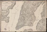
Includes "View of Boston," inset of Halifax Harbor, and insets, with i, Inscribed to "His Majesty's Province of Nova Scotia ... ", Relief shown pictorially., and Shows the Maritime Provinces, Newfoundland, and the St. Laurence River Valley between 1755 and 1757.
Publisher:
Printed and sold by R. Aitken,
Subject (Geographic):
Canada--Maps--Early works to 1800, Halifax (N.S.)--Maps--Early works to 1800, Maritime Provinces--Maps--Early works to 1800, Nova Scotia--Maps--Early works to 1800, and Québec (Québec)--Maps--Early works to 1800
Subject (Name):
Aitken, Robert, 1735-1802
Subject (Topic):
Harbors--Nova Scotia--Louisbourg--Maps--Early works to 1800
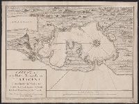
"Entered according to act of Congress in the year 1835 by T.W. Satterthwaite in the clerks office of the district court of the southern district of New York.", "Entered according to act of provincial parliament Quebec April 1835.", and Includes "View of Quebec
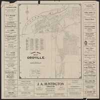
Butte County, California., Map of Oroville, California, and New 1928 map of Oroville, California
Description:
"Copyright by Geo. C. Thomas.", Includes index and advertisements., and Map of "Butte County, California" (scale [ca. 1:255,000], dated 4-23-28), location map, ill., and text of "Oroville, gateway to the Feather River country"on verso.
Publisher:
Thomas Bros., [1928]
Subject (Geographic):
Butte County (Calif.)--Maps and Oroville (Calif.)--Maps
Includes advertisements for Thomas County Bank and Ike W. Crumly, asbtractor and dealer in real estate. and Shows townships and sections and railroads.
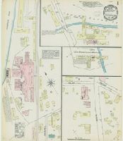
Sanborn fire insurance maps are a rich source of historic data on the urban built environment of North America during the 19th and early 20th centuries. The atlases were created for the purpose of underwriting fire insurance policies, which depended upon accurate and frequently-updated information about construction materials, municipal and transportation infrastructure, industrial and commercial landuse and more. The Yale University Library Map Department scanned its holdings of Sanborn fire insurance maps (consisting primarily of Connecticut towns) in order to make the maps more accessible.
Alternative Title:
May 1884, Thomaston, Conn.
Description:
"2 sheets.", Contains information on population, prevailing winds, water facilities and fire department., Partial cadastral map., and SMLMAPL 766 T36 1884: Sheets disbound. "Triplicate" stamp on both sheets. Library of Congress copyright stamp on title sheet.
Subject (Geographic):
Thomaston (Conn.)--Maps
Subject (Name):
Library of Congress Stamp
Subject (Topic):
Fire risk assessment--Connecticut--Thomaston--Maps and Real property--Connecticut--Thomaston--Maps
Sanborn fire insurance maps are a rich source of historic data on the urban built environment of North America during the 19th and early 20th centuries. The atlases were created for the purpose of underwriting fire insurance policies, which depended upon accurate and frequently-updated information about construction materials, municipal and transportation infrastructure, industrial and commercial landuse and more. The Yale University Library Map Department scanned its holdings of Sanborn fire insurance maps (consisting primarily of Connecticut towns) in order to make the maps more accessible.
Alternative Title:
Jan. 1890, Thomaston, Conn.
Description:
"3622. 3 sheets.", Contains information on population, prevailing winds, water facilities and fire department., Partial cadastral map., and SMLMAPL 766 T36 1890: Sheets disbound. "Triplicate" stamp on all sheets. Library of Congress copyright stamp on title sheet.
Subject (Geographic):
Thomaston (Conn.)--Maps
Subject (Name):
Library of Congress Stamp
Subject (Topic):
Fire risk assessment--Connecticut--Thomaston--Maps and Real property--Connecticut--Thomaston--Maps