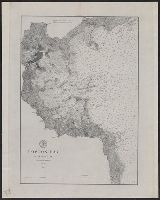
"2144"., "Corrections Sept. 1862.", and Chart of coast from Broken Bay to Sugarloaf Point with relief shown by hachures, bathymetric soundings and spot heights.
Publisher:
Published according to Act of Parliament at the Hydrographic Office of The Admiralty : and Sold by J.D. Potter Agent for the Admiralty charts 31 Poultry,
Evans, F. J. (Frederick J.) Great Britain. Hydrographic Dept J. & C. Walker (Firm) Potter, J. D. (John D.) Washington Capt
Published / Created:
Decr. 12th 1860.
Call Number:
26cea 1860
Container / Volume:
BRBL_00023
Image Count:
1
Resource Type:
Maps, Atlases & Globes
Alternative Title:
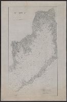
Coral Sea and Great Barrier Reefs shewing the inner and outer routes to Torres Strait
Description:
"2764"., Imperfect: Mutilated with loss of tex, Nautical chart of the Great Barrier Reef and the Coral Sea showing routes to the Torres Strait. Relief is shown by hachures and spot heights. Depth shown by bathymetric soundings., and On verso: XXVIII.
Publisher:
Published at the Admiralty ... under the superintendence of Captn. Washington R.N., F.R.S. Hydrographer ; Sold by J.D. Potter, agent for the Admiralty charts, 31 Poultry and 11 King Street, Tower Hill,
Subject (Geographic):
Coral Sea--Maps and Great Barrier Reef (Qld.)--Maps
"2764"., Compiled chiefly from the Surveys by Captains Flinders, Blackwood, Stanley, Yule & Denham 1802-60, with additions from various surveys to 1885., Includes large corrections to Mar. 1896, and small corrections to "IX.11.", Prime meridian: Greenwich., and R
Subject (Geographic):
Coral Sea--Maps and Great Barrier Reef (Qld.)--Maps
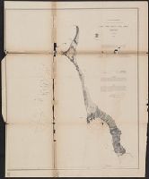
Peirce, Benjamin, 1809-1880 United States Coast Survey
Published / Created:
1869
Call Number:
846cea Or4 1869
Container / Volume:
BRBL_00623
Image Count:
1
Resource Type:
Maps, Atlases & Globes
Description:
In upper left margin: No. 16., Includes notes., Relief shown by hachures. Depths shown by soundings., and Removed from: United States Coast Survey, Annual report of the superintendent of the Coast Survey (1869).
Publisher:
U.S. Coast Survey,
Subject (Geographic):
Blanco, Cape (Or.)--Maps and Port Orford (Or.)--Maps
Subject (Name):
United States Coast Survey. Annual report of the superintendent of the Coast Survey. 1869
"No. 66" in upper right corner., Cross Collection no. 256., Depths shown by soundings., Inset: Carte des embouchures du fleuve St. Louis., Prime meridian: Paris., and Relief shown pictorially.
Publisher:
s.n.],
Subject (Geographic):
Gulf Coast (Fla.)--Maps--Early works to 1800
Subject (Name):
France. Dépôt des cartes et plans de la marine
Subject (Topic):
Coasts--Gulf States--Maps--Early works to 1800 and Coasts--Louisiana--Maps--Early works to 1800