Skip to search
Skip to main content
Skip to first result
Search
You Searched For
Format
cartographic
Resource Type
Maps, Atlases & Globes
New Search
Search Results
Creator:
Published / Created:
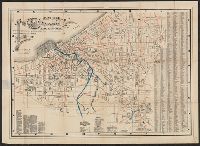
Nov. 29, 1911
Call Number:
833 C429 1911
Container / Volume:
BRBL_00584
Image Count:
2
Resource Type:
Maps, Atlases & Globes
Alternative Title:
Map of Cheyenne
Description:
Coordinates not present on map and are approximated. and Original wrappers.
Publisher:
Pioneer Abstract Co.,
Subject (Geographic):
Cheyenne (Wyo.)--Maps.
Subject (Name):
Chapman, Mark A., Cheyenne Printing Co., and Porak, H. G.
Found in:
Beinecke Rare Book and Manuscript Library > Map of city of Cheyenne and adjacent subdivisions / compiled by the Pioneer Abstract Co., Cheyenne, Wyo. from government, county, and other official records ; H.G. Porak, del. ; compliments of Mark A. Chapman, fire, insurance, and real estate.
Published / Created:
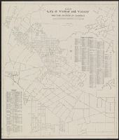
1881
Call Number:
804 C599 1881
Container / Volume:
BRBL_00544
Image Count:
1
Resource Type:
Maps, Atlases & Globes
Description:
Lists of various landmarks.
Publisher:
W.J. Morgan & Co., Lith.,
Subject (Geographic):
Cleveland (Ohio)--Maps
Found in:
Beinecke Rare Book and Manuscript Library > Map of city of Cleveland and suburbs showing location and distance from public square of all streets / J.S. Morse.
Creator:
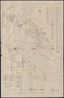
Published / Created:
1909
Call Number:
831 H36 1909
Container / Volume:
BRBL_00580
Image Count:
6
Resource Type:
Maps, Atlases & Globes
Alternative Title:
Guide to Helena, Montana and Guide to the capital city of Montana, Helena.
Description:
Guidebook gives description, Guidebook title page: A guide to the capital city of Montana, Helena., On verso: Index to subdivisions and streets., and Shows streets, railroad and streetcar lines, and additions to the city. Includes photograph and advertisements.
Publisher:
Clason Map Company,
Subject (Geographic):
Helena (Mont.)--Maps
Subject (Name):
Clason, George S. (George Samuel), 1874-1957
Subject (Topic):
Streets--Montana--Helena--Maps
Found in:
Beinecke Rare Book and Manuscript Library > Map of city of Helena, Montana / Copyrighted 1909 by Geo. S. Clason.
Creator:
Published / Created:
1945
Call Number:
844 W61 1945
Container / Volume:
BRBL_00611
Image Count:
2
Resource Type:
Maps, Atlases & Globes
Alternative Title:
Map of Whittier California and vicinity and Road and resort map, south Pacific Coast Region.
Description:
Includes text, distance list, and "Road and resort map, south Pacific Coast Region." and Indexed.
Publisher:
Whittier Chamber of Commerce,
Subject (Geographic):
Whittier (Calif.)--Maps
Subject (Name):
Whittier Area Chamber of Commerce
Subject (Topic):
Roads--California--Maps and Streets--California--Whittier--Maps
Found in:
Beinecke Rare Book and Manuscript Library > Map of city of Whittier and vicinity / issued by Whittier Chamber of Commerce ; prepared by the Engineering Department, city of Whittier.
Published / Created:
c1932.
Call Number:
844 W61 1931
Container / Volume:
BRBL_00611
Image Count:
2
Resource Type:
Maps, Atlases & Globes
Alternative Title:
Map of Whittier California and vicinity and Road and resort map, south Pacific Coast Region.
Description:
Copyright date on map: 1931., Copyright: J.M. Kemmerer., Includes indexes and distance list., and Includes text, distance list, and "Road and resort map, south Pacific Coast Region" (copyright, Touring League of America).
Publisher:
Whittier Chamber of Commerce,
Subject (Geographic):
Whittier (Calif.)--Maps
Subject (Name):
Kemmerer, J. M and Whittier Area Chamber of Commerce
Subject (Topic):
Roads--California--Maps and Streets--California--Whittier--Maps
Found in:
Beinecke Rare Book and Manuscript Library > Map of city of Whittier and vicinity / issued by Whittier Chamber of Commerce.
Published / Created:
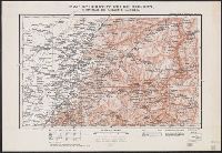
1905
Call Number:
565 T442 1905
Container / Volume:
BRBL_00299
Image Count:
1
Resource Type:
Maps, Atlases & Globes
Alternative Title:
TSGS ; 2016 and TSGS ; 2016.
Description:
"Reproduced from Russian Staff map 1904.", "War Office, March, 1905. Revised May, 1905.", and Includes index map.
Publisher:
War Office,
Subject (Geographic):
Manchuria (China)--Maps
Subject (Name):
Great Britain. War Office. General Staff. Geographical Section
Found in:
Beinecke Rare Book and Manuscript Library > Map of country north of T'ieh-ling : to illustrate the campaign in Manchuria.
Published / Created:
1905
Call Number:
565 M89 1905
Container / Volume:
BRBL_00299
Image Count:
1
Resource Type:
Maps, Atlases & Globes
Alternative Title:
TSGS ; 1982 and TSGS ; 1982.
Description:
"Reproduced from Russian Staff map, 1904.", "War Office, January, 1905. Corrected May, 1905.", and Includes index map.
Publisher:
War Office,
Subject (Geographic):
Manchuria (China)--Maps and Shenyang (Liaoning, China)--Maps
Subject (Name):
Great Britain. War Office. General Staff. Geographical Section
Found in:
Beinecke Rare Book and Manuscript Library > Map of country round Mukden : to illustrate the campaign in Manchuria.
Published / Created:
1905
Call Number:
565 H212 1905
Container / Volume:
BRBL_00299
Image Count:
1
Resource Type:
Maps, Atlases & Globes
Alternative Title:
TSGS ; 2019 and TSGS ; 2019.
Description:
"Reproduced from Russian Staff map 1904."
Publisher:
War Office,
Subject (Geographic):
Harbin Region (China)--Maps and Manchuria (China)--Maps
Subject (Name):
Great Britain. War Office. General Staff. Geographical Section
Found in:
Beinecke Rare Book and Manuscript Library > Map of country south of Harbin : to illustrate the campaign in Manchuria.
Published / Created:
1905
Call Number:
565 N622 1905
Container / Volume:
BRBL_00299
Image Count:
1
Resource Type:
Maps, Atlases & Globes
Alternative Title:
TSGS ; 2044 and TSGS ; 2044.
Description:
"Reproduced from Russian Staff map 1904.", "War Office, May, 1905.", and Includes index map.
Publisher:
War Office,
Subject (Geographic):
Manchuria (China)--Maps
Subject (Name):
Great Britain. War Office. General Staff. Geographical Section
Found in:
Beinecke Rare Book and Manuscript Library > Map of country west of Ninguta : to illustrate the campaign in Manchuria.
Creator:
Published / Created:
1974]
Call Number:
844 L89 1974
Container / Volume:
BRBL_00606
Image Count:
1
Resource Type:
Maps, Atlases & Globes
Description:
"Neg 160 R.", Blue line print., and Includes inset of Santa Catalina Island and San Clemente Island.
Publisher:
Dept. of County Engineer,
Subject (Geographic):
Los Angeles County (Calif.)--Maps
Subject (Name):
Brandt, Harvey T
Found in:
Beinecke Rare Book and Manuscript Library > Map of county of Los Angeles / Harvey T. Brandt, County Engineer.
Branch:v1.61.6 ,Deployed:2024-06-12T09:55:19-04:00