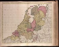
Appears in Valk and Schenk's Atlantis sylloge compendiosa, ca. 1702., Backed with paper. Ms. no. "40" in upper-right corner. Sheet measures 53.6 x 63.0 cm. No. 39 of 87 maps bound together., Bar scales given in "horae itinerissive milliaria Gallica" and "milliaria Germanica"., Prime meridian: Ferro., and Watermark.
Publisher:
Gerard Valk,
Subject (Geographic):
Netherlands--Maps--Early works to 1800.
Subject (Name):
Schenk, Peter, 1660-1718 or 1719. Atlantis sylloge compendiosa., Valck, G. (Gerard), 1651 or 1652-1726. Atlantis sylloge compendiosa., and Valck, Leonard, 1675-1746.
Appeared in Valk and Schenk's Atlantis sylloge compendiosa, ca. 1702., Backed with paper. Ms. no. "82" in upper left corner. Sheet measures 62.5 x 53.7 cm. No. 76 of 87 maps bound together., Bar scales given in "milliaria Hungarica" and "milliaria Germanica.", Prime meridian: Ferro., and Relief shown pictorially.
Publisher:
Gerard Valk,
Subject (Geographic):
Bulgaria--Maps--Early works to 1800., Romania--Maps--Early works to 1800., and Turkey--Maps--Early works to 1800.
Subject (Name):
Schenk, Peter, 1660-1718 or 1719. Atlantis sylloge compendiosa. and Valck, G. (Gerard), 1651 or 1652-1726. Atlantis sylloge compendiosa.
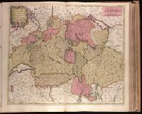
Backed with paper. Ms. no. "34" in upper left-hand corner. Sheet measures 53.6 x 62.9 cm. No. 33 of 87 maps bound together., Bar scales given in "milliaria Germanica" and "milliaria Gallica"., and Prime meridian: Ferro.
Appears in Valk and Schenk's Atlantis sylloge compendiosa, ca. 1702., Bar scales given in "milliaria Germanica communia" and "milliaria Gallica communia"., BEIN 1973 Folio 18: Imperfect: slight stains on verso and recto, with no loss of text. Backed with paper. Ms. no. in upper right corner: 22. Sheet measures 53.7 x 62.8 cm. No. 22 of 87 maps bound together., Prime meridian: Ferro., Relief shown pictorially., and Watermark.
Publisher:
Gerard Valck,
Subject (Geographic):
Germany, Northern--Maps--Early works to 1800.
Subject (Name):
Schenk, Peter, 1660-1718 or 1719. Atlantis sylloge compendiosa., Valck, G. (Gerard), 1651 or 1652-1726. Atlantis sylloge compendiosa., and Valck, Leonard, 1675-1746.
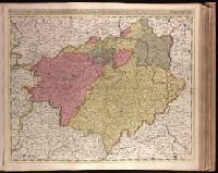
Appears in Valk and Schenk's Atlantis sylloge compendiosa, ca. 1702., Backed with paper. Ms. no. in upper right corner: 24. Sheet measures 53.7 x 62.7 cm. No. 24 of 87 maps bound together., Bar scales given in "milliaria Germanica communia" and "milliaria Gallica communia"., Prime meridian: Ferro., Relief shown pictorially., and Watermark.
Publisher:
Gerard Valck,
Subject (Geographic):
Brandenburg (Germany)--Maps--Early works to 1800., Saxony (Germany)--Maps--Early works to 1800., Saxony-Anhalt (Germany)--Maps--Early works to 1800., and Thuringia (Germany)--Maps--Early works to 1800.
Subject (Name):
Schenk, Peter, 1660-1718 or 1719. Atlantis sylloge compendiosa., Valck, G. (Gerard), 1651 or 1652-1726. Atlantis sylloge compendiosa., and Valck, Leonard, 1675-1746.
Appeared in Valk and Schenk's Atlantis sylloge compendiosa, ca. 1702., Backed with paper. Ms. no. "29" in upper left-hand corner. Sheet measures 53.5 x 62.5 cm. No. 29 of 87 maps bound together., Includes five bar scales., Prime meridian: Ferro., Relief shown pictorially., and Watermark.
Publisher:
Gerard Valk,
Subject (Geographic):
Switzerland--Maps--Early works to 1800.
Subject (Name):
Schenk, Peter, 1660-1718 or 1719. Atlantis sylloge compendiosa. and Valck, G. (Gerard), 1651 or 1652-1726. Atlantis sylloge compendiosa.
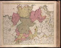
Appears in Valk and Schenk's Atlantis sylloge compendiosa, ca. 1702., Bar scales given in "milliaria Germanica communia" and "milliaria Gallica communia"., Imperfect: slight stains on verso and recto, with no loss of text. Backed with paper. Ms. no. in upper right corner: 23. Sheet measures 53.7 x 62.8 cm. No. 23 of 87 maps bound together., Prime meridian: Ferro., and Relief shown pictorially.
Publisher:
Gerard Valck,
Subject (Geographic):
Pomerania (Poland and Germany)--Maps--Early works to 1800.
Subject (Name):
Schenk, Peter, 1660-1718 or 1719. Atlantis sylloge compendiosa., Valck, G. (Gerard), 1651 or 1652-1726. Atlantis sylloge compendiosa., and Valck, Leonard, 1675-1746.
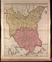
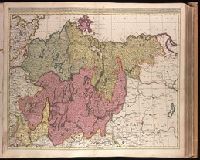
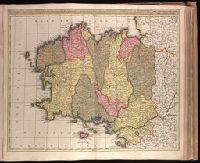
Appeared in Valk and Schenk's Atlantis sylloge compendiosa, ca. 1702., Backed with paper. Ms. no. "60" in upper right-hand corner. Sheet measures 53.6 x 62.8 cm. No. 55 of 87 maps bound together., Bar scales given in "milliaria Gallica" and "milliaria Germanica.", Prime meridian: Ferro., Relief shown pictorially., and Variation of Koeman, C. Atlantes Neerlandici, III, p. 138 (map 23); with addition of "Leo. Valk."
Publisher:
Gerard and Valk,
Subject (Geographic):
Brittany (France)--Maps--Early works to 1800.
Subject (Name):
Schenk, Peter, 1660-1718 or 1719. Atlantis sylloge compendiosa., Valck, G. (Gerard), 1651 or 1652-1726. Atlantis sylloge compendiosa., and Valck, Leonard, 1675-1746.
Appeared in Valk and Schenk's Atlantis sylloge compendiosa, ca. 1702., Backed with paper. Ms. no. "83" in upper right-hand corner. Sheet measures 53.5 x 62.0 cm. No. 77 of 87 maps bound together., Bar scales given in "milliaria Hungarica" and "milliaria Germanica.", Prime meridian: Ferro., and Relief shown pictorially.
Publisher:
Gerard and Leonard Valk,
Subject (Geographic):
Romania--Maps--Early works to 1800.
Subject (Name):
Schenk, Peter, 1660-1718 or 1719. Atlantis sylloge compendiosa. and Valck, G. (Gerard), 1651 or 1652-1726. Atlantis sylloge compendiosa.
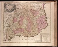
Appears in Valk and Schenk's Atlantis sylloge compendiosa, ca. 1702., Backed with paper. Ms. no. "64" in upper right corner. Sheet measures 53.7 x 62.1 cm. No. 59 of 87 maps bound together., Includes 5 bar scales., Prime meridian: Ferro., Relief shown pictorially., and Watermark.
Publisher:
Gerard Valck,
Subject (Geographic):
Catalonia (Spain)--Maps--Early works to 1800.
Subject (Name):
Schenk, Peter, 1660-1718 or 1719. Atlantis sylloge compendiosa., Valck, G. (Gerard), 1651 or 1652-1726. Atlantis sylloge compendiosa., and Valck, Leonard, 1675-1746.