Skip to search
Skip to main content
Skip to first result
Search
You Searched For
Genre
Maps
Language
Italian
New Search
Search Results
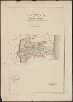
Published / Created:
1866
Call Number:
40 M313 1859A
Container / Volume:
BRBL_00210
Image Count:
1
Resource Type:
Maps, Atlases & Globes
Publisher:
Cesare Crivelli,
Subject (Geographic):
Mantua (Italy : Province)--Maps
Found in:
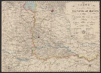
Beinecke Rare Book and Manuscript Library > Carta topografica militare della Provincia di Mantova : il perimetro dello stato suo attuale l'ultima rettifica del giorno 18 Mag. 1866.
Published / Created:
1859
Call Number:
40 M313 1859
Container / Volume:
BRBL_00210
Image Count:
1
Resource Type:
Maps, Atlases & Globes
Publisher:
Cesare Crivelli,
Subject (Geographic):
Mantua (Italy : Province)--Maps
Found in:
Beinecke Rare Book and Manuscript Library > Carta topografica militare della Provincia di Mantova : il perimetro dello stato suo attuale l'ultima rettifica del giorno 28 Mag. 1859.
Creator:
Published / Created:
[1919]
Call Number:
30f 1919
Container / Volume:
BRBL_00037B
Image Count:
1
Resource Type:
Maps, Atlases & Globes
Alternative Title:
Carta-base della futura Europa politica, cenno esplicativo.
Description:
Accompanied by: Carta-base della futura Europa politica, cenno esplicativo. 15 p. ; 24 cm., Relief shown by shading and spot heights., and Shows existing and projected borders in Europe and adjacent parts of Middle East.
Publisher:
Istituto geografico De Agostini,
Subject (Geographic):
Europe--Boundaries--Maps
Subject (Name):
Istituto geografico De Agostini
Subject (Topic):
World War, 1914-1918--Territorial questions--Maps
Found in:
Beinecke Rare Book and Manuscript Library > Carta-base della futura Europa politica [cartographic material] / G. Bertoldo, red.
Published / Created:
[1800]
Call Number:
408 1800A
Container / Volume:
BRBL_00238
Image Count:
1
Resource Type:
Maps, Atlases & Globes
Publisher:
Lit. Bertotti,
Subject (Geographic):
Kingdom of the Two Sicilies--Maps, Naples (Kingdom)--Maps, and Sicily (Italy)--Maps
Found in:
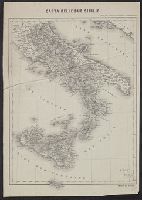
Beinecke Rare Book and Manuscript Library > Carte delle Due Sicilie.
Call Number:
40 1860B
Container / Volume:
BRBL_00201
Image Count:
1
Resource Type:
Maps, Atlases & Globes
Alternative Title:
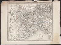
Carta postale dei diversi passaggi delle Alpi e del Piemonte
Description:
Coordinates not present on map and are approximated. and Relief shown by hachures.
Subject (Geographic):
Alps--Maps
Subject (Name):
Artaria, Ferdinando, publisher
Subject (Topic):
Post roads--Alps--Maps
Found in:
Beinecke Rare Book and Manuscript Library > Carte routiere des differents passages des Alpes et du Piemont = Carta postale dei diversi passaggi delle Alpi e del Piemonte.
Call Number:
401 1830
Container / Volume:
BRBL_00233
Image Count:
2
Resource Type:
Maps, Atlases & Globes
Alternative Title:
Carta postale dei diversi passaggi delle Alpi e del Piemonte
Description:
Hand colored. and Relief shown by hachures.
Subject (Geographic):
Alps--Maps, Mountain passes--Alps--Maps, Piedmont (Italy)--Maps, Post roads--Alps--Maps, Post roads--Italy--Piedmont--Maps, Post roads--Switzerland--Maps, Road, and Roads--Alps--Maps
Found in:
Beinecke Rare Book and Manuscript Library > Carte routière des différents passages des Alpes et du Piémont = Carta postale dei diversi passaggi delle Alpi e del Piemonte.
Creator:
Published / Created:
1596
Call Number:
Taylor 224
Collection Title:
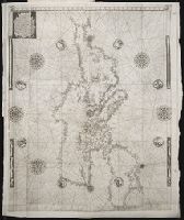
Navtica mediterranea / di Bartolomeo Crescentio Romano ... Nella quale si mostra la fabrica delle
Image Count:
1
Description:
Map bound in at end., Map cut and folded irregularly., Map done on two separate sheets and pasted together in center., Map has several small gray and black smudges on both the recto and verso that appear to be fingerprints left during the engraving process., Map has several small yellow and brown marks, most notably on verso, although one can be seen on recto in lower right section., and Scale [ca. 1:6,500,000].
Subject (Geographic):
Mediterranean Region --Maps --Early works to 1800 and Mediterranean Sea --Navigation --Early works to 1800
Subject (Topic):
Galleys --Early works to 1800, Navigation --Early works to 1800, and Pilot guides --Mediterranean Sea --Early works to 1800
Collection Created:
Roma : Appresso Bartolomeo Bonfadino, 1607
Found in:
Beinecke Rare Book and Manuscript Library > Chartam Mediterraneam antea magna obrutam falsitate ...
Published / Created:
[1860?]
Call Number:
40 AS26 1860
Container / Volume:
BRBL_00204
Image Count:
1
Resource Type:
Maps, Atlases & Globes
Description:
In upper margin: Atlante Geografico dell'Italia.
Publisher:
Dott. Francesco Vallardi, tipografo-editore,
Subject (Geographic):
Ascoli Piceno (Italy : Province)--Maps
Found in:
Beinecke Rare Book and Manuscript Library > Circondario d'Acoli Piceno : Provincia d'Ascoli Piceno.
Call Number:
40 Ao75 1840
Container / Volume:
BRBL_00204
Image Count:
1
Resource Type:
Maps, Atlases & Globes
Alternative Title:
Atlante geografico dell'Italia.
Description:
"Atlante geografico dell'Italia"--At top of map sheet., Hand colored., Inset: Aosta., and Relief shown by hachures.
Subject (Geographic):
Valle d'Aosta (Italy)--Maps
Subject (Name):
Vallardi, Francesco
Found in:
Beinecke Rare Book and Manuscript Library > Circondario di Aosta, provincia di Torino.
Branch:v1.61.6 ,Deployed:2024-06-12T09:55:36-04:00