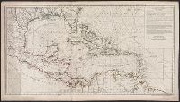
"4 e. feuille.", "No. 5" in lower right corner., Prime meridian: Paris., Relief shown pictorially. Depths shown by soundings., Shows English ownership of Florida., and Stamped no. "107" and title "Golfe du Mexique" on verso. Cross Collection no. 246.
Publisher:
Sur ley Quay de la Megisserie prés le Pont Neuf ...,
Subject (Geographic):
Caribbean Area--Maps--Early works to 1800
Subject (Name):
Buache, Philippe, 1700-1773. Atlas géographique et universel, L'Isle, Guillaume de, 1675-1726. Atlas géographique et universel, and Popple, Henry, -1743
Subject (Topic):
Nautical charts--Caribbean Area--Early works to 1800
Hand col. Mounted on linen. Sheet measures 65 x 49 cm. Ms. n, Has watermarks., Includes index and ill., Oriented with north to the bottom., Relief shown by hachures. Depths shown by soundings., and Shows fortifications and coastal defenses in the Gibraltar region.
Publisher:
Chez Basset, rue St. Jacques, au coin de delle des Mathurins,
Subject (Geographic):
Gibraltar, Bay of (Spain)--Maps--Early works to 1800
Subject (Name):
Coquart, A
Subject (Topic):
Coast defenses--Spain--Gibraltar, Bay of--Maps--Early works to 1800 and Fortification--Spain--Gibraltar, Bay of--Maps--Early works to 1800
Neptune françois, ou, Atlas nouveau des cartes marines.
Description:
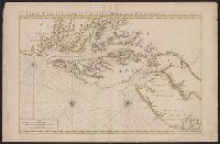
Appears in: Le Neptune françois, ou, Atlas nouveau des cartes marines, various eds., Covers coasts of Virginia, Maryland, Delaware, New, Described in Coolie Verner's Printed maps of Virginia, 1590-1800, p. 402., Nautical chart., and Oriented with north to right.
Publisher:
Chez P. Mortier,
Subject (Geographic):
Middle Atlantic States--Maps--Early works to 1800
Subject (Name):
Mortier, Pierre
Subject (Topic):
Coasts, Coasts--Delaware--Maps--Early works to 1800, Coasts--Maryland--Maps--Early works to 1800, Coasts--New Jersey--Maps--Early works to 1800, and Nautical charts--Chesapeake Bay (Md. and Va.)--Early works to 1800
"No. 66" in upper right corner., Cross Collection no. 256., Depths shown by soundings., Inset: Carte des embouchures du fleuve St. Louis., Prime meridian: Paris., and Relief shown pictorially.
Publisher:
s.n.],
Subject (Geographic):
Gulf Coast (Fla.)--Maps--Early works to 1800
Subject (Name):
France. Dépôt des cartes et plans de la marine
Subject (Topic):
Coasts--Gulf States--Maps--Early works to 1800 and Coasts--Louisiana--Maps--Early works to 1800
Faden, William, 1749-1836 Palmer, W. (William), 1739-1812 Roberts, Henry, Lieut
Published / Created:
1784
Call Number:
23 1784
Container / Volume:
BRBL_00019
Image Count:
1
Resource Type:
Maps, Atlases & Globes
Alternative Title:
Chart of the northwest coast of America and the northeast coast of Asia, explored in the years 1778 and 1779
Description:
Includes notes., Relief shown pictorially. Depths shown by soundings., and Sheet measures 53 x 80.5 cm.
Publisher:
Wm. Faden, geographer to the King, Charing Cross,
Subject (Geographic):
Bering Strait Region--Discovery and exploration--Maps--Early works to 1800, North America--Discovery and exploration--Maps--Early works to 1800, and Pacific Coast (North America)--Discovery and exploration--Maps--Early works to 1800
Subject (Name):
Cook, James,--1728-1779
Subject (Topic):
Discoveries in geography--Maps--Early works to 1800
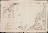
Inset maps: Plano de la Rada de Tanger -- Fondeadero de Funchal -- Plano de la Rada de Sta. Cruz de Tenerife -- Purto de refugio de La Luz -- Casa Blanca ó Dar-El-Beida -- Fondeadero Mazagan -- Mogador -- Rabat y Salé -- Rada de Larache -- Rada de Safi.
Publisher:
Dirección de Hidrografía,
Subject (Geographic):
Canary Islands--Maps, Madeira Islands--Maps, and Morocco--Maps