Skip to search
Skip to main content
Skip to first result
Search
You Searched For
Extent of Digitization
Completely digitized
Format
cartographic
Subject (Topic)
Railroads--United States--Maps
New Search
Search Results
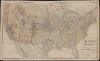
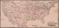
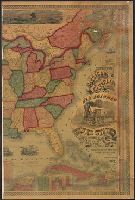
Creator:
Published / Created:
[1882?]
Call Number:
75gme 1882A
Container / Volume:
BRBL_00413
Image Count:
1
Resource Type:
Maps, Atlases & Globes
Alternative Title:
New map of the United States
Description:
Prime meridians: Greenwich and Washington. and Shows major railways west of the Mississippi River.
Publisher:
Rand, McNally,
Subject (Name):
Crofutt, George A. Crofutt's New overland tourist and Pacific coast guide and Overland Publishing Company
Subject (Topic):
Railroads--United States--Maps and Railroads--West (U.S.)--Maps
Found in:
Beinecke Rare Book and Manuscript Library > New map of the United States showing the complete railway system of the trans-Missouri country / prepared expressly for Crofutt's New overland tourist and Pacific coast guide, 1882, the Overland Publishing Company, Omaha, Neb., and Denver, Colo.
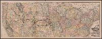
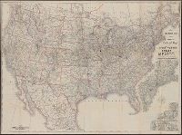
Creator:
Published / Created:
[1912]
Call Number:
80gme 1912B
Container / Volume:
BRBL_00540
Image Count:
1
Resource Type:
Maps, Atlases & Globes
Description:
Covers the northwestern states, Illinois and Wisconsin. and Relief shown by hachures.
Publisher:
Rand McNally & Co.,
Subject (Geographic):
Northwestern States--Maps
Subject (Name):
Chicago, Milwaukee & Puget Sound Railway Company--Maps, Chicago, Milwaukee, and St. Paul Railway Company--Maps, and Tacoma Eastern Railroad--Maps
Subject (Topic):
Railroads--Northwestern States--Maps and Railroads--United States--Maps
Found in:
Beinecke Rare Book and Manuscript Library > Outline map of the lines of the Chicago, Milwaukee & St. Paul Railway Company, Chicago, Milwaukee & Puget Sound Railway Company, and Tacoma Eastern Railway Company : June 30, 1912.
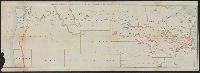
Creator:
Published / Created:
1880
Call Number:
75gme 1880B
Container / Volume:
BRBL_00413
Image Count:
2
Resource Type:
Maps, Atlases & Globes
Alternative Title:
General map of the Pennsylvania Railroad and its connections.
Description:
Inset: Round the World , Across the American Continent, via the Pennsylvania Railroad. and Text and tables on verso: Pennsylvania Railroad Great Trunk Line and U.S. Mail Route, July, 1880.
Publisher:
Allen, Lane & Scott,
Subject (Geographic):
United States--Railroads
Subject (Name):
Pennsylvania Railroad--Maps
Subject (Topic):
Railroads--United States--Maps
Found in:
Beinecke Rare Book and Manuscript Library > Pennsylvania Railroad : Great Trunk Line and U.S. Mail Route.
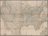
Creator:
Published / Created:
c1889.
Call Number:
75gme 1889
Container / Volume:
BRBL_00414
Image Count:
2
Resource Type:
Maps, Atlases & Globes
Alternative Title:
New official railroad map of the United States, Canada and Mexico.
Description:
Includes 9 insets., Insets: Atlantic Coast states, enlarged scale ; Important cities., Northern Canada and southern Mexico not shown., On verso: Publisher's advertisements., and Relief shown by hachures.
Publisher:
Rand McNally,
Subject (Topic):
Railroads--Canada--Maps, Railroads--Mexico, North--Maps, Railroads--North America--Maps, and Railroads--United States--Maps
Found in:
Beinecke Rare Book and Manuscript Library > Rand McNally & Co.'s new official railroad map of the United States, Canada, and Mexico.
Creator:
Published / Created:
1891, c1889.
Call Number:
75gme 1891
Container / Volume:
BRBL_00414
Image Count:
2
Resource Type:
Maps, Atlases & Globes
Alternative Title:
New official railroad map of the United States, Canada and Mexico.
Description:
Includes 9 insets., Northern Canada and southern Mexico not shown., On verso: Indexes and publisher's advertisements., and Relief shown by hachures.
Publisher:
Rand McNally,
Subject (Topic):
Railroads--Canada--Maps, Railroads--Mexico, North--Maps, Railroads--North America--Maps, and Railroads--United States--Maps
Found in:
Beinecke Rare Book and Manuscript Library > Rand McNally & Co.'s new official railroad map of the United States, Canada, and Mexico.
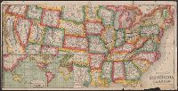
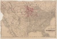
Creator:
Published / Created:
1873
Call Number:
75 1873
Container / Volume:
BRBL_00405
Image Count:
2
Resource Type:
Maps, Atlases & Globes
Description:
Across top of map: "Panoramic view of the country between San Francisco and St. Louis.", Includes ill., text, population information, and inset of "Central America.", Prime meridians: Washington and Greenwich., and Relief shown by hachures.
Publisher:
Geo. F. Cram,
Subject (Geographic):
United States--Maps
Subject (Topic):
Railroads--United States--Maps
Found in:
Beinecke Rare Book and Manuscript Library > The Improved American Union Railroad map of the United States, British provinces, West Indies, Mexico and Central America.
Branch:v1.64.3 ,Deployed:2024-09-25T10:52:58-04:00