"Imprimerie xincographique du Service géographique de l'armée.", Includes key map., Relief shown by contours and shading., and Shows administrative boundaries, railways, roads, principal buildings named.
"Mai 1904.", Relief shown by shading and spot heights. Depths shown by soundings and bathymetric contours., and Shows Guandong Peninsula, southern Liaoning Sheng.
Publisher:
Service géographique de l'Armée,
Subject (Geographic):
Dalian Region (China)--Maps and Lüshun Region (China)--Maps
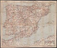
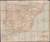
In lower right margin: "5-20"., Insets: [Guipuzcoa/Navarre region] -- [Algeria/Tunisia region]., Relief shown by spot heights., and Shows roads, railroads, rivers, canals and ship routes.
Publisher:
Cartes Taride,
Subject (Geographic):
Portugal--Maps and Spain--Maps
Subject (Topic):
Transportation--Portugal--Maps and Transportation--Spain--Maps
Includes chart showing international commerce in 1906 and 1907., Inset chart showing coffee exports., Inset showing postion on world map., and Map title in Spanish and French.
Includes chart showing international commerce in 1906 and 1907., Inset chart showing coffee exports., Inset showing postion on world map., and Map title in Spanish and French.