Skip to search
Skip to main content
Skip to first result
Search
You Searched For
Extent of Digitization
Completely digitized
Resource Type
Maps, Atlases & Globes
New Search
Search Results
Published / Created:
1910
Call Number:
38 B83 1910
Container / Volume:
BRBL_00156
Image Count:
1
Resource Type:
Maps, Atlases & Globes
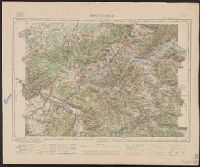
Description:
"Flle. XXXV-18".
Publisher:
Service Géographique de l'Armée,
Subject (Geographic):
Lorraine (France)--Maps
Found in:
Beinecke Rare Book and Manuscript Library > Bruyéres.
Creator:
Published / Created:
[1980]
Call Number:
836 B51 1980
Container / Volume:
BRBL_00592
Image Count:
2
Resource Type:
Maps, Atlases & Globes
Alternative Title:
Bryce Canyon offizieller Führer mit Karte
Description:
"*GPO: 1980--311-309/28.", Includes text and ancillary map of "Bryce Amphitheater trailheads.", Panel title: Bryce Canyon., Relief shown by shading and spot heights., and Text, cross section, and col. ill. on verso.
Publisher:
The Service,
Subject (Geographic):
Bryce Canyon National Park (Utah)--Maps
Found in:
Beinecke Rare Book and Manuscript Library > Bryce Canyon National Park, Utah / National Park Service, U.S. Department of the Interior.
Creator:
Published / Created:
1918
Call Number:
11hcf 1919E-14
Image Count:
1
Resource Type:
Maps, Atlases & Globes
Alternative Title:
Europe 1:1,000,000, G.S.G.S. ; no. 2758, and GSGS (Series) ; no. 2758.
Description:
Includes index to adjoining sheets, index to boundaries, and pronunciation glossary. and Inscription: [Charles] Seymour.
Publisher:
Ordnance Survey,
Subject (Geographic):
Europe, Eastern--Maps
Subject (Name):
Seymour, Charles,--1885-1963--Autograph
Subject (Topic):
World War, 1914-1918--Maps
Found in:
Beinecke Rare Book and Manuscript Library > Bucuresti : North L 35. / compiled at the Royal Geographical Society under the direction of the Geographical Section; drawn and printed by Ordnance Survey.
Creator:
Published / Created:
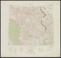
1918
Call Number:
11hcf 1919E-15
Image Count:
1
Resource Type:
Maps, Atlases & Globes
Alternative Title:
Europe 1:1,000,000, G.S.G.S. ; no. 2758, and GSGS (Series) ; no. 2758.
Description:
Elevation above sea level indicated by colored shading., Imperfect. Bled. Inscription: [Charles] Seymour., and Includes index to adjoining sheets, index to boundaries, and pronunciation glossary.
Publisher:
Ordnance Survey,
Subject (Geographic):
Europe, Eastern--Maps
Subject (Name):
Seymour, Charles,--1885-1963--Autograph
Subject (Topic):
World War, 1914-1918--Maps
Found in:
Beinecke Rare Book and Manuscript Library > Bucuresti : North L 35. / compiled at the Royal Geographical Society under the direction of the Geographical Section; drawn and printed by Ordnance Survey.
Branch:v1.61.6 ,Deployed:2024-06-12T09:55:33-04:00