Skip to search
Skip to main content
Skip to first result
Search
You Searched For
Genre
Maps
Publication Place
[Washington, D.C.] :
New Search
Search Results
Creator:
Published / Created:
1913
Call Number:
75ed 1913
Container / Volume:
BRBL_00410
Image Count:
1
Resource Type:
Maps, Atlases & Globes
Alternative Title:
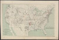
Indian reservations within the limits of the United States
Description:
Insets: Mission Ind. Res. in California. [Scale ca. 1:1,520,640] -- Indian Pueblo grants in New Mexico. [Scale ca. 1:2,534,400] -- Northeastern Oklahoma. [Scale ca. 1:1,520,640].
Publisher:
The Survey,
Subject (Geographic):
United States--Maps
Subject (Topic):
Indian reservations--Maps
Found in:
Beinecke Rare Book and Manuscript Library > Map showing Indian Reservations within the Limits of the United States, 1913 / engraved and printed by the U.S. Geological Survey.
Creator:
Published / Created:
[1897]
Call Number:
75BF 1897
Container / Volume:
BRBL_00407A
Image Count:
1
Resource Type:
Maps, Atlases & Globes
Alternative Title:
Annual report ; eighteenth
Publisher:
USGS,
Subject (Geographic):
United States--Surveys--Maps
Found in:
Beinecke Rare Book and Manuscript Library > Map showing condition and progress of astronomic location, primary triangulation, primary traverse and precise leveling, for the fiscal year 1896-7.
Creator:
Published / Created:
[1897]
Call Number:
75BH 1897
Container / Volume:
BRBL_00407A
Image Count:
1
Resource Type:
Maps, Atlases & Globes
Alternative Title:
Annual Report ; eighteenth
Description:
At head of title: U.S. Geological Survey. Charles D. Walcott, Director.
Publisher:
U.S. Geological Survey,
Subject (Geographic):
United States--Surveys--Maps
Subject (Topic):
Stream-gaging stations--United States--Maps
Found in:
Beinecke Rare Book and Manuscript Library > Map showing condition and progress of topographic surveys and location of gaging stations for the fiscal year 1896-1897.
Creator:
Published / Created:
1935
Call Number:
88 1847H
Container / Volume:
BRBL_00645
Image Count:
1
Resource Type:
Maps, Atlases & Globes
Alternative Title:
Department of State publication ; 803. and Department of State, map series ; no. 5 (Publication no. 803)
Description:
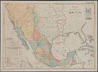
"Reproduced in 1935 to accompany ʻTreaties and other international acts of the United States of America,ʾ Volume 5. See Document 129.", "The earliest of five or more 1847 editions. The copy added to the Treaty of Guadalupe Hidalgo of February 2, 1848, in the archives of the Department of State.", Includes table of distances, table of statistics, "Profile of the route between Mexico and Vera Cruz," and "Profile of the route b[e]tween Mexico and Acapulco.", Insets: Carta de los caminos &c. desde Vera Cruz y Alvarado a Méjico -- Map showing the battle grounds of the 8th and 9th May 1846 -- Chart of the bay of Vera Cruz., Prime meridian: Washington., and Relief shown by hachures and spot heights.
Publisher:
Department of State,
Subject (Geographic):
Mexico--Maps and Southwest, New--Maps
Subject (Name):
A. Hoen & Co and United States. Treaties, etc
Subject (Topic):
United States--Foreign relations--Treaties--Maps
Found in:
Beinecke Rare Book and Manuscript Library > Mapa de los Estados Unidos de Méjico / segun lo organizado y definido por las varias actas del Congreso de dicha República y construido por las mejores autoridades ; lo publican, J. Disturnell.
Creator:
Published / Created:
[1861?]
Call Number:
754 1861C
Container / Volume:
BRBL_00416
Image Count:
1
Resource Type:
Maps, Atlases & Globes
Description:
["Chas. G. Krebs, Lith."], ["Drawn by A. Lindenkohl."], and See Phillips, p. 299.
Publisher:
U.S. Coast Survey,
Subject (Geographic):
Georgia--Maps and South Carolina--Maps
Subject (Name):
Krebs, Charles G and Lindenkohl, A
Found in:
Beinecke Rare Book and Manuscript Library > Middle Georgia & South Carolina.
Creator:
Published / Created:
[ca. 1864]
Call Number:
783hc 1864A
Container / Volume:
BRBL_00512
Image Count:
1
Resource Type:
Maps, Atlases & Globes
Description:
Relief shown by shading.
Publisher:
The Survey,
Subject (Geographic):
North Carolina--Maps and Virginia--Maps
Subject (Name):
Krebs, Charles G, Lindenkohl, H. (Henry), and Rusling, James Fowler, 1834-1918
Found in:
Beinecke Rare Book and Manuscript Library > Middle Virginia and North Carolina / compiled at the U.S. Coast Survey Office, drawn by H. Lindenkohl ; Chas. G. Krebs, lith.
Creator:
Published / Created:
1898
Call Number:
281 1898
Container / Volume:
BRBL_00024
Image Count:
1
Resource Type:
Maps, Atlases & Globes
Description:
Northern sheet wanting. Preliminary record.
Publisher:
War Departmenet,
Subject (Geographic):
Luzon (Philippines)--Maps
Found in:
Beinecke Rare Book and Manuscript Library > Military map of the Isle of Luzon / prepared in the War Department, Adjutant General's Office, Military Information Division ... ; drawn by C.H. Ourand, D.H. Blakelock & E.H. Stück ; Julius Bien & Co., photo. lith., 140 6th Ave. N.Y.
Creator:
Published / Created:
1870
Call Number:
75 1870A
Container / Volume:
BRBL_00404
Image Count:
4
Resource Type:
Maps, Atlases & Globes
Description:
Insets: maps of the Territory of Alaska; [and] West Indies and Isthus of Darien., Prime meridian: Washington., and Relief shown by hachures and spot heights.
Publisher:
Office of the Chief of Engineers, War Department,
Subject (Geographic):
United States--Maps
Subject (Name):
United States. War Dept
Subject (Topic):
Military bases--United States--Maps
Found in:
Beinecke Rare Book and Manuscript Library > Military map of the United States / compiled and drawn by E. Freyhold.
Creator:
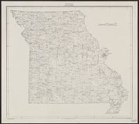
Published / Created:
1934
Call Number:
816fb 1930
Container / Volume:
BRBL_00563
Image Count:
1
Resource Type:
Maps, Atlases & Globes
Description:
"1938-O-65399."
Publisher:
G.P.O.,
Subject (Geographic):
Missouri--Administrative and political divisions--Maps
Found in:
Beinecke Rare Book and Manuscript Library > Missouri : minor civil divisions / Department of Commerce, Bureau of the Census.
Creator:
Published / Created:
1879
Call Number:
831 1879
Container / Volume:
BRBL_00579
Image Count:
1
Resource Type:
Maps, Atlases & Globes
Description:
Prime meridians: Greenwich and Washington. and Relief shown by hachures.
Publisher:
General Land Office,
Subject (Geographic):
Montana--Maps
Subject (Name):
Bien, Julius, 1826-1909 and Roeser, C. (Charles)
Found in:
Beinecke Rare Book and Manuscript Library > Montana Territory / compiled from the official records of the General Land Office and other sources by C. Roeser, principal draughtsman G.L.O.
Branch:v1.61.6 ,Deployed:2024-06-12T09:55:31-04:00