Skip to search
Skip to main content
Skip to first result
Search
You Searched For
Format
cartographic
Publication Place
London :
New Search
Search Results
Creator:
Published / Created:
1800
Call Number:
32 L84 1800C
Container / Volume:
BRBL_00049
Image Count:
3
Resource Type:
Maps, Atlases & Globes
Alternative Title:
One-sheet plan of the cities of London and Westminster with the borough of Southwark
Description:
Includes a "table of references to the churches and principal buildings ..."
Publisher:
Printed for the proprietors, Bowles & Carver,
Subject (Geographic):
London (England)--Maps and Westminster (London, England)--Maps
Found in:
Beinecke Rare Book and Manuscript Library > Bowles's one-sheet plan of the cities of London and Westminster with the borough of Southwark : comprehending their outskirts and extent of the Thames from Chelsea to Deptford : exhibiting also the new buildings, roads and other alterations.
Creator:
Published / Created:
[c1906]
Call Number:
319gme 1906A
Container / Volume:
BRBL_00042
Image Count:
2
Resource Type:
Maps, Atlases & Globes
Description:
"The figures on the map refer to the pages in the guide where the train services are shewn.", Also shows steamship routes and distances., Includes inset of London region and copyright note., and Metropolitan London cab regulations, list of railroad stations in L
Publisher:
Henry Blacklock & Co. Ltd., Engravers and Lithographers,
Subject (Geographic):
British Isles--Maps
Subject (Topic):
Railroad stations--Great Britain--Maps, Railroads--Great Britain--Maps, Railroads--Ireland--Maps, and Steamboat lines--Great Britain--Maps
Found in:
Beinecke Rare Book and Manuscript Library > Bradshaw's railway map of Great Britain and Ireland.
Creator:
Published / Created:
1872
Call Number:
319gme 1872
Container / Volume:
BRBL_00042
Image Count:
2
Resource Type:
Maps, Atlases & Globes
Description:
Inset: London and environs. and Verso: various data.
Publisher:
Bradshaw & Blacklock, London,
Subject (Geographic):
Great Britain--Maps and Ireland--Maps
Subject (Topic):
Railroads--Great Britain--Maps and Railroads--Ireland--Maps
Found in:
Beinecke Rare Book and Manuscript Library > Bradshaw's railway map of Great Britain and Ireland.
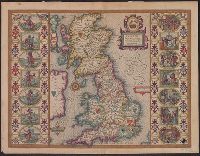
Creator:
Published / Created:
[1612?]
Call Number:
3191 1611
Container / Volume:
BRBL_00732
Image Count:
2
Resource Type:
Maps, Atlases & Globes
Description:
From Speed's The theatre of the empire of Great Britaine., Hand col. Sheet measures 42 x 55 cm. Lanman Collection., Left and right borders contain illustrations of notable persons from each of the 14 political districts., and Running title on verso: Heptarchiae
Publisher:
Are to be sold by John Sudbury & Georg. Humble,
Subject (Geographic):
Great Britain--Maps--Early works to 1800
Subject (Name):
Humble, George, d. 1640, Speed, John, 1552?-1629. Theatre of the Empire of Great Britaine, and Sudbury, John
Found in:
Beinecke Rare Book and Manuscript Library > Britain as it was devided in the tyme of the Englishe Saxons especially during their heptarchy / performed by Iohn Speede and are to be sold by John Sudbury & Georg. Humble, in Popes head alley at Londo[n].
Creator:
Published / Created:
1821
Call Number:
3190 No. 6
Container / Volume:
BRBL_00041
Image Count:
1
Resource Type:
Maps, Atlases & Globes
Description:
London meridian., Note: England Only., Relief shown pictorially., and Shows boundaries, roads and settlements.
Publisher:
Rich. Holmes Laurie,
Subject (Geographic):
England--Maps--Early works to 1800
Subject (Topic):
Romans--England--Maps--Early works to 1800
Found in:
Beinecke Rare Book and Manuscript Library > Britanniæ Antiquæ [cartographic material] : tabula geographica ex ævi Romani monumentis / ab eruditissimo viro Johanne Horsley ... recentissinmus observationibus concinnata.
Published / Created:
[c1925].
Call Number:
739 1925
Container / Volume:
BRBL_00389
Image Count:
1
Resource Type:
Maps, Atlases & Globes
Description:
"221"; "222", "Alexander Gross, F.R.G.S.", and Inset: Minerals.
Publisher:
"Geographia" Ltd.,
Subject (Geographic):
British Columbia--Maps
Found in:
Beinecke Rare Book and Manuscript Library > British Columbia.
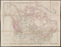
Creator:
Published / Created:
1834
Call Number:
73 1834
Container / Volume:
BRBL_00374
Image Count:
1
Resource Type:
Maps, Atlases & Globes
Description:
"Published Decr. 1st, 1834 ... under the Superintendence of the Society for the Diffusion of Useful Knowledge." and Relief shown by hachures.
Publisher:
Baldwin & Cradock,
Subject (Geographic):
Canada--Maps
Subject (Name):
Baldwin & Cradock and Society for the Diffusion of Useful Knowledge (Great Britain)
Found in:
Beinecke Rare Book and Manuscript Library > British North America / engraved by J. & C. Walker.
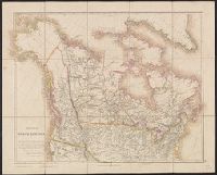
Creator:
Published / Created:
25 April 1859.
Call Number:
73 1859D
Container / Volume:
BRBL_00375
Image Count:
2
Resource Type:
Maps, Atlases & Globes
Description:
In lower right margin: 40., Relief shown by hachures., and Yale's copy with advertisement for "Stanford's series of new library maps" pasted on backing.
Publisher:
J. Arrowsmith,
Subject (Geographic):
Canada--Maps and United States--Maps
Found in:
Beinecke Rare Book and Manuscript Library > British North America : by permission dedicated to the Honble. Hudsons Bay Company, containing the latest information which their documents furnish / by their obedient servant, J. Arrowsmith.
Creator:
Published / Created:
1832 February 15
Call Number:
73 1832
Container / Volume:
BRBL_00374
Image Count:
1
Resource Type:
Maps, Atlases & Globes
Description:
In lower right margin: 39. and Relief shown by hachures.
Publisher:
J. Arrowsmith,
Subject (Geographic):
Canada--Maps and United States--Maps
Found in:
Beinecke Rare Book and Manuscript Library > British North America : by permission dedicated to the Honble. Hudsons Bay Company, containing the latest information which their documents furnish / by their obedient servant, J. Arrowsmith.
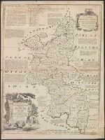
Published / Created:
1756
Call Number:
3227 1756
Container / Volume:
BRBL_00061
Image Count:
1
Resource Type:
Maps, Atlases & Globes
Description:
Preliminary record.
Subject (Geographic):
3227 1788--Maps--Early works to 1800
Found in:
Beinecke Rare Book and Manuscript Library > Buckingham Shire ... Eman: Bowen ... 1756.
Branch:v1.61.6 ,Deployed:2024-06-12T09:55:33-04:00