Skip to search
Skip to main content
Skip to first result
Search
You Searched For
Format
cartographic
Publication Place
London :
New Search
Search Results
Published / Created:
1828
Call Number:
32 1828
Container / Volume:
BRBL_00045
Image Count:
1
Resource Type:
Maps, Atlases & Globes
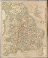
Description:
Preliminary record.
Publisher:
J. Cary,
Subject (Geographic):
England--Maps
Found in:
Beinecke Rare Book and Manuscript Library > Cary's ... map of England and Wales with part of Scotland ... John Cary.
Published / Created:
1824
Call Number:
319 1824
Container / Volume:
BRBL_00040
Image Count:
2
Resource Type:
Maps, Atlases & Globes
Description:
Preliminary record.
Publisher:
J. Cary,
Subject (Geographic):
British Isles--Maps
Found in:
Beinecke Rare Book and Manuscript Library > Cary's Reduction of his 6 sheet map of the British Isles ...
Published / Created:
1918
Call Number:
304fd 1818
Container / Volume:
BRBL_00034B
Image Count:
1
Resource Type:
Maps, Atlases & Globes
Description:
Preliminary record.
Publisher:
G.S.G.S,
Subject (Geographic):
Europe, Central--Maps
Found in:
Beinecke Rare Book and Manuscript Library > Central & South Eastern Europe to illustrate Vienna Congress Treaty.
Published / Created:
1849
Call Number:
898 1849
Container / Volume:
BRBL_00660
Image Count:
1
Resource Type:
Maps, Atlases & Globes
Publisher:
Hydrographic Office of the Admiralty,
Subject (Geographic):
Panama--Maps
Found in:
Beinecke Rare Book and Manuscript Library > Central America Panama Railroad. Surveyed by Col. CW Hughes ...
Published / Created:
[1940]
Call Number:
30gm 1940
Container / Volume:
BRBL_00038
Image Count:
1
Resource Type:
Maps, Atlases & Globes
Publisher:
London Geographical Institute,
Subject (Geographic):
Europe--Maps
Found in:
Beinecke Rare Book and Manuscript Library > Central Europe -- Transport Map.
Published / Created:
[c1925]
Call Number:
304ed 1925
Container / Volume:
BRBL_00034B
Image Count:
1
Resource Type:
Maps, Atlases & Globes
Publisher:
Geographia Ltd.,
Subject (Geographic):
Europe, Central--Maps
Found in:
Beinecke Rare Book and Manuscript Library > Central Europe Ethnographical.
Published / Created:
1873
Call Number:
40 1873
Container / Volume:
BRBL_00202
Image Count:
2
Resource Type:
Maps, Atlases & Globes
Description:
Inset maps: (1) Environs of Naples, [ca. 1:300,000] (2) Part of the Map of North Italy; Island (3) Island of Sicily for the handbook, [ca. 1:1,250,000].
Publisher:
John Murray,
Subject (Geographic):
Italy--Maps
Found in:
Beinecke Rare Book and Manuscript Library > Central and South Italy : to accompany the handbooks for travellers / by J. & C. Walker.
Published / Created:
c1920.
Call Number:
322gm 1920
Container / Volume:
BRBL_00063
Image Count:
2
Resource Type:
Maps, Atlases & Globes
Description:
Verso: Map of the Island of Guernsey ca: 70 000--Map of the Island of Jersey ca: 80 000.
Publisher:
Waterlow & Sons Limited,
Subject (Geographic):
Channel Islands--Maps
Found in:
Beinecke Rare Book and Manuscript Library > Channel Islands and Continental and Ocean Routes in Connection with the South Western Railway.
Creator:
Published / Created:
Feby 18th 1846.
Call Number:
BrSides 2019 96
Image Count:
1
Resource Type:
Maps, Atlases & Globes
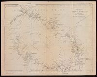
Description:
From John Lort Stokes's Discoveries in Australia (1846)., Lower left-hand corner: :Captn Stokes' considers the meridians marked in this Chart to be 2' too far W.", Relief shown by hachures; depth by bathymetric soundings., and Top right-hand corner: "C. Howe bears N. 36* E (Mag) 170 miles from Kent Group."
Publisher:
Pubd ... by John Arrowsmith, 10 Soho Square,
Subject (Geographic):
Bass Strait (Tas. and Vic.)--Discovery and exploration--Maps. and Bass Strait (Tas. and Vic.)--Maps.
Subject (Name):
Arrowsmith, John, 1790-1873, publisher, Beagle (Ship), and Stokes, John Lort, 1811-1885. Discoveries in Australia.
Subject (Topic):
Discoveries in geography
Found in:
Beinecke Rare Book and Manuscript Library > Chart of Bass' Strait [cartographic material] / surveyed by Capt. I. Lort Stokes & the Officers of H.M.S. Beagle, 1843.
Published / Created:
1854
Call Number:
492cea 1854
Container / Volume:
BRBL_00270
Image Count:
1
Resource Type:
Maps, Atlases & Globes
Alternative Title:
Black Sea
Publisher:
James Wyld,
Subject (Geographic):
Black Sea--Maps
Found in:
Beinecke Rare Book and Manuscript Library > Chart of the Black Sea, the Sea of Azov, and the Sea of Marmora.
Branch:v1.61.6 ,Deployed:2024-06-12T09:55:19-04:00