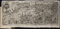
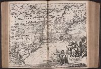
Histoire de la Nouvelle France : contenant les navigations, decouvertes, & habitations faites par
Image Count:
1
Alternative Title:
Figure de la terre neuve, grande ri
Description:
Bound in after p. 236., Depicts coat of arms of Henry IV of France., In pencil on verso: 236., Map has one small hole along fold of second panel at the top., Map has several small brown marks, most notably on the verso., and Scale [ca. 1:9,428,600].
Subject (Geographic):
Acadia --Early works to 1800, America --Discovery and exploration --French --Early works to 1800, New France --Discovery and exploration --Early works to 1800, and New France --Maps --Early works to 1800
Subject (Name):
Millot, Jean, b. 1582, printer, Swelinck, Jan, engraver
, and Villegaignon, Nicolas Durand de, 1510-1571?
Subject (Topic):
Indians of North America --Early works to 1800 and Indians of North America --Nova Scotia --Early works to 1800
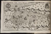
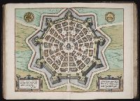
Histoire de la Nouvelle-France : contenant les navigations, decouvertes, & habitations faites par
Image Count:
1
Description:
Bound in after p. 496., In pencil in upper left corner: 497., Map has three or four small brown marks on verso, the largest of which is on the right margin., and Scale not given.
Subject (Geographic):
America --Discovery and exploration --French --Early works to 1800, New France --Discovery and exploration --Early works to 1800, and New France --Maps --Early works to 1800
Subject (Name):
Millot, Jean, b. 1582, printer, Swelinck, Jan, engraver, and Villegaignon, Nicolas Durand de, 1510-1571?
Broeck, Crispin van den, 1524-ca. 1591 Visscher, Nicolaes, 1618-1679
Published / Created:
[ca. 1660]
Call Number:
1983 Folio 19
Collection Title:
[Atlas factice of 96 maps by Blaeu, Visscher, Jansson, Hondius and others]
Image Count:
2
Alternative Title:
Armenia Maior and Asia et Armenia Minor
Description:
Imperfect: illustrations at top cut-out and replaced with ms. titles "Asia et Armenia minor" (upper left) and "Armenia minor" (in upper right); torn along fold and at left edge, with some loss of text. Sheet measures 32 x 47.8 cm. Reinforced along edges with printed waste. No. 85 of 92 maps bound together. and Numbered 91 on verso.
Publisher:
[Nicolaes Visscher]
Subject (Geographic):
Armenia --Maps --Early works to 1800, Assyria --Maps, Egypt --Maps --Early works to 1800, Middle east --Maps --Early works to 1800, Palestine --Geography --Maps --Early works to 1800, Saudi Arabia --Maps, Syria --Maps, and Turkey --Maps
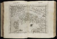
Geografia di Clavdio Tolomeo Alessandrino and Geographia. Italian. 1599
Description:
"Avertimento di Gioseppe Rosaccio, sopra i disegni delle tavole di Tolomeo", leaf 42, 2nd count, has separate caption title., "Della geografia di Clavdio Tolomeo Alessandrino ..." books two through eight, leaves 1 recto-186 recto, 4th count, contain the 27 old in text double maps, on inner forms of leaves with descriptive text. Note that the list of maps in book 1 given on leaves 1 recto and 2 verso do not reflect the cartographic contents within., "Della Geografia di Clavdio Tolomeo Alessandrino", leaves 1-41, 2nd count, has separate caption title., "Descrittione della Geografia vniversale, con tavole qvarantadve d'intaglio di rame, nelle quali secondo u più moderni geografi sono poste le prouincie, regni, città, castelli, monti, fiumi, laghi, porti, golfi, isole, & altre particolarità di tutta la terra; con discorsi fatti da Gioseppe Rosaccio, sopra di ciascuna tauola", leaves 1-144, 3rd count, contain the 41 modern in text double maps, in inner forms of leaves with descriptive text., "Espositioni, et introdvttioni vniversali di Girolamo Rvscelli sopra la Geografia di Clavdio Tolomeo Alessandrini", leaves [1-27], 5th count, has separate dated title page with imprint: In Venetia, M D XCVIII. Appresso gli heredi di Melchior Sessa., "Tavola de' nomi antichi, et moderni di tutte le prouincie, regioni, regni, città, castelli, ville, monti, fiumi, mari, selue, paludi, golfi, isole, capi, popoli, & altre cose notabili, contenute in tutto il presente volume di Tolomeo", leaves [11] recto-[36] verso, 1st count, has separate caption title., "Tavola delle cose piv notabili, che nella Geografia vniversale del Rosaccio si contengono", leaves [5] recto-[10] recto, 1st count, has separate caption title., (Titles of maps bound between leaves 1-144, 3rd count) [1]. Orbis terrae compendiosa descriptio -- [2]. Orbis descriptio -- [3]. Evropa -- [4]. Anglia et Hibernia nova -- [5]. Hispania nova tabvla -- [6]. Gallia nova tabvla -- [7]. Flandra, Brabantia et Holanda nova -- [8]. Tavola nvova di Germania -- [9]. Tavola nvova di Schiavonia -- [10]. Tavola nvova d'Italia -- [11]. Tavola nvova di Piemonte -- [12]. Tavola nvova della Marca d'Ancona -- [13]. Toscana nvova tavola -- [14]. Tavola Nvova di Sardegna et di Sicilia -- [15]. Polonia et Hvngaria nvova tavola -- [16]. Schonladia nvova -- [17]. Tavola nvova di Prvssia et di Livonia -- [18]. Di Hvngaria et Transilvania tavola novissima -- [19]. Graetia nvova tavola -- [20]. Africa -- [21]. Mavritania nvova tavola -- [22]. Africa minor nvova tavola -- [23]. Marmarica nvova tavola -- [24]. Egitto nvova tavola -- [25]. Africa nvova tavola -- [26]. Asia -- [27]. Natolia nvova tavola -- [28]. Soria et Terra Santa nvova tavola -- [29]. Persia nvova tavola -- [30]. Arabia Felice nvova tavola -- [31]. Calecvt nvova tavola -- [32]. India tercera nvova tavola -- [33]. America -- [34]. Tierra nveva -- [35]. Nveva Hispania tabvla nova -- [36]. Tierra nova -- [37]. Brasil nvova tavola -- [38]. Isola Spagnola nova -- [39]. Isola Cvba nova -- [40]. Septentrionalivm partivm nova tabvla -- [41]. Carta marina nvova tavola., (Titles of maps bound between leaves 1-186, 4th count) [1]. Tabvla Evropae I -- [2]. Tabvla Evropae II -- [3]. Tabvla Evropae III -- [4]. Tabvla Evropae IIII -- [5]. Evropae tabvla V -- [6]. Evropae tabvla VI -- [7]. Evropae tabvla VII -- [8]. Evropae tabvla VIII -- [9]. Evropae tabvla IX -- [10]. Tabvla Evropae X -- [11]. Tabvla Aphricae I -- [12]. Tabvla Aphricae II -- [13]. Tabvla Africae III -- [14]. Tabvla Africae IIII -- [15]. Tabvla Asiae I -- [16]. Tabvla Asiae II -- [17]. Tabvla Asiae III -- [18]. Tabvla Asiae IIII -- [19]. Tabvla Asiae V -- [20]. Tabvla Asiae VI -- [21]. Tabvla Asiae VII -- [22]. Tabvla Asiae VIII -- [23]. Tabvla Asiae IX -- [24]. Tabvla Asiae X -- [25]. Tabvla Asiae XI -- [26]. Tabvla Asiae XII -- [27]. Ptolemaei cognita., A quarto edition issued by the heirs of Melchior Sessa in Venice was also printed in 1598., Engraved printer's device on title pages; head and tail pieces; initials; includes in text woodcut diagrams., First printed in Latin in Vicenza in 1475 without maps; the maps from engraved copperplates were first included in the Bologna, 1477 edition., Includes indexes., Inscription on title page: Ex aliij Pajchalij Troije Tea[?]ing Civitatij. Bookplate: Thorne Collection of Cartogaphy and Geography. In vellum binding., Maps show pictorial relief., Roman numeral dated on title pages appear following places of publication., Signatures: *⁴ (*1 verso blank) ²*⁴ ²**² (²**2 verso blank) a-f⁴ g² A-K⁴ L² ²A⁴ ²B⁴ ²C² ²D² ²E-²K⁴ ²L² M⁴ N² O⁴ P-Q² R⁴ S-V² X⁴ Y-Z² 2A-2C² 2D⁴ 2E-2I² 2K⁴ 2L-3N² ³A⁴ ³B-³C² ³D-³E⁴ ³F² ³G-³I⁴ ³K² ³L-³M⁴ ³N-²P² ²Q-²R⁴ ²S² ²T-²X⁴ ²Y² ²Z⁴ ²2A-2B² ²2C-²2D⁴ ²2E² ²2F⁴ ²2G-2H² 2I-2L⁴ ²2M-2P² 2Q-2R⁴ 2S² 2T-2X⁴ 2Y² 2Z⁴ 3A² 3B⁴ 3C-3E⁴ 3F⁴ 3G-3I⁴ 3K⁴ 3L-3M⁴ 3N-3P⁴ (3P4 verso blank) ²a-²e⁴ ³e⁴ ²f⁴ ( -²f4)., Text primarily in Italian; titles and text on maps in Latin and Italian., and This is another edition of the Geografia translated from the Greek by Girolamo Ruscelli, which was first printed in Venice, 1561, here revised, enlarged, and edited by Giuseppe Rosaccio. The maps are the same as those which appeared in the Venice, 1548 edition which had been originally engraved by Giacomo Gastaldi, but have been retouched with new relief of ships and fish. However, according the Shirley, the regional maps in this edition are basically those which originated by Girolamo Puscelli in 1561, with amendments. The world maps consist of the Ptolemaic one dating from 1574 ([27]. Ptolemaei cognita), the original Carta marina ([41]. Carta marina nvova tavola) from the Venice, 1561 edition, and state 2 of the double-hemispherical world map of the Venice, 1561 edition with the addition of a southern continent ([2]. Orbis descriptio). There is also a fourth world map, almost certainly by Rosaccio himself, consisting of two hemispheres enclosed within a plain border ([1]. Orbis terrae compendiosa descriptio), which is a skillfull reproduction of Mercator's map of 1587 but with parallel latitudinals. Five new modern maps have been added to this edition given by Sabin as: map. [3]. Evropa, [18]. Di Hvungaria et Transilvania novissima, [20]. Africa, [26]. Asia, and [33]. America.
Publisher:
Appresso gli heredi di Melchior Sessa,
Subject (Geographic):
America--Geography--Maps
Subject (Name):
Rosaccio, Giuseppe, approximately 1530-approximately 1620, Ruscelli, Girolamo, -approximately 1565, and Thorne Collection of Cartogaphy and Geography Bookplate.
Subject (Topic):
Geography, Ancient--Maps and Mathematical geography
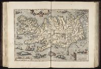
Mecometrie de leymant, cest a dire La maniere de mesvrer les longitudes par le moyen de l’eymant
Image Count:
1
Description:
Bound in preceding t.p. for pt. [2] (Premier livre de la Mecometrie arithmetique de l’eymant)., Imperfect: map rubbed, with some loss of map and text., Map has small tear on left edge at gutter., and Scale [ca. 1:100,000,000].
Subject (Topic):
Longitude --Early works to 1800 and World maps --Early works to 1800
duodecima mensis Iulij anno salutis n[ost]r[a]e. 1493.
Call Number:
1999 Folio 15
Image Count:
7
Alternative Title:
Liber chronicarum, Registrum huius operis libri cronicarum cum in figuris et imagibus ab inicio mundi, Libri cronicarum cu[m] figuris et ÿmagi[ni]bus ab inicio mu[n]di, Libri cronicarum cum in figuris et imagibus ab inicio mundi, Epitoma operu[m] sex dieru[m] de mu[n]di fabrica, and Nuremberg chronicle
Description:
BAC: British Art Center copy bound in 16th-century blind-tooled leather over wood boards. Provenance: Bernhard I, Duke of Saxe-Meiningen, 1649-1706 (with his initials on verso of title page); Paul Mellon., BEIN 1977 Folio 25: Imperfect: some lower margins bled and repaired., BEIN 1977 Folio 25: For fuller description see collation-slip in volume., BEIN 1999 Folio 15: 47 cm. Imperfect: leaves 1, 17, 51, 58, 101, 259, 261, 264, 267, 285, 290 wanting., BEIN 1999 Folio 15: Title page and leaf 268 illuminated., BEIN 2012 Folio 153: Bookplate of A. Hachette., BEIN 2012 Folio 153: For fuller description see collation-slip in volume., BEIN 2012 Folio 154: 49 cm., in case 53 cm. For fuller description see collation-slip in volume., BEIN ZZi 2084: Provenance: Unidentified shelfmarks "1157," "1152," and "11019" (front pastedown). Armorial binding of Paul Petau, with motto: Non est mortale quod opto. Monogram of Alexandre Petau. Autograph and manuscript note of Charles duc de Croy. Autograph of Lalaing. Autograph and armorial bookplate of the Marquises of Ormonde (Ossory), with motto: Comme je trouve (recto front flyleaf). Bibliographical note in modern hand (recto second front flyleaf). Gift of Frank Altschul, 1969., BEIN ZZi 2084: Binding: 45 cm. Mottled calf over paper pasteboards, gold-tooled with arms of Paul Petau and monograph of Alexandre Petau. Spine title: Chronicarum., Imprint from second colophon., Leaves printed on both sides., Unsigned gatherings., First colophon (CCLXVIr): Completo in famosissima Nurembergensi vrbi Operi de hystorijs etatum mundi, ac descriptione vrbium. felix imponitur finis. Collectum breui tempore Auxilio doctoris hartma[n]ni Schedel. qua fieri potuit diligentia. Anno [christ]i Millesimo quadringentesimo nonagesimotercio. die quarto mensis Iunij. Deo igitur optimo. sint laudes infinite., Second colophon ([CCC]v): ADest nunc studiose lector finis libri Cronicarum per viam epithomatis [et] breuiarij compilati opus q[ui]dem preclarum. [et] a doctissimo quoq[ue] comparandum. Continet e[ni]m gesta. quecu[m]q[ue] digniora sunt notatu ab initio mu[n]di ad hanc vsq[ue] te[m]poris nostri calamitatem. Castigatu[m]q[ue] a viris doctissimis vt magis elaboratum in lucem prodiret. Ad intuitu[m] autem [et] preces prouidoru[m] ciuiu[m] Sebaldi Schreyer [et] Sebastiani kamermaister hunc librum dominus Anthonius koberger Nuremberge impressit. Adhibitis tame[n] viris mathematicis pingendiq[ue] arte peritissimis. Michaele wolgemut et wilhelmo Pleydenwurff. quaru[m] solerti acuratissimaq[ue] animaduersione tum ciuitatum tum illustrium virorum figure inserte sunt. Consummatu[m] autem duodecima mensis Iulij. Anno salutis n[ost]re 1493., With two colophons, one dated 4 June 1493, marking the end of the work of Hartmann Schedel; the remainder of the text, with colophon dated 12 July 1493, was the work of Georg Alt. See Wilson, Adrian, The making of the Nuremberg chronicle, 1976, page 156., Printed on Imperial-sized paper; table and parts of text in 2 columns; 64 lines plus headline to a full page; area of text 352 (366) x 223 mm. Includes initial spaces in the table and on leaves i, cclxii, and leaf [iv] (third group); printed initials elsewhere. With foliation, without catchwords and signatures., Signatures (as given by BMC and others): *⁶ **⁶ ***⁸ a⁶ b-d⁴ e-h⁶ i² k⁴ l-n⁶ o² p-q⁶ r-y⁴ z⁶ 2a-2c⁶ 2d² 2e⁶ 2f⁴ 2m-2z⁶ A-K⁶ L⁶⁻² M⁶. The double-leaf map of Europe is printed on leaves L3 and L4, with presentation of the map on L3r and the second colophon on L4v; L5-6 are cancelled. M1r-5v (without foliation) contain "De Sarmacia regione Europe," with Latin sapphics on the exploits of Maximilian on M5v; M6 is blank., Leaves CCLVIIII-CCLXI are blank except for headlines to allow for readers' additions, as noted on CCLVIIIv., Contains 1809 woodcut illustrations (of which 1164 are repeats) by Michael Wolgemut, Wilhelm Pleydenwurff, and Albrecht Dürer, and two woodcut maps., World map printed across leaves XIIv and XIIIr., Variants listed by W.B. Todd, The book collector, 1964, p. 497-98, and in Wilson., and Disputed passage relating to alleged discovery of America by Behaim and Camus on CCXCr.