Skip to search
Skip to main content
Skip to first result
Search
You Searched For
Format
cartographic
Genre
Hand coloring
Genre
Marginalia
New Search
Search Results
Creator:
Published / Created:
[ca. 1758]
Call Number:
1973 Folio 30
Collection Title:
[Atlas factice of 32 maps and 1 distance table, produced by the Homann Erben firm]
Image Count:
2
Publisher:
Anjezo im Verlag bey Tob. Conr. Lotter, Geogr
Subject (Geographic):
Altenburg (Germany : Landkreis) --Maps --Early works to 1800 and Greiz (Germany : Landkreis) --Maps --Early works to 1800
Subject (Topic):
Atlases, German --Early works to 1800
Collection Created:
[Nuremberg : s.n., 1701-1760]
Found in:
Beinecke Rare Book and Manuscript Library > Praefecturae Altenburgensis et Ronneburgensis earumque vicinia serenissimo Duci Saxo Gothano parentes geographica tabula / [cartographic material] / expressae a Matthaeo Seuttero, Geograph. Caesar
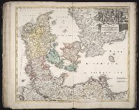
Creator:
Published / Created:
173-?
Call Number:
1973 Folio 30
Collection Title:
[Atlas factice of 32 maps and 1 distance table, produced by the Homann Erben firm]
Image Count:
2
Publisher:
[Johann Baptist Homann]
Subject (Geographic):
Denmark --Maps --Early works to 1800
Subject (Topic):
Atlases, German --Early works to 1800
Collection Created:
[Nuremberg : s.n., 1701-1760]
Found in:
Beinecke Rare Book and Manuscript Library > Regni Daniae, in quo sunt Ducatus Holsatia et Slesvicum, insulae Danicae, provinciae Iutia, Scania, Bleckingia, nova tabula [cartographic material] / edita a Io. Baptista Homanno ; et aucta secundum geographiam novissimam Iohann Huebneri, J.U.L
Creator:
Published / Created:
1741
Call Number:
1973 Folio 30
Collection Title:
[Atlas factice of 32 maps and 1 distance table, produced by the Homann Erben firm]
Image Count:
2
Alternative Title:
Carte de France dressee par Guillaume de L’Isle et accommodee par les Heritiers d’Homann
Publisher:
[Homann Erben]
Subject (Geographic):
France --Maps --Early works to 1800
Subject (Topic):
Atlases, German --Early works to 1800
Collection Created:
[Nuremberg : s.n.,
Found in:
Beinecke Rare Book and Manuscript Library > Regni Galliae seu Franciae et Navarrae [cartographic material] : tabula geographica in usum elementorum geographiae schazianorum accom[m]odata / per Homannianos Heredes
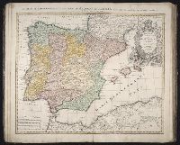
Creator:
Published / Created:
1728?
Call Number:
1973 Folio 30
Collection Title:
[Atlas factice of 32 maps and 1 distance table, produced by the Homann Erben firm]
Image Count:
3
Alternative Title:
Regnorum Hispaniae et Portugalliae tabula generalis de l’Isliana and Reyno de Espanna dividido en dos grandes estados de Aragon y de Castilla, subdividido en muchas provincias donde se halla tambien el Reyno de Portugal
Publisher:
[Homann Erben]
Subject (Geographic):
Portugal --Maps --Early works to 1800 and Spain --Maps --Early works to 1800
Subject (Topic):
Atlases, German --Early works to 1800
Collection Created:
[Nuremberg : s.n.,
Found in:
Beinecke Rare Book and Manuscript Library > Regnorvm Hispaniae et Portvgalliae tabula generalis de l'Isliana / [cartographic material] / aucta et ad usum scholarum novissime accom[m]odata a Ioh. Bapt. Homanno, S.C.M. Geogr.
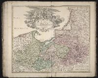
Creator:
Published / Created:
between 1701 and 1709?
Call Number:
1973 Folio 30
Collection Title:
[Atlas factice of 32 maps and 1 distance table, produced by the Homann Erben firm]
Image Count:
2
Publisher:
[Johann Baptist Homann]
Subject (Geographic):
Prussia (Germany) --Maps --Early works to 1800 and Prussia, east (Poland and Russia) --Maps --Early works to 1800
Subject (Topic):
Atlases, German --Early works to 1800
Collection Created:
[Nuremberg : s.n., 1701-1760]
Found in:
Beinecke Rare Book and Manuscript Library > Regnum Borussiae [cartographic material] : gloriosis auspicys serenissimi et potentissimi Prin. Friderici III. Primi Borussiae Regis, March. et Elect. Bran. inauguratum die 18. Ian. a. 1701 / geographice cum vicinis regionibus adumbratum a Ioh. Baptista H
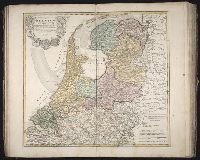
Creator:
Published / Created:
a. 1748
Call Number:
1973 Folio 30
Collection Title:
[Atlas factice of 32 maps and 1 distance table, produced by the Homann Erben firm]
Image Count:
2
Alternative Title:
Septem provinciae seu Belgium Foederatum quod generaliter Hollandia
Publisher:
Edentibus Homannianis Heredibus
Subject (Geographic):
Netherlands --Maps --Early works to 1800
Subject (Topic):
Atlases, German --Early works to 1800
Collection Created:
[Nuremberg : s.n., 1701-1760]
Found in:
Beinecke Rare Book and Manuscript Library > Septem provinciae seu Belgivm Foederatvm quod generaliter Hollandia [cartographic material] : audit speciali mappa delineatum adhibitis auxilium observationibus astronomieis nec non mensurationibus Snellii, Muschenbrokii, etc. / auctore Tobia Mayero ...
Creator:
Published / Created:
[168-]
Call Number:
1973 Folio 10
Image Count:
1
Resource Type:
Maps, Atlases & Globes
Alternative Title:
Kingdom of France divided into all its provinces, comprehended under twelve generall governments viz. ... described by Sanson, corrected and amended by William Berry
Description:
Bar scales given in Italian miles, common leagues of France, great leagues of France, common leagues of Germany, great leagues of Germany, English miles, and common leagues of Spain., Ms. mathematical computations on right margin., No. 12 of 69 maps bound together in composite atlas., Relief shown pictorially., Scale [ca. 1:2 100 000]., and With dedication To the most serene and most sacred Majesty Charles II ... from William Berry.
Publisher:
Sold by William Berry at the sign of the Globe between Charing-Cross and White-Hall
Subject (Geographic):
Europe, Central --Maps --Early works to 1800 and France --Maps --Early works to 1800
Found in:
Beinecke Rare Book and Manuscript Library > The kingdom of France: distinguished according to the extent of all its provinces and conquests in Spain, Italy, Germany, Flanders, Artoise, Haynoult, Namur, and Luxembourg, provinces of the low countries
Published / Created:
1802
Call Number:
Im B388 Zz802B
Collection Title:
The imperial guide : with picturesque plans of the great post roads, containing miniatures
Image Count:
1
Description:
Bound in between p. 4-5. and William Beckford’s copy, with his penciled annotations. Autograph of William Beckford.
Subject (Geographic):
England --Guidebooks, England --Maps, Great Britain --Description and travel --Views, and Great Britain --Road maps
Subject (Topic):
Roads --Great Britain
Collection Created:
London : Printed by C. Whittingham, Dean Street, Fetter Lane, and sold by H.D. Symonds, Paternoster-Row; [etc], 1802
Found in:
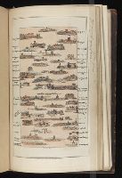
Beinecke Rare Book and Manuscript Library > [Map: Coventry to Stony Stratford]
Published / Created:
1802
Call Number:
Im B388 Zz802B
Collection Title:
The imperial guide : with picturesque plans of the great post roads, containing miniatures
Image Count:
1
Description:
Bound in between p. 38-39. and William Beckford’s copy, with his penciled annotations. Autograph of William Beckford.
Subject (Geographic):
England --Guidebooks, England --Maps, Great Britain --Description and travel --Views, and Great Britain --Road maps
Subject (Topic):
Roads --Great Britain
Collection Created:
London : Printed by C. Whittingham, Dean Street, Fetter Lane, and sold by H.D. Symonds, Paternoster-Row; [etc], 1802
Found in:
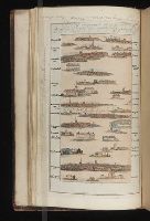
Beinecke Rare Book and Manuscript Library > [Map: Islip to Paddington]
Published / Created:
1802
Call Number:
Im B388 Zz802B
Collection Title:
The imperial guide : with picturesque plans of the great post roads, containing miniatures
Image Count:
1
Description:
Bound in between p. 10-11. and William Beckford’s copy, with his penciled annotations. Autograph of William Beckford.
Subject (Geographic):
England --Guidebooks, England --Maps, Great Britain --Description and travel --Views, and Great Britain --Road maps
Subject (Topic):
Roads --Great Britain
Collection Created:
London : Printed by C. Whittingham, Dean Street, Fetter Lane, and sold by H.D. Symonds, Paternoster-Row; [etc], 1802
Found in:
Beinecke Rare Book and Manuscript Library > [Map: Talk on the Hill to Birmingham]
Branch:v1.61.6 ,Deployed:2024-06-12T09:55:33-04:00