Skip to search
Skip to main content
Skip to first result
Search
You Searched For
Repository
Beinecke Rare Book and Manuscript Library
Language
Latin
New Search
Search Results
Creator:
Published / Created:
[1635]
Call Number:
42 1630
Container / Volume:
BRBL_00244
Image Count:
2
Resource Type:
Maps, Atlases & Globes
Alternative Title:
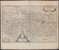
Avstria archidvcatvs
Description:
From Willem and Joan Blaeu's Theatrum orbis terrarum (1635)., In Latin on verso; with caption title "Austria archiducatus" and signature 2X., Relief shown pictorially., and Stamp on verso: Karpinski-von Wieser Map Collection. Sheet measures 47.7 x 56.6 cm.
Publisher:
Guiljelmus Blaeuw excudit,
Subject (Geographic):
Austria--Maps--Early works to 1800
Subject (Name):
Blaeu, Joan, 1596-1673. Theatrum orbis terrarum and Blaeu, Willem Janszoon, 1571-1638. Theatrum orbis terrarum
Found in:
Beinecke Rare Book and Manuscript Library > Austria archiducatus / auctore Wolfgango Lazio.
Published / Created:
1627
Call Number:
41 AU79 1627
Container / Volume:
BRBL_00242
Image Count:
2
Resource Type:
Maps, Atlases & Globes
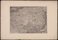
Alternative Title:
Avstria archiducatus
Publisher:
Sumptibus Henrici Hondij,
Subject (Geographic):
Austria--Maps--Early works to 1800 and Hungary--Maps--Early works to 1800
Found in:
Beinecke Rare Book and Manuscript Library > Austria archiducatus / per Gerardum Mercatorem ...
Creator:
Published / Created:
[ca. 1700?]
Call Number:
41 AU79 1700
Container / Volume:
BRBL_00242
Image Count:
1
Resource Type:
Maps, Atlases & Globes
Publisher:
N. Visscher,
Subject (Geographic):
Austria--Maps--Early works to 1800
Subject (Name):
Albany Institute Stamp and Gouwen, Gilliam van der, engraver
Found in:
Beinecke Rare Book and Manuscript Library > Austriae archiducatus pars superior in omnes ejusdem quadrantes ditiones accuratissime et distincte delineata [cartographic material] / per Nic. Visscher.
Published / Created:
[1575?]
Call Number:
41 1575
Container / Volume:
BRBL_00240
Image Count:
1
Resource Type:
Maps, Atlases & Globes
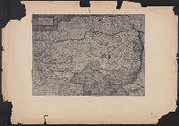
Alternative Title:
Avstriæ dvcatvs sev Pannoniæ svperioris chorographia
Subject (Geographic):
Austria--Maps--Early works to 1800 and Hungary--Maps--Early works to 1800
Found in:
Beinecke Rare Book and Manuscript Library > Austriæ ducatus seu Pannoniæ superioris chorographia ... / a Wolfgango Lazio.
Published / Created:
[1575?]
Call Number:
41 1575
Container / Volume:
BRBL_00240
Image Count:
1
Resource Type:
Maps, Atlases & Globes
Alternative Title:
Avstriæ dvcatvs sev Pannoniæ svperioris chorographia
Subject (Geographic):
Austria--Maps--Early works to 1800 and Hungary--Maps--Early works to 1800
Found in:
Beinecke Rare Book and Manuscript Library > Austriæ ducatus seu Pannoniæ superioris chorographia ... / a Wolfgango Lazio.
Published / Created:
[1643?]
Call Number:
3859 1643
Container / Volume:
BRBL_00181
Image Count:
2
Resource Type:
Maps, Atlases & Globes
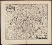
Description:
Verso: Text.
Subject (Geographic):
Auvergne (France)--Maps--Early works to 1800
Found in:
Beinecke Rare Book and Manuscript Library > Auvergne.
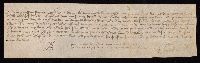
Published / Created:
1428 October 1.
Call Number:
Beinecke MS 712.26
Image Count:
2
Resource Type:
text
Abstract:
Manuscript lease avowal for Jacques de Trie, notarized
Description:
In Latin., Script: French documentary cursive., and Layout: single column of 7 lines, signature and notarial symbol below the text.
Subject (Geographic):
Connecticut and New Haven.
Subject (Topic):
Manuscripts, Medieval
Found in:
Beinecke Rare Book and Manuscript Library > Avowal of lease for Jacques de Trie
Creator:
From the Collection: Voynich, Wilfred Michael, 1865-1930
Published / Created:
1666; 1912-1976
Call Number:
Beinecke MS 408A
Container / Volume:
Box E, Folder 2
Image Count:
52
Found in:
Beinecke Rare Book and Manuscript Library > Wilfred M. Voynich and Ethel Voynich provenance and research files on the Cipher (Voynich) manuscript (Beinecke MS 408A) > Provenance and miscellaneous files > Bacon, Roger
Creator:
Published / Created:
[ca. 1670]
Call Number:
1973 Folio 10
Image Count:
1
Resource Type:
Maps, Atlases & Globes
Description:
Ferro meridian., From Bleau's Atlas major (German ed.). Zu Amsterdam : Bey Johannem Blaeu, [ca. 1670]., No. 58 of 69 maps bound together in composite atlas., Relief shown pictorially., and Scale [ca. 1:4 000 000].
Publisher:
[Joan Blaeu]
Subject (Geographic):
Africa, North --Maps --Early works to 1800
Found in:
Beinecke Rare Book and Manuscript Library > Barbaria
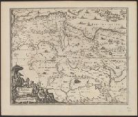
Creator:
Published / Created:
1670]
Call Number:
66 1670
Container / Volume:
BRBL_00347
Image Count:
1
Resource Type:
Maps, Atlases & Globes
Description:
From Ogilby's Africa, being an accurate description of the regions of Egypt, Barbary, Lybia and Billedulgerid. 1670., Has watermarks., Includes ill. and decorative cartouche., and Relief shown pictorially.
Publisher:
Printed by T. Johnson for the author,
Subject (Geographic):
Africa, North--Maps--Early works to 1800
Subject (Name):
Ogilby, John, 1600-1676. Africa, being an accurate description of the regions of Egypt, Barbary, Lybia and Billedulgerid
Found in:
Beinecke Rare Book and Manuscript Library > Barbaria Biledulgerid o: Libye et pars Nigritarum terra.
Branch:v1.61.6 ,Deployed:2024-06-12T09:55:33-04:00