Search
You Searched For
Search Results
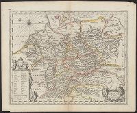
- Creator:
- Keere, Pieter van den, 1571-approximately 1646
- Published / Created:
- [between 1652 and 1684]
- Call Number:
- 36 1630
- Container / Volume:
- BRBL_00117
- Image Count:
- 1
- Resource Type:
- Maps, Atlases & Globes
- Found in:
- Beinecke Rare Book and Manuscript Library > Germaniae veteris nova descriptio / Petrus Kaerius celavit.
- Published / Created:
- [1640?]
- Call Number:
- 36 1640
- Container / Volume:
- BRBL_00117
- Image Count:
- 2
- Resource Type:
- Maps, Atlases & Globes
- Found in:
- Beinecke Rare Book and Manuscript Library > Germaniae veteris typus.
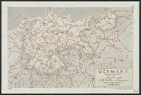
- Creator:
- United States. Office of Strategic Services. Research and Analysis Branch
- Published / Created:
- 1944
- Call Number:
- 36gm 1944A
- Container / Volume:
- BRBL_00130
- Image Count:
- 1
- Resource Type:
- Maps, Atlases & Globes
- Found in:
- Beinecke Rare Book and Manuscript Library > Germany : Super-Highway (Reichsautobahn) / compiled and drawn in the Branch of Research and Analysis, OSS.
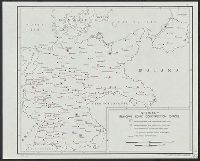
- Creator:
- United States. Office of Strategic Services. Research and Analysis Branch
- Published / Created:
- 1944
- Call Number:
- 36gmb 1944B
- Container / Volume:
- BRBL_00130
- Image Count:
- 1
- Resource Type:
- Maps, Atlases & Globes
- Found in:
- Beinecke Rare Book and Manuscript Library > Germany : principal road construction offices / compiled and drawn in the Branch of Research and Analysis, OSS.
- Creator:
- United States. Army Map Service
- Published / Created:
- 1945
- Call Number:
- 36gm 1945
- Container / Volume:
- BRBL_00130
- Image Count:
- 1
- Resource Type:
- Maps, Atlases & Globes
- Found in:
- Beinecke Rare Book and Manuscript Library > Germany : special strategic map.
- Published / Created:
- 1816
- Call Number:
- 36 1816
- Container / Volume:
- BRBL_00119
- Image Count:
- 1
- Resource Type:
- Maps, Atlases & Globes
- Found in:
- Beinecke Rare Book and Manuscript Library > Germany North of the Mayne. Neele Sc ... London. Drawn & Engraved for Thompson's new General Atlas.
- Published / Created:
- 1816
- Call Number:
- 36 1816A
- Container / Volume:
- BRBL_00119
- Image Count:
- 1
- Resource Type:
- Maps, Atlases & Globes
- Found in:
- Beinecke Rare Book and Manuscript Library > Germany South of the Mayne. Neele Sc ... London. Drawn & Engraved for Thompson's new General Atlas.
- Creator:
- Senex, John, -1740
- Published / Created:
- 1710
- Call Number:
- 36 1710
- Container / Volume:
- BRBL_00683
- Image Count:
- 1
- Resource Type:
- Maps, Atlases & Globes
- Found in:
- Beinecke Rare Book and Manuscript Library > Germany [cartographic material] : corrected from the observations of the Royal Society at London and the Royal Academy at Paris / by John Senex ...
- Creator:
- Darley, James M. (James Morrison)
National Geographic Society (U.S.). Cartographic Section
- Published / Created:
- c1944.
- Call Number:
- 36 1944C
- Container / Volume:
- BRBL_00121
- Image Count:
- 1
- Resource Type:
- Maps, Atlases & Globes
- Found in:
- Beinecke Rare Book and Manuscript Library > Germany and its approaches : with international boundaries as of September 1, 1939, the day Germany invaded Poland and, in red, boundaries as of January 1, 1938, before Germany seized Austria and Czechoslovakia / compiled and drawn in the Cartographic Sec
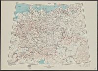
- Creator:
- United States. Office of Strategic Services. Research and Analysis Branch
- Published / Created:
- 1945
- Call Number:
- 36cb 1945A
- Container / Volume:
- BRBL_00127
- Image Count:
- 1
- Resource Type:
- Maps, Atlases & Globes
- Found in:
- Beinecke Rare Book and Manuscript Library > Germany eastern border regions : surface configuration.