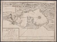
"This map is copied from an original drawn by Monsr. D'Anville ... & published at Paris in 1751. But since the Peace of 1762, that map has been supressed [sic] ... ", Includes descriptive notes,, Prime meridians: Ferro and London., and Relief shown pictorially.
Publisher:
Printed for Robert Sayer in Fleet Street & Thomas Jefferys in the Strand,
Subject (Geographic):
Africa, West--Maps--Early works to 1800, Coasts--Africa, West--Maps--Early works to 1800, and Gambia--Colonization--Maps--Early works to 1800
Subject (Name):
Anville, Jean Baptiste Bourguignon d', 1697-1782 and Sayer, Robert, 1725-1794
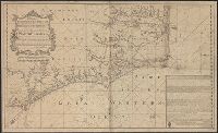
"This map is copied from an original drawn by Monsr. D'Anv, Also appeared in Kitchin's General atlas describing the whole universe. London : Printed for Robert Sayer, [1780]., Prime meridians: Ferro and London., and Relief shown pictorially; depths by soundings.
Publisher:
Printed for Robert Sayer,
Subject (Geographic):
Africa, West--Maps--Early works to 1800
Subject (Name):
Abbot, Charles,--Baron Colchester,--1757-1829--Bookplate, Anville, Jean Baptiste Bourguignon d', 1697-1782, Kitchin, Thomas, d. 1784. General atlas describing the whole universe, and Robert Laurie and James Whittle
Insets: A Plan of the Harbor of St. Augustine, ca. 1:28,000, 20 x 13 cm.; The Mouth of Nassau River, ca. 1:92,000, 11 x 11 cm.; The Mouth of St. Mary's River ca. 1:112,000, 11 x 10 cm.; The Harbor of Port Royal, ca. 1:400,000, 11 x 14 cm.; Charlestown Har
Insets: Plan of the entrance to Port Manoukao -- Plan of Victoria Bay of Islands New Zealand -- Port Nicholson -- Plan of Dusky Bay -- Plan of Southern Port, Stewarts Island -- -Oyerri or Pelorus River -- Plan of the bar and part of the Hokianga River . and Plan of Port Nicholson and Oyerri by permission of the New Zealand Land Company.
Publisher:
James Wyld, geographer to the Queen, Charing Cross East,