Search
You Searched For
Search Results
- Creator:
- Arrowsmith, John, 1790-1873
- Published / Created:
- 1858
- Call Number:
- 36 1858A
- Container / Volume:
- BRBL_00120
- Image Count:
- 1
- Resource Type:
- Maps, Atlases & Globes
- Description:
- "15 Feby.", Map of West Germany with relief shown by hachures., No. in upper right corner of margin: 12., and Shows railroads.
- Publisher:
- J. Arrowsmith,
- Subject (Geographic):
- Germany (West)--Maps
- Subject (Topic):
- Railroads--Germany--Maps
- Found in:
- Beinecke Rare Book and Manuscript Library > Western Germany / by J. Arrowsmith.
- Published / Created:
- 1832
- Call Number:
- 36 1832
- Container / Volume:
- BRBL_00119
- Image Count:
- 1
- Resource Type:
- Maps, Atlases & Globes
- Description:
- Preliminary record.
- Publisher:
- J. Arrowsmith,
- Subject (Geographic):
- Germany--Maps
- Found in:
- Beinecke Rare Book and Manuscript Library > Western Germany By J. Arrowsmith.
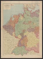
- Creator:
- George Philip & Son
London Geographical Institute
- Published / Created:
- 1940
- Call Number:
- 36 1940A
- Container / Volume:
- BRBL_00121
- Image Count:
- 1
- Resource Type:
- Maps, Atlases & Globes
- Alternative Title:
- Eastern Germany, with Hungary.
- Description:
- Complements Eastern Germany, with Hungary., In lower right margin: The London Geographical Institute., and Relief shown by spot heights.
- Publisher:
- George Philip and Son,
- Subject (Geographic):
- Benelux Countries--Maps, Germany--Maps, and Switzerland--Maps
- Found in:
- Beinecke Rare Book and Manuscript Library > Western Germany, with Holland, Belgium and Switzerland.
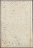
- Creator:
- Great Britain. Hydrographic Dept
J. & C. Walker (Firm)
- Published / Created:
- [1866?]
- Call Number:
- 23cea J328 1861
- Image Count:
- 1
- Resource Type:
- Maps, Atlases & Globes
- Description:
- "Corrections Sept. 1862. March [18]64. Jan. [18]65. May [18]66."
- Publisher:
- The Admiralty,
- Subject (Geographic):
- Java Sea (Indonesia)--Maps
- Subject (Topic):
- Nautical charts--Java Sea
- Found in:
- Beinecke Rare Book and Manuscript Library > Western part of the Java Sea : from Lucipara I. to Sunda Strait and Batavia, corrected to 1861 / engraved by J. & C. Walker.
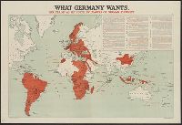
- Published / Created:
- [1916?]
- Call Number:
- BrSides Elephant Folio 2019 3
- Image Count:
- 1
- Resource Type:
- Maps, Atlases & Globes
- Description:
- Date taken from text., In upper right corner: "14.", and Includes inset of quotations describing Germany's war aims.
- Publisher:
- Stanford's Geographical Establishment,
- Subject (Geographic):
- World maps.
- Subject (Topic):
- World War, 1914-1918--Germany--War aims. and World War, 1914-1918--Maps.
- Found in:
- Beinecke Rare Book and Manuscript Library > What Germany wants : her claims as set forth by leaders of German thought.
- Published / Created:
- [1916?]
- Call Number:
- 11hc 1914R
- Container / Volume:
- BRBL_00010B
- Image Count:
- 1
- Resource Type:
- Maps, Atlases & Globes
- Description:
- Date taken from text., In upper right corner: "14.", and Includes inset of quotations describing Germany's war aims.
- Publisher:
- Stanford's Geographical Establishment,
- Subject (Geographic):
- World maps
- Subject (Topic):
- World War, 1914-1918--Germany--War aims and World War, 1914-1918--Maps
- Found in:
- Beinecke Rare Book and Manuscript Library > What Germany wants : her claims as set forth by leaders of German thought.
- Published / Created:
- 1816
- Call Number:
- 32 L84 1816A
- Container / Volume:
- BRBL_00049
- Image Count:
- 1
- Resource Type:
- Maps, Atlases & Globes
- Description:
- Preliminary record.
- Publisher:
- Langley and Belch,
- Subject (Geographic):
- London (England)--Maps
- Found in:
- Beinecke Rare Book and Manuscript Library > William Belch's New Map of London.
- Published / Created:
- 1755
- Call Number:
- 3223 1755
- Container / Volume:
- BRBL_00060
- Image Count:
- 1
- Resource Type:
- Maps, Atlases & Globes
- Description:
- Preliminary record.
- Subject (Geographic):
- Wiltshire (England)--Maps--Early works to 1800
- Found in:
- Beinecke Rare Book and Manuscript Library > Wiltshire ... Eman: Bowen ...
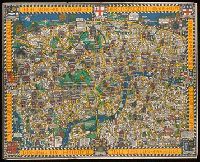
- Published / Created:
- c1914.
- Call Number:
- 32am L84 1914
- Container / Volume:
- BRBL_00075
- Image Count:
- 1
- Resource Type:
- Maps, Atlases & Globes
- Alternative Title:
- Heart of Britain's Empire here is spread out for your view
- Publisher:
- Westminster Press,
- Subject (Geographic):
- London (England)--Maps
- Found in:
- Beinecke Rare Book and Manuscript Library > Wonderground map of the London Town drawn by MacDonald Gill.