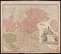
"Cum privilegio Sac. Caes. Majestatis.", Bar scales given in "milliaria Germanica," "milliaria Gallica," and ""milliaria Italica.", Manuscript number in upper right corner: 43. From the Karpinski-von Wieser Map Collection., and Relief shown pictorially.
Publisher:
[Johann Baptist Homann]
Subject (Geographic):
Italy, Northern--Maps--Early works to 1800. and Veneto (Italy)--Maps--Early works to 1800.
Homann, Johann Baptist, 1663-1724 Visscher, Nicolaes, 1649-1702
Published / Created:
1715?]
Call Number:
327 1696
Container / Volume:
BRBL_00072
Image Count:
1
Resource Type:
Maps, Atlases & Globes
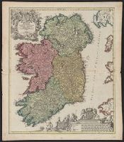
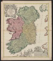
Description:
Bar scales include "milliaria germanica", "milliaria gallica", "milliaria anglica", "milliaria hibernica"., Copy 1: Sheet measures 62.1 x 53.6 cm., Latin and Engli, Relief shown pictorially., and With privilege statement, "Cum privilegio Sac. Caes. Maj."
Homann, Johann Baptist, 1663-1724 Visscher, Nicolaes, 1649-1702
Published / Created:
1715?]
Call Number:
327 1696
Container / Volume:
BRBL_00072
Image Count:
1
Resource Type:
Maps, Atlases & Globes
Description:
Bar scales include "milliaria germanica", "milliaria gallica", "milliaria anglica", "milliaria hibernica"., Copy 2: Sheet measures 61.6 x 54 cm. Ms. nos. on verso: 19; 80., Latin and English., Relief shown pictorially., and With privilege statement, "Cum privileg
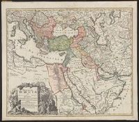
Minimal level cataloging record. and Relief shown pictorially.
Publisher:
Homann,
Subject (Geographic):
Middle East--Maps--Early works to 1800, Turkey--Administrative and political divisions--Maps--Early works to 1800, and Turkey--Maps--Early works to 1800
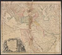
Tabula ex novissimus ad mentem de L'Islii, inprimis vero celeberrimi geographi Dni. I.M. Hasii, Prof. Vitemb. delineata a. 1737
Description:
"Cum privil. S.C.M. Grat.", Bar scales given in "milliaria Germanica," "milliaria Turcica," and "mill. Italica.", Relief shown pictorially., and Variant: without privilege statement in cartouche. Sheet measures 52.5 x 60.4 cm.
Publisher:
[Homann Erben,
Subject (Geographic):
Balkan Peninsula--Maps--Early works to 1800, Egypt--Maps--Early works to 1800, Libya--Maps--Early works to 1800, and Middle East--Maps--Early works to 1800
Subject (Name):
Hase, Johann Matthias, 1684-1742 and Homann Erben (Firm)
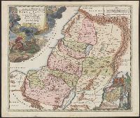
Has watermark., Inset: Populi Isräelitici ex Aegÿpto ... [shows route of the Exodus; Moses and Aaron standing nearby]., Map of Palestine divided among the 12 Tribes, drawn by Homann after Guillaume Sanson. The shoreline runs from Sidon to Rinocorura., and Reli
Publisher:
[Homann,
Subject (Geographic):
Palestine--History--To 70 A.D.--Maps--Early works to 1800 and Palestine--Maps--Early works to 1800
Subject (Name):
Sanson, Guillaume
Subject (Topic):
Bible.--O.T.--Geography--Maps--Early works to 1800
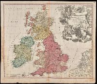
"Cum privilegio S.C.M.", Appeared in Homann's Atlas Novus Terrarum., Prime meridian: Ferro., Relief shown pictorially., Variant with portrait of George I in armour in the cartouche, Plymouth, England spelled correctly, and Delft, Netherlands misspelled "Dolft.", and Watermark. Manuscript number in upper right corner. From the Karpinski-von Wieser Map Collection.
Publisher:
[Johann Baptist Homann]
Subject (Geographic):
British Isles--Maps--Early works to 1800. and Europe--British Isles
Subject (Name):
Homann Erben (Firm) and Homann, Johann Baptist, 1663-1724. Atlas novus terrarum
Homann Erben (Firm) Homann, Johann Baptist, 1663-1724
Published / Created:
ca. 1730]
Call Number:
319 1720
Container / Volume:
BRBL_00040
Image Count:
1
Resource Type:
Maps, Atlases & Globes
Alternative Title:
General map of Great Britain and Ireland with part of Holland, Flanders France &c. agreable to modern history by the heirs of late Mr. Homann at Nuremburg
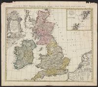
Description:
Graphic scales given in "mill. Anglica" and "milliaria Germ.", Inset, top right: Orcades insulae ... Schetlandicae., Ornate title cartouche, top left, depicting coat of arms and flags., Relief shown pictorially., and Sheet measures 54.5 x 61.9 cm.
Publisher:
Homann Erben,
Subject (Geographic):
Great Britain--Maps--Early works to 1800 and Ireland--Maps--Early works to 1800
Cf. McCorkle, B.B. New England in early printed maps 1513-1800, no. 724.1., Map features New Jersey, New York and New England., Relief represented pictorially., and Sheet measures 51.5 x 60.4 cm.
Publisher:
[s.n.,
Subject (Geographic):
New England--Maps--Early works to 1800, New Jersey--Maps--Early works to 1800, and New York--Maps--Early works to 1800