Skip to search
Skip to main content
Skip to first result
Search
You Searched For
Resource Type
Maps, Atlases & Globes
New Search
Search Results
Published / Created:
1856
Call Number:
49 1856
Container / Volume:
BRBL_00267
Image Count:
1
Resource Type:
Maps, Atlases & Globes
Description:
Shows steamboat lines; countries bordering the Mediterranean with colored politcal boundaries; roads, railroads, caravan routes, etc.; relief show by hachuring. Steel engraving.
Publisher:
Paulis et le Chevalier,
Subject (Geographic):
Mediterranean Region--Maps
Found in:
Beinecke Rare Book and Manuscript Library > Carte du Bassin de la Mer Méditerranée / Dressée par A.H. Dufour, gravée par Ch. Dyonnet.
Creator:
Published / Created:
[1745]
Call Number:
BrSides Double Folio 2019 15
Image Count:
1
Resource Type:
Maps, Atlases & Globes
Description:
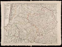
"Avec privilege du 30 Av. 1745"., Imprint below title: "A Paris, chez l'auteur ... 1712. 1. aout"., Prime meridian: Ferro., Relief shown pictorially., Shows abbeys by religious order, priories, pine and other forests, navigable rivers, etc., and Watermark. Sheet measures 53 x 71 cm. Verso: "108" in manuscript.
Publisher:
Ph. Buache ...
Subject (Geographic):
France, Southwest--Maps--Early works to 1800.
Subject (Name):
Buache, Philippe, 1700-1773
Found in:
Beinecke Rare Book and Manuscript Library > Carte du Bearn, de la Bigorre, de l'Armagnac et des pays voisins / par G. Delisle, Premier Geographe du Roy de l'Academie Royale des Sciences.
Published / Created:
1712
Call Number:
3875 1712
Container / Volume:
BRBL_00182
Image Count:
1
Resource Type:
Maps, Atlases & Globes
Publisher:
L'Academie Royal des Sciences,
Subject (Geographic):
Gascony (France)--Maps--Early works to 1800
Found in:
Beinecke Rare Book and Manuscript Library > Carte du Beran de la Bigorre de l'Armagnag et des pays voisins Par Guillaume DeLisle ... 1712.
Published / Created:
[1805?]
Call Number:
491 B65 1805
Container / Volume:
BRBL_00269
Image Count:
1
Resource Type:
Maps, Atlases & Globes
Subject (Geographic):
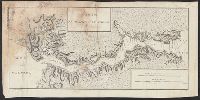
Thrace, Eastern (Turkey)--Maps
Found in:
Beinecke Rare Book and Manuscript Library > Carte du Bosphore de Thrace. Gravé par Thuillier fils. Ecrit par Miller.
Published / Created:
[1650?]
Call Number:
3871 1650
Container / Volume:
BRBL_00181
Image Count:
2
Resource Type:
Maps, Atlases & Globes
Description:
Inset: Principatus Benearnia la Principautus de Bearn ca. 1:250,000., Preliminary record., and Verso: Text.
Publisher:
G. Bleau,
Subject (Geographic):
Médoc (France)--Maps--Early works to 1800
Found in:
Beinecke Rare Book and Manuscript Library > Carte du Bourdelois du pais de Medoc et de la prevaste de Born.
Creator:
Published / Created:
1714
Call Number:
BrSides Double Folio 2019 12
Image Count:
1
Resource Type:
Maps, Atlases & Globes
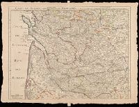
Description:
Relief shown pictorially., Shows forests, etc., and Watermark. Sheet measures 53 x 71 cm. Verso: "107" in manuscript.
Publisher:
Chez l'auteur, quay de l'Horloge
Subject (Geographic):
Dordogne (France)--Maps--Early works to 1800. and France, Southern--Maps--Early works to 1800.
Found in:
Beinecke Rare Book and Manuscript Library > Carte du Bourdelois, du Perigord et des provinces voisines / par G. del'Isle, Premier Géographe du Roy de l'Academie Rle. des Sciences.
Published / Created:
1705
Call Number:
3365 1705
Container / Volume:
BRBL_00089
Image Count:
1
Resource Type:
Maps, Atlases & Globes
Description:
Preliminary record.
Publisher:
Chez L'Auteur ... ,
Subject (Geographic):
Brabant (Belgium)--Maps--Early works to 1800
Found in:
Beinecke Rare Book and Manuscript Library > Carte du Brabant ... Par Guillaume Del'Isle ... Gravé par Liebaux le fils.
Published / Created:
[1835?]
Call Number:
911 1850
Container / Volume:
BRBL_00669
Image Count:
1
Resource Type:
Maps, Atlases & Globes
Description:
From Atlas Universel no. 67.
Publisher:
Institut Geographique de Paris,
Subject (Geographic):
Brazil--Maps
Found in:
Beinecke Rare Book and Manuscript Library > Carte du Brazil et d'une partie des pays limitrophes. Dressée par A. Brué, geographe.
Published / Created:
1756
Call Number:
755 1756A
Container / Volume:
BRBL_00428
Image Count:
1
Resource Type:
Maps, Atlases & Globes
Description:
Inset text: "Description du Canada".
Publisher:
Chez Daumont ... ,
Subject (Geographic):
North America--Maps--Early works to 1800 and United States--History--French and Indian War, 1755-1763--Maps--Early works to 1800
Subject (Topic):
British--North America--Maps--Early works to 1800 and French--North America--Maps--Early works to 1800
Found in:
Beinecke Rare Book and Manuscript Library > Carte du Canada et de la Louisiane qui forment la Nouvelle France et des colonies Angloises ou sont representez les pays contestez ... / par J. B. Nolin ...
Published / Created:
1778
Call Number:
755 1778B
Container / Volume:
BRBL_00432
Image Count:
1
Resource Type:
Maps, Atlases & Globes
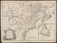
Description:
Insets: Newfoundland, same scale.
Publisher:
Chez Fortin Ingr. mécancien,
Subject (Geographic):
Canada--Maps--Early works to 1800
Found in:
Beinecke Rare Book and Manuscript Library > Carte du Canada et des Etats-Unis de l'Amerique Septentrionale par le Sr. Robert de Vangondy ...
Branch:v1.61.6 ,Deployed:2024-06-12T09:55:33-04:00