Bookplate of Peter E. Keyser. Bookplate signed by P.D. Keyser ... Philadelphia, Pa., Manuscript label on cover: A-24., and Includes ninety-three blanks pages at end.
Subject (Geographic):
Germantown (Philadelphia, Pa.), Pennsylvania, and Philadelphia.
Covers area between Eunice Street and Euclid Avenue [that is, Grizzly Peak Boulevard]., Cadastral map., and Coordinates not present on map and are approximated.
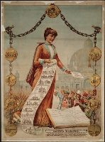
Print advertising opportunities for homes and land in the new state of South Dakota and offers official information from the Commissioner of Immigration in Aberdeen. Primary image is a female figure wearing a tiara labeled "South Dakota" and holding a paper in her left hand that reads "free homes" and in her right hand is a scroll showing images and names of public institutions; at her feet, a book open to the "Record of Progress" in the territory and state of South Dakota, from "permanent white settlement" in 1856 to the first state legislature in 1890. Text below title includes reference to the opening of the Sioux Reservation to homestead settlement
Description:
BEIN BrSides Zc35 890soz 01: Mounted on linen sheet 74 x 54 cm. and Title from caption below image.
Publisher:
F. H. Hagerty, Commissioner of Immigration and Forbes Lith. Mfg. Co.
Subject (Geographic):
South Dakota and Great Sioux Reservation (N.D. and S.D.)
Subject (Topic):
Dakota Indians, Land tenure, Migration, Internal, Real property, Race relations, and Emigration and immigration
Autograph letter, signed, from George Berkeley to Martin Benson providing a brief description of Newport, Rhode Island, 1729 April 11. Berkeley notes the presence of “four sorts of Anabaptists besides Independents, Quakers, and many of no profession at all.” He also writes that he has purchased “a pleasant farm of about one hundred acres” (i.e. “Whitehall,” his plantation at Middletown).
Description:
George Berkeley (1685-1753), Anglo-Irish philosopher. In 1731 September, Berkeley donated his library and his plantation in Newport, Rhode Island, to Yale University. The donation doubled Yale’s library holdings., Martin Benson (1686-1752), English churchman., In English., and Title devised by cataloger.
Subject (Geographic):
Rhode Island., Great Britain., Rhode Island, Newport., Middletown (R.I.), and Newport (R.I.)
Subject (Name):
Benson, Martin, 1689-1752. and Berkeley, George, 1685-1753.
Subject (Topic):
Anabaptists, Philosophers, Plantations, Real property, and Religion
BEIN WA MSS S-3931 M2231: With manuscript letter from Charles Maclay to Newton Booth, dated 3 November 1877. This copy is also cataloged separately as a manuscript with title: Charles Maclay letter, San Fernando, California, to Governor Newton Booth, Sacramento, California, 1877 November 3., Brochure announcing land for sale in San Fernando, Calif., including a map., Title from caption on p. [2]., "San Francisco, [blank] 187[blank]"--P. [1]., Beinecke Library copy includes manuscript letter dated Nov. 3, 1877., "Wm. H. Martin, general agent, San Francisco, Cal."--P. [1]., "Map of the town of San Fernando and the Maclay San Fernando Ranch": p. [4]., and Page [1] has letterhead for California Immigrant Union and large blank space for correspondence.
Publisher:
California Immigrant Union
Subject (Geographic):
California, San Fernando., San Fernando (Calif.), and California, Southern
Two maps on verso: New Artesia, Atascosa County, Texas, founded by Dr. Chas. F. Simmons, 1908 / S.L. Chalk, surveyor (Scale [ca. 1:2,400]); New Pleasanton, Atascosa County, Texas, founded by Dr. Chas. F. Simmons, 1908 / S.L. Chalk, surveyor (Scale [ca. 1:2,400]).
Publisher:
s.n.
Subject (Geographic):
Atascosa County (Tex.), Texas, and Atascosa County
Shows railroads, corporate land ownership, plats of Marquette and Negaunee, sawmill locations in all or parts of sections T.47-48 N, R. 25-27 W.
Description:
Backed with linen. Manuscript annotations on map. Manuscript title on verso: Marquette Iron Region. From the Richard H. Rickard Papers., Coordinates not present on map and are approximated., Detached from: A statement of the plan of the St. Mary's Canal Mineral Land Company (New York : Baker & Godwin, printers, 1859)., and Relief shown by hachures.
Publisher:
[Baker & Godwin, printers],
Subject (Geographic):
Michigan--Upper Peninsula
Subject (Name):
Collins Iron Company--Maps., Excelsior Iron Company--Maps., Jackson Iron Company (Fayette, Mich.)--Maps., Peninsula Iron Company--Maps., Pioneer Iron Company--Maps., and Rickard, Richard H.,---1885--Owner
Subject (Topic):
Iron mines and mining, Iron mines and mining--Michigan--Upper Peninsula--Maps., Real property, and Real property--Michigan--Upper Peninsula--Maps.
Relief shown by shading and spot heights. Soundings in feet., Shows drainage, school districts, township boundaries, land ownership, tract numbers, ranchos, acreages, township and section lines, railroads, etc., Insets: Geographical map of Alameda County and the surrounding counties. Scale [1:380,160]. 6 miles (480 chains) to the in. -- Map of the city of Oakland. Scale [1:7,920]. 10 chains (660 ft.) to the in. -- Southeast corner of Alameda County, east of the line AB [continuation of map]., Includes table of supervisors and supervisor districts., BEIN Covers 844 Al11 +1874: Mounted on linen. In cover with title "Allardt's official map of Alameda County.", and BEIN 844 Oa5 1874 Copy 2: Imperfect: chipped and torn, with some loss of text. Eastern sheets only.
Publisher:
G.F. Allardt, Britton, Rey & Co., lith.)
Subject (Geographic):
California, Alameda County, Oakland, Alameda County (Calif.), and Oakland (Calif.)