Skip to search
Skip to main content
Skip to first result
Search
You Searched For
Format
cartographic
New Search
Search Results
Creator:
Published / Created:
[1739?]
Call Number:
1973 folio 44
Collection Title:
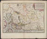
Plan de Paris commence l’annee 1734. Dessine et gravesous les ordres de Messire Michel Etienne
Image Count:
1
Resource Type:
Maps, Atlases & Globes
Description:
Consists of 20 numbered sectional plans of Paris. and Scale about 1:1800.
Subject (Geographic):
Paris (France) --Maps
Subject (Topic):
Architecture --France --Paris
Collection Created:
[Paris? 1739?]
Found in:
Beinecke Rare Book and Manuscript Library > [Untitled sectional plan of Paris]
Creator:
Published / Created:
[1739?]
Call Number:
1973 folio 44
Collection Title:
Plan de Paris commence l’annee 1734. Dessine et grave sous les ordres de Messire Michel Etienne
Image Count:
1
Resource Type:
Maps, Atlases & Globes
Description:
Consists of 20 numbered sectional plans of Paris. and Scale about 1:1800.
Subject (Geographic):
Jardin des Tuileries (Paris, France), Paris (France) --Maps, and Tuileries Palace (Paris, France)
Subject (Topic):
Architecture --France --Paris
Collection Created:
[Paris? 1739?]
Found in:
Beinecke Rare Book and Manuscript Library > [Untitled sectional plan of Paris]
Published / Created:
1916?].
Call Number:
38 V58 1916
Container / Volume:
BRBL_00166
Image Count:
1
Resource Type:
Maps, Atlases & Globes
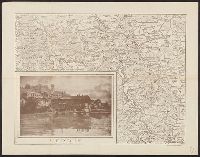
Description:
In bottom right margin: "Cliché dell'Officina Romana." and Inset view of Verdun.
Publisher:
s.n.,
Subject (Geographic):
Verdun (France)--Maps
Found in:
Beinecke Rare Book and Manuscript Library > [Verdun and Environs].
Published / Created:
1916?]
Call Number:
38am V58 1916
Container / Volume:
BRBL_00168
Image Count:
1
Resource Type:
Maps, Atlases & Globes
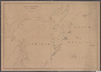
Description:
In bottom left corner: "G.M".
Publisher:
s.n.,
Subject (Geographic):
Lorraine (France)--Maps and Verdun (France)--Maps
Found in:
Beinecke Rare Book and Manuscript Library > [Verdun and Environs].
Published / Created:
[1940?]
Call Number:
38gmp B833 1940
Container / Volume:
BRBL_00171
Image Count:
1
Resource Type:
Maps, Atlases & Globes
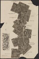
Description:
Aerial photograph of portion of Bruges railway., Imperfect: Frayed with loss of text., and Title supplied by cataloger.
Publisher:
Advanced Section, Army Printing and Stationery Service,
Subject (Geographic):
Belgium--Maps
Found in:
Beinecke Rare Book and Manuscript Library > [View taken above Bruges].
Published / Created:
1855
Call Number:
811ca 1855
Container / Volume:
BRBL_00554
Image Count:
1
Resource Type:
Maps, Atlases & Globes
Description:
"Entered according to act of Congress by E.J. Hulbert in the year 1855 in the Clerk's Office of the District Court of the United States for the State of Michigan". and Imperfect: Mutilated with some loss of text.
Publisher:
s.n.,]
Subject (Geographic):
Michigan--Maps
Found in:
Beinecke Rare Book and Manuscript Library > [Western part of upper peninsula, Michigan].
Branch:v1.62.0 ,Deployed:2024-06-26T09:56:55-04:00