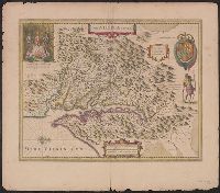
Hand col. Sheet measures 50.8 x 58.2 cm. Cross Collection no. 213., Hendrik Hondius' derivative of John Smith's map of Virginia, 1612., In Latin on verso, with running and caption title "Virginia," signature 4R, and catchword "fluvio-"., Oriented with north toward the right., Relief shown pictorially., and Royal arms in upper right.
Publisher:
Ex officina Henrici Hondii,
Subject (Geographic):
Chesapeake Bay (Md. and Va.)--Maps--Early works to 1800, Maryland--Maps--Early works to 1800, and Virginia--Maps--Early works to 1800
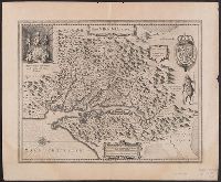
Hendrik Hondius' derivative of John Smith's map of Virginia, 1612., Oriented with north to the right., Relief shown pictorially., Sheet measures 47.6 x 57.7 cm. Franklin Collection no. 131 1633., and Verso in French, with running and caption title "Description de la Virginie," signatures 8O2, and catchword "peu".
Publisher:
Ex officina Henrici Hondii,
Subject (Geographic):
Chesapeake Bay (Md. and Va.)--Maps--Early works to 1800, Maryland--Maps--Early works to 1800, and Virginia--Maps--Early works to 1800
Subject (Name):
Jansson, Jan, 1588-1664. Atlas novus. French and Smith, John, 1580-1631
"Amstelodami cum privilegio D.D. ordin. Hollandiae Westfrisiaeq[ue].", Backed with paper., Illustrated hand colored title cartouche; sea decorated with ships., Prime meridian: Ferro., and Relief shown pictorially.
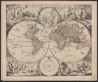
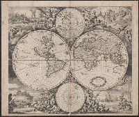
Allegorical vignettes of the four seasons., Cf. Shirley, R. Mapping of the world, no. 545., Cross Collection no. 25., and Double hemisphere, with smaller polar insets.
Imperfect: mutilated along folds, with some loss of text. Cross collection no. 24., Includes ill. and ancillary maps of north and south polar regions., and Relief shown pictorially.
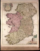
"Cum privilegio.", Backed with paper. Ms. no. "49" in lower-right corner. Sheet measures 63.1 x 53.8 cm. No. 46 of 87 maps bound together., Includes four bar scales., Prime meridian: Ferro., Relief shown pictorially., and Watermark.
Publisher:
[Peter Schenk,
Subject (Geographic):
Ireland--Maps--Early works to 1800.
Subject (Name):
Schenk, Peter, 1660-1718 or 1719. Atlas contractus.
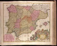
"Cum privil. Regis Polon. et Elect. Sax. et Hollandiae et Westfrisiae.", Backed with paper. Ms. no. "63" in upper right-hand corner. Sheet measures 53.5 x 62.3 cm. No. 58 of 87 maps bound together., Bar scales given in "milliaria Germanica," "milliaria Hispanica," and "mill. Gallica.", Prime meridian: Ferro., Relief shown pictorially., and Watermark.
Publisher:
[Peter Schenk],
Subject (Geographic):
Portugal--Maps--Early works to 1800. and Spain--Maps--Early works to 1800.
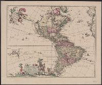
"Cum Privilegio D.D. Ordinum Holl. Westfriliegs.", Appears in various editions of Wit's Atlas., Includes note, "America" in ornamental cartouche., Mounted on linen. Sheet measures 50 x 60.5 cm. Cross Collection no. 135., Prime meridian: Ferro., Relief shown pictorially., Shows the Western Hemisphere with national boundaries, cities and rivers; shows California as an island., Text in Latin., and Title from ornamental cartouche.
Publisher:
Ex officina I. Covens et C. Mortier,
Subject (Geographic):
America--Maps--Early works to 1800 and Western Hemisphere--Maps--Early works to 1800
"Cum privilegio.", Author is either Justus Danckerts the younger (d. 1692) or Justus Danckerts the elder (1635-1701)., Hand col. Sheet measures 53 x 62 cm. Ms. no. on verso: 4., Includes decorative cartouche., and Relief shown pictorially.