Skip to search
Skip to main content
Skip to first result
Search
You Searched For
Format
cartographic
Language
German
Publication Place
London :
New Search
Search Results
Published / Created:
[1894]
Call Number:
643 W782 1894
Container / Volume:
BRBL_00340
Image Count:
1
Resource Type:
Maps, Atlases & Globes
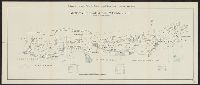
Description:
"Beilage zu 'Die neue Aera der Witwatersrand-Goldindustrie' von Felix Abraham (1894).", German and English., and Shows mine holding areas by owner.
Publisher:
Waterlow & Sons,
Subject (Geographic):
Witwatersrand (South Africa)--Maps
Subject (Name):
Abraham, Felix. Neue Aera der Witwatersrand-Goldindustrie. 1894
Subject (Topic):
Gold mines and mining--South Africa--Witwatersrand--Maps, Mining leases--South Africa--Witwatersrand--Maps, and Real property--South Africa--Witwatersrand--Maps
Found in:
Beinecke Rare Book and Manuscript Library > Mittleres Grubenfeld des Witwatersrands (von May Cons. bis United Langlaagte).
Creator:
Published / Created:
[1877]
Call Number:
30an 1877B
Container / Volume:
BRBL_00037
Image Count:
1
Resource Type:
Maps, Atlases & Globes
Description:
Countries are represented by drawings of people, animals, etc. to depict political issues. and Includes English and German text.
Publisher:
G.W. Bacon & Co.,
Subject (Geographic):
Europe--Maps, Pictorial and Europe--Politics and government--Maps, Pictorial
Subject (Topic):
Russo-Turkish War, 1877-1878--Maps
Found in:
Beinecke Rare Book and Manuscript Library > Serio-comic war map for the year 1877 / by F.W. Rose.
Published / Created:
1840
Call Number:
90 1840
Container / Volume:
BRBL_00663
Image Count:
1
Resource Type:
Maps, Atlases & Globes
Description:
Drawn & Engraved by J. Dower.
Publisher:
William Orr,
Subject (Geographic):
South America--Maps
Found in:
Beinecke Rare Book and Manuscript Library > South America. Drawn & Engraved by J. Dower.
Creator:
Published / Created:
[1862]
Call Number:
32 L84 1862
Container / Volume:
BRBL_00050
Image Count:
1
Resource Type:
Maps, Atlases & Globes
Alternative Title:
Neuer Plan von London and Nouveau plan de Londres
Description:
Border includes engravings of prominent structures., Imperfect: mutilated with loss of text., and Map in English; some data also in French and German.
Publisher:
Published by James Wyld, Geographer to the Queen and H.R.H. Prince Albert,
Subject (Geographic):
London (England)--Maps
Found in:
Beinecke Rare Book and Manuscript Library > Wyld's new plan of London = Nouveau plan des Londres = Neuer Plan von London.
Branch:v1.61.6 ,Deployed:2024-06-12T09:55:36-04:00