Search
You Searched For
Search Results
- Creator:
- Marion, Israel
- Published / Created:
- 1888
- Call Number:
- 739 1888
- Container / Volume:
- BRBL_00388
- Image Count:
- 1
- Resource Type:
- Maps, Atlases & Globes
- Found in:
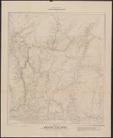
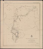
- Beinecke Rare Book and Manuscript Library > Map of a portion of the southern Interior of British Columbia : embodying the explorations made in 1877 by G.M. Dawson, and in 1882-4 by Amos Bowman / drawn by Israel Marion.
- Creator:
- Marion, Israel
- Published / Created:
- 1888
- Call Number:
- 739 1888
- Container / Volume:
- BRBL_00388
- Image Count:
- 1
- Resource Type:
- Maps, Atlases & Globes
- Found in:
- Beinecke Rare Book and Manuscript Library > Map of a portion of the southern Interior of British Columbia : embodying the explorations made in 1877 by G.M. Dawson, and in 1882-4 by Amos Bowman / drawn by Israel Marion.
- Creator:
- Ludlow, William, 1843-1901
- Published / Created:
- [1874?]
- Call Number:
- 821 1874
- Container / Volume:
- BRBL_00566
- Image Count:
- 1
- Resource Type:
- Maps, Atlases & Globes
- Found in:
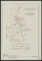
- Beinecke Rare Book and Manuscript Library > Map of a reconnaissance of the Black Hills, July and August, 1874, with troops under command of Lt. Col. G.A. Custer, 7th Cavalry / by Capt. Wm. Ludlow, Corps of Engineers.
- Creator:
- Wislizenus, F. A. (Frederick Adolph), 1810-1889
- Published / Created:
- 1848]
- Call Number:
- 796 1848A
- Container / Volume:
- BRBL_00524
- Image Count:
- 1
- Resource Type:
- Maps, Atlases & Globes
- Found in:
- Beinecke Rare Book and Manuscript Library > Map of a tour from Independence to Santa Fé, Chihuahua, Monterey and Matamoros / by A. Wislizenus, in 1846 and 1847 ; lith. by E. Weber & Co.
- Creator:
- Van Loan, Walton
- Published / Created:
- 1877
- Call Number:
- 771 C29 1877
- Container / Volume:
- BRBL_00481
- Image Count:
- 1
- Resource Type:
- Maps, Atlases & Globes
- Found in:
- Beinecke Rare Book and Manuscript Library > Map of all points of interest within four miles of the Catskill Mountain House with roads and foot paths / surveyed and drawn by Walton Van Loan.
- Creator:
- Trautwine, John C. (John Cresson), 1810-1883
- Published / Created:
- 1852]
- Call Number:
- 89 1866F
- Container / Volume:
- BRBL_00658
- Image Count:
- 1
- Resource Type:
- Maps, Atlases & Globes
- Found in:
- Beinecke Rare Book and Manuscript Library > Map of an exploration for an inter-ocean canal by way of the Rivers Atrato and San Juan in New Granada, S.A. / laid down from observations made by John C. Trautwine, c.e., in 1852 ; Bowen & Co. lith, Phila.
- Creator:
- United States. Adjutant-General's Office. Military Information Division
- Published / Created:
- [1898]
- Call Number:
- 855hc 1898G
- Container / Volume:
- BRBL_00765
- Image Count:
- 1
- Resource Type:
- Maps, Atlases & Globes
- Found in:
- Beinecke Rare Book and Manuscript Library > Map of battle field of August 10th 1898 : between U.S. regular troops under Brig. Genl. Theodore Schwan, U.S. Volunteers and Spanish forces under Col. Julio Soto Villanueva, Alfonso XIII.
- Published / Created:
- [1861]
- Call Number:
- 783hc B87 1861B
- Container / Volume:
- BRBL_00512
- Image Count:
- 1
- Resource Type:
- Maps, Atlases & Globes
- Found in:
- Beinecke Rare Book and Manuscript Library > Map of battles of Bull Run, near Manassas, on the line of Fairfax and Prince William Coes.
- Published / Created:
- 1870
- Call Number:
- 766 N46 1870D
- Container / Volume:
- BRBL_00471
- Image Count:
- 1
- Resource Type:
- Maps, Atlases & Globes
- Found in:
- Beinecke Rare Book and Manuscript Library > Map of building lots for sale at Edgewood, near New Haven.