Skip to search
Skip to main content
Skip to first result
Search
You Searched For
Date
1800 - 1999
Publication Place
London :
Date Created
1800 to 1999
New Search
Search Results
Creator:
Published / Created:
[1878]
Call Number:
BrSides Folio 2019 91
Image Count:
1
Resource Type:
Maps, Atlases & Globes
Description:
"E.L.B. & R.N.C. 1878 no. 2.", Includes inset map of Magadascar., Issued to accompany: A sketch of the modern languages of the East Indies / by Robert Needham Cust. 1878., and Relief shown by hachures and spot heights.
Publisher:
Stanford's Geogl. Estabt.,
Subject (Geographic):
Southeast Asia--Languages--Maps.
Subject (Name):
Cust, Robert Needham, 1821-1909. Sketch of the modern languages of the East Indies.
Subject (Topic):
Language and languages.
Found in:
Beinecke Rare Book and Manuscript Library > A language map of further India and the Indian archipelago [cartographic material].
Creator:
Published / Created:
[1818]
Call Number:
71 1818A
Container / Volume:
BRBL_00368
Image Count:
4
Resource Type:
Maps, Atlases & Globes
Description:
In lower margin: London: Published 1 Jan. 1795 by A. Arrowsmith, No. 10 Soho Square ... additions to 1802., Includes notes., and Relief shown by hachures.
Publisher:
A. Arrowsmith,
Subject (Geographic):
North America--Maps
Found in:
Beinecke Rare Book and Manuscript Library > A map exhibiting all the new discoveries in the interior parts of North America : inscribed by permission to the honourable governor and company of adventurers of England trading into Hudsons Bay in testimony of their liberal communications to their most
Creator:
Published / Created:
1801
Call Number:
73 1801
Container / Volume:
BRBL_00374
Image Count:
1
Resource Type:
Maps, Atlases & Globes
Description:
"... Published 15 Oct. 1801 ...", Relief shown by hachures., and Yale's copy 1 with ms. note in ink in bottom margin. Also stamped, "Yale, Horace Brown, 1900S."
Publisher:
Published by Alexander Mack Kenzie,
Subject (Geographic):
Canada--Discovery and exploration--Maps and Canada--Maps
Subject (Name):
Mackenzie, Alexander,--1764-1820--Travel--Maps
Found in:
Beinecke Rare Book and Manuscript Library > A map of America between latitudes 40 and 70 north and longitudes 45 and 180 west exhibiting Mackenzie's track from Montreal to Fort Chipewyan & from thence to the north sea in 1789 & to the west Pacific Ocean in 1793.
Creator:
Published / Created:
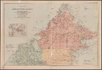
1903
Call Number:
2732 1903
Container / Volume:
BRBL_00023B
Image Count:
1
Resource Type:
Maps, Atlases & Globes
Description:
Covers Brunei, Sabah, and northern Sarawak., Includes inset location map., Land available for sale or sold indicated., Library copy accompanied by manuscript notes., and Relief shown by hachures and spot heights. Soundings in fathoms.
Publisher:
Published by Edward Stanford for the British North Borneo Company,
Subject (Geographic):
Brunei--Maps, Sabah--Maps, and Sarawak--Maps
Subject (Name):
British North Borneo Chartered Company
Found in:
Beinecke Rare Book and Manuscript Library > A map of British North Borneo / compiled from the English Admiralty charts and from the surveys and explorations of F.X. Witti, W.B. Pryer, F. Hatton, Henry Walker, D.D. Daly, and R.D. Beeston in the service of the British North Borneo Company.
Creator:
Published / Created:
1911
Call Number:
56 1911
Container / Volume:
BRBL_00296
Image Count:
1
Resource Type:
Maps, Atlases & Globes
Alternative Title:
Map of China showing the stations of the China Inland Mission
Description:
"China Inland Mission stations with resident missionary are underlined in red.", "Stanford's Geog! Estab., London.", and Covers on verso not digitized.
Publisher:
China Inland Mission, Newington Green, N.,
Subject (Geographic):
China--Religion--Maps
Subject (Name):
Edward Stanford Ltd
Found in:
Beinecke Rare Book and Manuscript Library > A map of China [cartographic material] : prepared for the China Inland Mission.
Published / Created:
[1845?]
Call Number:
3191 1845
Container / Volume:
BRBL_00041
Image Count:
1
Resource Type:
Maps, Atlases & Globes
Description:
Preliminary record.
Publisher:
James Wyld,
Subject (Geographic):
Great Britain--Maps
Found in:
Beinecke Rare Book and Manuscript Library > A map of England, Wales, & Scotland ...
Published / Created:
[1852?]
Call Number:
327 1852
Container / Volume:
BRBL_00073
Image Count:
1
Resource Type:
Maps, Atlases & Globes
Description:
Preliminary record.
Publisher:
James Wyld,
Subject (Geographic):
Ireland--Maps
Found in:
Beinecke Rare Book and Manuscript Library > A map of Ireland ... with the distances of the principal towns from Dublin ...
Creator:
Published / Created:
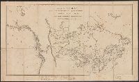
1814
Call Number:
80 1814
Container / Volume:
BRBL_00532
Image Count:
1
Resource Type:
Maps, Atlases & Globes
Description:
Includes text., Prime meridians: London and Washington., and Relief shown by hachures.
Publisher:
Longman, Hurst, Rees, Orme & Brown,
Subject (Geographic):
Northwestern States--Maps
Subject (Name):
Clark, William, 1770-1838, Lewis and Clark Expedition--(1804-1806)--Maps, Longman, Hurst, Rees, Orme, and Brown, and Neele & Son
Found in:
Beinecke Rare Book and Manuscript Library > A map of Lewis and Clark's track across the western portion of North America, from the Mississippi to the Pacific Ocean : by order of the executive of the United States in 1804, 5 & 6 / copied by Samuel Lewis from the original drawing of Wm. Clark ; Neele
Published / Created:
1804
Call Number:
3655 1804
Container / Volume:
BRBL_00144
Image Count:
1
Resource Type:
Maps, Atlases & Globes
Description:
2 copies.
Publisher:
Wm. Faden,
Subject (Geographic):
Schleswig-Holstein (Germany)--Maps
Found in:
Beinecke Rare Book and Manuscript Library > A map of the Dutchy of Holstein ...
Branch:v1.61.8 ,Deployed:2024-06-20T11:15:02-04:00