Mappa Aestivarvm insularum, alias Barmvdas dictarum
Description:
Below map, list of proprietors in 12 columns flanked by coats-of-arms., Borders are hand colored., and Not hand colored. With watermark. Sheet measures 46 x 55 cm.
Charte worauf in einem Begriff und Anblick alle natürliche politische und Kunst-termini oder Wörter benen̄et.
Description:
1an, Demonstrates cartographic terms, symbols, depictions of landforms, etc., Has watermark., Relief shown pictorially., and Title in upper margin: Charte worauf in einem Begriff und Anblick alle natürliche politische und Kunst-termini oder Wörter benen̄et ...
Publisher:
Matthaeo Seutter,
Subject (Topic):
Cartography--Germany, Cartography--Methodology--Maps, Imaginary places--Maps--Early works to 1800, Maps--Symbols, and Maps--Terminology
Title from item., Date supplied by curator., Place of publication derived from language of text., and This electronic record is derived from historic data and may not reflect our current information. Review and updating of records is ongoing.
Publisher:
publisher not identified
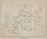
Subject (Geographic):
Mariánské Lázně (Czech Republic). and Germany
Subject (Topic):
Hydrotherapy, Monkeys, Eating & drinking, Swine, Cats, Donkeys, Priests, Pilgrims, Bathing, Hangings (Executions)., and Politics and government