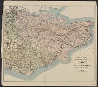
Bartholomew's General map of England and Wales Northern Section., Bartholomew's General map of England and Wales Southern Section., and General map of England & Wales.
Description:
Counties. and Relief shown by spot heights.
Publisher:
Geographic Institute/John Bartholomew & Son,
Subject (Geographic):
England--Administrative and political divisions--Maps, England--Maps, Wales--Administrative and political divisions--Maps, and Wales--Maps
Edinburgh Geographical Institute John Bartholomew & Co
Published / Created:
[1914]
Call Number:
11hc 1914
Container / Volume:
BRBL_00010A
Image Count:
2
Resource Type:
Maps, Atlases & Globes
Description:
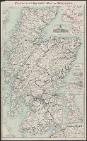
Includes 7 inset maps., Relief shown by spot heights., and Shows principal fortified towns, railways, main and other lines, shipping routes and distances.
Includes 3 insets Tour to Trossachs--Loch Katrine & Loch Lomond-- and ill. of station hotels at Glasgow, Perth and Edinburgh. and Travel information on verso.
Publisher:
John Bartholomew,
Subject (Geographic):
Scotland--Maps
Subject (Name):
Caledonian Railway Company and Edinburgh Geographical Institute
BEIN Osborn pc297: 4 v. bound in 2. Imperfect: p. 171-4 (gathering Ee) in v. 1 wanting (part of "Explanatory index of obsolete words ..."); page no. for xix and xx (v. 1) illegible due to hole in paper where no. are printed. Autograph of William Tytler on t.p. of v. 1. Illegible initials on front free end paper of v. 3. Ms. notes by Alexander Fraser Tytler and another hand (possibly Patrick Fraser Tytler, son of Alexander). Spine titles on bound volumes: Anderson's collection vol. I and Anderson's collection vol. II., Each volume is paginated continuously except v. 1, where each section is paginated individually., Imprint varies: v. 3: Edinburgh: Printed by Mr. Thomas Ruddiman, 1727; v. 4 (pts. 1 and 2): London: Printed by James Bettenham, 1728., Includes bibliographical references., Vol. 1 includes "The editor's general preface" (p. [i]-lv) for all 4 v., Vol. 4 is in 2 pts., Vols. 1-2 and 4 contain a "Contents" section for that v. which is "a list of the books reprinted in it, mentioning from what printed copy they are taken" (v. 1, p. lvii). No contents section is in v. 3 as it contains only one work., Vols. 2-4 have abbreviated title., and With side-notes.
Publisher:
Printed by John Mosman and William Brown, the assigns of James Watson deceased, his Majesty's printers,
Subject (Name):
Anderson, James, 1662-1728, Mary,--Queen of Scots,--1542-1587, Tytler, Patrick Fraser,--1791-1849--Ms. notes, Tytler, William,--1711-1792--Autograph, and Woodhouselee, Alexander Fraser Tytler,--Lord,--1747-1813--Ms. notes
Bartholomew's new map of South America, World survey Bartholomew's map series, and World survey Bartholomew's map series.
Description:
In lower left margin: The Edinburgh Geographical Institute., Includes 8 inset maps and shows railways, steamer routes, and "rivers navigable for trading boats.", Inscription on verso: Hiram Bingham. Mounted on linen., and Relief shown by hachures.
Publisher:
John Bartholomew & Co.,
Subject (Geographic):
South America--Maps
Subject (Name):
Bartholomew, J. G. (John George), 1860-1920, Bingham, Hiram,--1875-1956--Autograph, and Samson, John, 1848-1905